Brzozowa, Staszów County
| Brzozowa | |
|---|---|
| Village | |
 Brzozowa | |
| Coordinates: 50°26′51″N 21°19′01″E / 50.44750°N 21.31694°E | |
| Country |
|
| Voivodeship | Świętokrzyskie |
| County | Staszów |
| Gmina | Połaniec |
| Sołectwo | Brzozowa |
| Elevation | 164.2 m (538.7 ft) |
| Population (31 December 2009 at Census)[1] | |
| • Total |
|
| Time zone | CET (UTC+1) |
| • Summer (DST) | CEST (UTC+2) |
| Postal code | 28-230 |
| Area code(s) | +48 15 |
| Car plates | TSZ |
Brzozowa[2][3][4] [bʐɔˈzɔva] is a village in the administrative district of Gmina Połaniec, within Staszów County, Świętokrzyskie Voivodeship, in south-central Poland. It lies approximately 3 kilometres (2 mi) north-east of Połaniec, 17 km (11 mi) south-east of Staszów, and 69 km (43 mi) south-east of the regional capital Kielce.[5]
The village has a population of ![]() 112.
112.
Demography
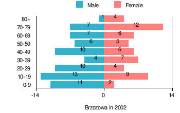
According to the 2002 Poland census, there were 124 people residing in Brzozowa village, of whom 55.6% were male and 44.4% were female. In the village, the population was spread out with 25.8% under the age of 18, 29.8% from 18 to 44, 17.7% from 45 to 64, and 26.6% who were 65 years of age or older.[1]
Table 1. Population level of village in 2002 — by age group[1] SPECIFICATION Measure
unitPOPULATION
(by age group in 2002)TOTAL 0-9 10-19 20-29 30-39 40-49 50-59 60-69 70-79 80 + I. TOTAL person 124 13 22 14 11 16 11 13 19 5 — of which in % 100 10.5 17.7 11.3 8.9 12.9 8.9 10.5 15.3 4 1. BY SEX A. Males person 69 11 13 10 4 10 6 7 7 1 — of which in % 55.6 8.9 10.5 8.1 3.2 8.1 4.8 5.6 5.6 0.8 B. Females person 55 2 9 4 7 6 5 6 12 4 — of which in % 44.4 1.6 7.3 3.2 5.6 4.8 4 4.8 9.7 3.2
Figure 1. Population pyramid of village in 2002 — by age group and sex[1]
Table 2. Population level of village in 2002 — by sex[1] SPECIFICATION Measure
unitPOPULATION
(by sex in 2002)TOTAL Males Females I. TOTAL person 124 69 55 — of which in % 100 55.6 44.4 1. BY AGE GROUP A. At pre-working age person 32 23 9 — of which in % 25.8 18.5 7.3 B. At working age. grand total person 59 35 24 — of which in % 47.6 28.2 19.4 a. at mobile working age person 37 20 17 — of which in % 29.8 16.1 13.7 b. at non-mobile working age person 22 15 7 — of which in % 17.7 12.1 5.6 C. At post-working age person 33 11 22 — of which in % 26.6 8.9 17.7
Former parts of village — physiographic objects
In the years 1970 of last age, sorted and prepared out list part of names of localities for Brzozowa, what you can see in table 3.
Table 3. Index of official names of localities and physiographic objects[6] Names of village — town Names of part of village
— townNames of physiographic objects
— nature of objectsI. Gromada POŁANIEC
- Brzozowa
- Duża Brzozowa
- Mała Brzozowa
- Ściegna
- Borki — pasture, field
- Duże Lipie — pasture, field
- Górka — field
- Kozuba — field
- Łazy — field
- Łóżko — field
- Pasterniki — meadow
- Pod Niwą — field
- Pod Strugą — meadow
- Poręby — field
- Struga — channel
- Ściegna — meadow
- Za Gościńcem — field
- Za Niwą — pasture
References
- 1 2 3 4 5 "Bank Danych Lokalnych – Układ wg klasyfikacji NTS" [Local Data Bank – Layout by NTS nomenclature]. demografia.stat.gov.pl. GUS. 10 March 2011.
- ↑ Bielec, Jan (ed.); Szwałek, Stanisława (1980). Wykaz urzędowych nazw miejscowości w Polsce. T. I: A – J [List of official names of localities in Poland, Vol. I: A – J] (in Polish). Ministry of Administration, Spatial Economy and Environmental Protection (1st ed.). Warsaw, Poland: Central Statistical Office.
- ↑ Sitek, Janusz (1991). Nazwy geograficzne Rzeczypospolitej Polskiej [Geographical names of the Republic of Poland] (in Polish). Ministry of Physical Planning and Construction, Surveyor General of Poland, Council of Ministers' Office, Commission for Establishing Names of Localities and Physiographical Objects (1st ed.). Warsaw, Poland: Eugeniusz Romer State Cartographical Publishing House. ISBN 83-7000-071-1.
- ↑ "Brzozowa, wieś, gmina Połaniec — obszar wiejski (cz. 2), powiat staszowski, województwo świętokrzyskie" [Brzozowa, village, Połaniec Commune — rural area (part of 2), Staszów County, Świętokrzyskie Province, Poland]. Topographical map prepared in 1:10,000 scale. Aerial and satellite orthophotomap (in Polish). Head Office of Geodesy and Cartography, Poland, Warsaw. 2011. geoportal.gov.pl. Retrieved 27 April 2011.
- ↑ "Central Statistical Office (GUS) - TERYT (National Register of Territorial Land Apportionment Journal)" (in Polish). 2008-06-01.
- ↑ Cf. Kaczmarek, Leon (ed.); Taszycki, Witold (1970). Urzędowe nazwy miejscowości i obiektów fizjograficznych. 33. Powiat staszowski województwo kieleckie [Official Names of Localities and Physiographic Objects. 33. Staszów County Kielce Voivodeship] (in Polish). Commission for Establishing Names of Localities and Physiographic Objects (to business use). Vol. 33. Warsaw, Poland: Council of Ministers' Office. Cabinet Office for bureaux of the Supervisory Boards. pp. 33, 77, 79–80, 82, 84, 86, 88–89, 91–92, 94.
| Town and seat |  | ||||||
|---|---|---|---|---|---|---|---|
| Parts of town |
| ||||||
| Villages |
| ||||||
| Part of village |
| ||||||
| Colonies |
| ||||||
| Farmstead |
| ||||||
| Smaller locality | |||||||
Coordinates: 50°26′46″N 21°18′39″E / 50.44611°N 21.31083°E