Bush, Kentucky
| Bush, Kentucky | |
|---|---|
| Unincorporated community | |
 Bush, Kentucky | |
| Coordinates: 37°05′33″N 83°52′13″W / 37.09250°N 83.87028°WCoordinates: 37°05′33″N 83°52′13″W / 37.09250°N 83.87028°W | |
| Country | United States |
| State | Kentucky |
| County | Laurel |
| Elevation | 1,220 ft (370 m) |
| Time zone | Eastern (EST) (UTC-5) |
| • Summer (DST) | EDT (UTC-4) |
| ZIP code | 40724 |
| Area code(s) | 606 |
| GNIS feature ID | 511092[1] |
Bush is an unincorporated community in Laurel County, Kentucky, United States. Bush is located on Kentucky Route 80 in eastern Laurel County, 12 miles (19 km) east-southeast of London.[2] Bush had a post office, which opened on February 18, 1840, and closed on January 22, 2011; it still has its own ZIP code, 40724.[3][4]
References
- ↑ "Bush". Geographic Names Information System. United States Geological Survey.
- ↑ State Primary Road System: Laurel County (PDF) (Map). Kentucky Transportation Cabinet. 2012. Retrieved June 11, 2012.
- ↑ "Postmaster Finder - Post Offices by ZIP Code". United States Postal Service. Retrieved June 11, 2012.
- ↑ United States Postal Service (2012). "USPS - Look Up a ZIP Code". Retrieved 2012-02-15.
Municipalities and communities of Laurel County, Kentucky, United States | ||
|---|---|---|
| City | 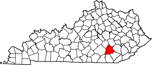 | |
| CDPs | ||
| Unincorporated communities | ||
| Footnotes | ‡This populated place also has portions in an adjacent county | |
This article is issued from Wikipedia - version of the 9/18/2014. The text is available under the Creative Commons Attribution/Share Alike but additional terms may apply for the media files.