Cañon Pintado
|
Cañon Pintado | |
|
Kokopelli, a flute-playing figure common in the Ancestral Puebloan art of the Southwest, at Cañon Pintado about 850-1100 AD | |
| Nearest city | Rangely |
|---|---|
| NRHP Reference # | 75000538 |
| Added to NRHP | 1975[1] |
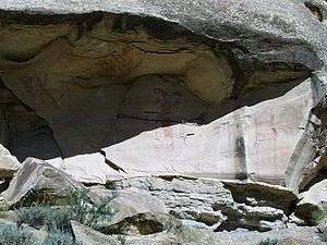
Cañon Pintado, meaning painted canyon, is an archaeological site of Native American rock art located in the East Four Mile Draw, 10.5 miles (16.9 km) south of Rangely in Rio Blanco County, Colorado. Led by Ute guides, the Dominguez-Escalante Expedition, Spanish missionaries in search of a route to California in 1776, passed through this region as they moved north and then west into Utah. The first Europeans to the area, they named it Cañon Pintado, meaning "painted canyon".[2][3]
Rock art
The rock art was probably made by people of the Fremont culture (about AD 650 - 1150) and the Ute (about AD 1200 - 1881). No one has been able to positively identify the significance of the paintings, however, they were probably made to mark significant events or for religious purposes. The Fremont people were described in a Rangely Museum brochure:
The Fremont people built villages, farmed the valley areas and on high points located watchtowers. In hidden places on the cliffs are still found cisterns and granaries where they stored corn and seeds. Petroglyphs of corn stalks are at a number of these sites. Later the Utes hunted the area and used the valley until they were moved to a reservation in 1881.[3]
Sun Dagger Site
There is evidence that some of the petroglyphs may be of astronomical significance. The markings may indicate the significance winter or summer solstice but more data is required to verify these results.[4]
Historic places
Nearby are the following National Register of Historic Places listings in Rio Blanco County, Colorado, all three are prehistoric Fremont culture sites:[5] Prehistoric sites
- Collage Shelter Site - dated from 500 - 1499 AD.
- Carrot Men Pictograph Site - dated from 500 - 1499 AD.
- Fremont Lookout Fortification Site - dated from 0 - 1499 AD.
See also
References
- ↑ National Park Service (2010-07-09). "National Register Information System". National Register of Historic Places. National Park Service.
- ↑ Wilson, D. Ray (1990) Colorado Historical Tour Guide. Carpentersville, IL: Crossroads Communications. pp. 285-287. ISBN 0-916445-26-7.
- 1 2 Boddie, Caryn; Boddie, Peter. (1999) Hiking Colorado II. Helena, MT: Falcon Publishing for the American Hiking Society. pp. 181-182. ISBN 1-56044-714-1.
- ↑ BLM Colorado - Sun Dagger Site Bureau of Land Management, Canon Pintado. 06-30-2010. Retrieved 2011-10-31.
- ↑ National Register of Historic Places in Rio Blanco County American Dreams, Inc. Retrieved 2011-10-6.
| Overview | |||||||||||||||
|---|---|---|---|---|---|---|---|---|---|---|---|---|---|---|---|
| Contemporary peoples native to Colorado |
| ||||||||||||||
| Prehistoric cultures in Colorado |
| ||||||||||||||
| Related articles | |||||||||||||||
| Topics | |
|---|---|
| Lists by states |
|
| Lists by insular areas | |
| Lists by associated states | |
| Other areas | |
| |