Calanque
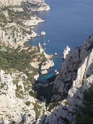
A calanque (from the Corsican and Occitan words of pre-Indo-European origin calanca (plural calanche in Corsican, calancas in Occitan) with meaning "inlet") is a narrow, steep-walled inlet that is developed in limestone, dolomite, or other carbonate strata and found along the Mediterranean coast. A calanque is a steep-sided valley formed within karstic regions either by fluvial erosion or the collapse of the roof of a cave that has been subsequently partially submerged by a rise in sea level.[1][2][3]
Characteristics
Location
The best known examples of this formation can be found in the Massif des Calanques (Massís dei calancas in Occitan, the historic local language) in the Bouches-du-Rhône département of France. This range extends for 20 km in length and 4 km in width along the coast between Marseille and Cassis, culminating in Marseilleveyre (432 m) and Mont Puget (565 m). Similar calanques can also be found on the French riviera near Estérel and on the island of Corsica (see Calanques de Piana). The highest point along the calanques are located at Mount Puget (565 meters)and in the mountains of Marseilleveyre (432 meters).[4] Similarities are seen between calanques, and rias, the river mouths formed along the coast of Brittany in Northern France.

The limestone calanques of the Massif des Calanques lie within the recently created Parc National des Calanques (2012) and include the Calanque de Sormiou, the Calanque de Morgiou, the Calanque d'En-Vau, the Calanque de Port-Pin and the Calanque de Sugiton. There are additional calanques in the parc, further east along the coast, incised into Cap Canaille. These calanques formed in very different rock strata, often in layers of cemented pebble conglomerate.
Calanques are also present in the Italian Apennines, in locations such as the Accona Desert and in the Calanchi natural preserve of Atri.
Geology
Modern day calanques along the Mediterranean Sea are steep-sided valleys that the Holocene (Flandrian) marine transgression partially submerged to form cliff-edged inlets. These valleys were either incised by rivers or created by cave collapse as karstic dry valleys when sea level was lower than present.[1][2][3]
Along the coast of the Mediterranean Sea, some of the valleys, which were flooded to form calanques, might date back to the Messinian salinity crisis between 5.96 and 5.32 million years ago. During this period of time, the Mediterranean Sea became isolated from the Atlantic Ocean and its sea level dropped at least 1,500 meters below the level of the Atlantic Ocean.[5][6] As a result, not only did evaporites accumulate on the abyssal plains of the Mediterranean Sea, but also rivers flowing into it deepened their valleys by 100s of meters. For example, the Rhône River cut a canyon as deep as 576 meters into Cretaceous carbonate strata near its confluence with its tributary the Ardèche. Fluvial erosion by smaller streams and rivers created numerous other deep, steep-sided valleys in response to the greatly lowered sea level at this time.[7] Also at this time, steep-walled, dry karstic valleys were formed by the collapse of caves that developed in limestone, dolomite, and other carbonate rocks in response to the greatly lowered sea level of the Mediterranean Sea.[8] Later, during the Pleistocene, these valleys were further enlarged and modified by fluvial, karst, and other processes during interglacial drops of sea level within the 100 meter range. During these periods of interglacial low sea level, additional steep-sided valleys, which were later flooded to create calanques, along the Mediterranean coastline were formed by fluvial and karst processes.[9] Today, they can be seen as deep, narrow valleys that are partly submerged by the sea and are made up of limestone or granite.[4]


Ecosystem
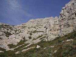
The calanques have a particular ecosystem, as soil is almost non-existent there, and the limestone cliffs instead contain numerous cracks into which the roots of plants are anchored. Nevertheless, the biota is diverse, with over 900 plant species,[10] including a number of endemics like the Marseille Tragacanth and Sabline de Marseille: members of the Papilionaceae family, which can only be found in the hills of Marseille.[11]
In places where cliffs are less vertical, the vegetation is a classical Mediterranean maquis, typically consisting of densely growing evergreen shrubs such as sage, juniper and myrtle. It is similar to heath in many aspects, but with taller shrubs, typically 2–4 m high as opposed to 0.2–1 m for heath.
Like anywhere on Mediterranean coast, Calanques' climate is arid, with moisture during much of the year coming only from evaporation of the sea. This xericity associated with the salt spray conditions the subsistence of an adapted vegetation.
The calanques also shelter rabbits, foxes, large crows and Bonelli's eagles, as well as many reptiles and wild boars.
Tourism
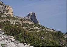
The calanques between Marseille and Cassis are popular amongst tourists and locals alike, offering several vantage points (such as the Corniche des Crêtes and Cap Canaille) allowing spectacular panoramas. A great number of hikers frequent the area, following numerous pre-marked trails. The cliffs are also used as training spots for rock climbers. However, this excessive use has posed problems of potential damage to this delicate microhabitat.
Most of the calanques are also closed to the public during the summer (typically July through September) due to the risks of forest fire that often happen during the dry season.
The best time to visit calanques is probably March through May, when temperatures are cool and, unlike autumn and winter, rain is rare. As no fresh water sources are available in the calanques, visitors are advised to carry large supplies of water, especially during the summer heat, to prevent dehydration.
Boat tours are also available starting either from Marseille, Cassis or La Ciotat, which can provide for some spectacular sightseeing.
In April 2012, most of the calanques were declared National Parks due to their uniqueness.[12]
The Cosquer Cave
The Cosquer cave is an underwater grotto in the Calanque de Morgiou, 37 m underwater, that was once inhabited during Paleolithic, when the sea level was much lower than today. Its walls are covered with paintings and engravings dating back to between 27,000 and 19,000 BC and depict many terrestrial animals such as bison, ibex, and horses as well as sea mammals like seals and auks.[9][13]
See also
References
- 1 2 Bird, E.C.F., 2008, Coastal Geomorphology: An Introduction, 2nd ed. John Wiley and Sons Ltd. West Sussex, England. ISBN 978-0-470-51729-1
- 1 2 Goudie, A., 2004, Encyclopedia of Geomorphology. Routledge. London, England. ISBN 0-415-27298-X
- 1 2 Monroe, W.H., 1970, A Glossary of Karst Terminology. Water-Supply Paper 1899-K. U.S. Geological Survey. Reston, Virginia.
- 1 2 "THE CALANQUES, Provence". 2012. Retrieved 2012-10-10.
- ↑ Krijgsman W., F.J. Hilgen, I. Raffi, F.J. Sierro, and D.S. Wilson, 1999, Chronology, causes and progression of the Messinian salinity crisis. Nature. v. 400, no. 6745, pp. 652-655.
- ↑ Ryan W.B.F., 1976, Quantitative evalutation of the depth of the Western Mediterranean before during and after the Last Miocene salinity crisis. Sedimentology. v. 23, no. 6, pp. 791-813.
- ↑ Mocochain, L., P. Audra, G. Clauzon, O. Bellier, J.-Y. Bigot, O. Parize, and P. Monteil, 2009, The effect of river dynamics induced by the Messinian Salinity Crisis on karst landscape and caves: Example of the Lower Ardèche river (mid Rhône valley) Geomorphology, v. 106, no. 1-2, pp. 46-61.
- ↑ Audra, P., L. Mocochain, H. Camus, E. Gilli, G. Clauzon, and J.-Y. Bigot, 2004, The effect of the Messinian Deep Stage on karst development around the Mediterranean Sea. Examples from Southern France. Geodinamica Acta. v. 17, no. 6, pp. 27–38.
- 1 2 Collina-Girard, J., 1996. Prehistory and coastal karst area: Cosquer Cave and the “Calanques” of Marseille. Karstologia. v. 27, pp. 27-40.
- ↑ http://www.visite-bateau-calanques-marseille-cassis.fr/data/php/getfile.php?nom=La-faune-et-la-flore-des-Calanques.pdf
- ↑ http://www.rivieratimes.com/index.php/provence-cote-dazur-article/items/wild-and-natural-beauty-in-frances-national-parks.html
- ↑ "The Calanques Near Cassis". 2012. Retrieved 2012-10-10.
- ↑ Collina-Girard, J., 2004, La transgression finiglaciaire, l’archéologie et les textes (exemples de la grotte Cosquer et du mythe de l’Atlantide) Human records of recent geological evolution in the Mediterranean Basin-historical and archaeological evidence. CIESM Workshop Monographs. no. 24, page 63-70.
External links
| Wikimedia Commons has media related to Calanques. |
- The Calanques web site : Calanques de cassis
- Calanques photo at maps.google.com
Coordinates: 43°12′37″N 5°25′18″E / 43.21028°N 5.42167°E