Calderone glacier
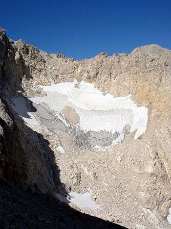
The Calderone glacier (Ghiacciaio del Calderone) is located in the Gran Sasso d’Italia mountain group in the Italian province of Teramo. It lies just beneath the Corno Grande, the highest peak in the Apennines.
With the disappearance of the Corral de la Veleta glacier (37° N) in 1913, which lay in Spain's Sierra Nevada, "Il Calderone" became Europe's southernmost known glacier (42°28′N, 13°33′E). If present deglaciation trends continue, the Calderone may soon share Corral de la Veleta's fate. The discovery of a number of small glaciers in the Prokletije in 2009 seemed to threaten Calderone's record, however the Italian glacier is slightly further south.[1]
Historical surface of the glacier
In 1794, the Calderone had an estimated volume of over 4 million cubic metres; by 1916, the glacier’s volume had decreased to 3.3 million cubic metres, and by 1990, it had decreased to 360,931 cubic metres. In 1998 Italian glaciologists at a symposium in L'Aquila predicted that the Calderone would vanish within a few decades.
Some glaciologists have predicted that the glacier will disappear by 2020. However, 2014 has been slightly positive for the glacier. By the end of August 2014, the volume of residual ice was larger than during the same period in 2013.
| Surface and volume of the glacier | ||
| Year | Surface m² | Volume m³ |
|---|---|---|
| 1794 | 104.257 | 4.332.207 |
| 1884 | 90.886 | 3.382.166 |
| 1916 | 63.335 | 3.386.485 |
| 1934 | 59.713 | 2.461.529 |
| 1960 | 60.030 | 1.729.934 |
| 1990 | 52.586 | 360.931 |
| 2005 | 32.900 | --- |
| 2006 | 32.700 | --- |
| 2008 | 35.545 | --- |
References
- Visconti, Guido; M. Beniston; Emilio D. Iannorelli; Diego Barba. Global Change and Protected Areas (Advances in Global Change Research). New York: Kluwer Academic Publishers. pp. 425–435. ISBN 0-7923-6918-1.
Coordinates: 42°28′N 13°33′E / 42.467°N 13.550°E