Camberwell, Victoria
| Camberwell Melbourne, Victoria | |||||||||||||
|---|---|---|---|---|---|---|---|---|---|---|---|---|---|
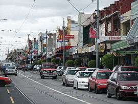 Busy Burke Road, Camberwell (looking north from Camberwell Junction) | |||||||||||||
 Camberwell | |||||||||||||
| Coordinates | 37°50′06″S 145°04′16″E / 37.835°S 145.071°ECoordinates: 37°50′06″S 145°04′16″E / 37.835°S 145.071°E | ||||||||||||
| Population | 20,029 (2011)[1] | ||||||||||||
| • Density | 3,453/km2 (8,940/sq mi) | ||||||||||||
| Postcode(s) | 3124 | ||||||||||||
| Area | 5.8 km2 (2.2 sq mi) | ||||||||||||
| Location | 10 km (6 mi) from Melbourne | ||||||||||||
| LGA(s) | City of Boroondara | ||||||||||||
| State electorate(s) | |||||||||||||
| Federal Division(s) | Kooyong | ||||||||||||
| |||||||||||||
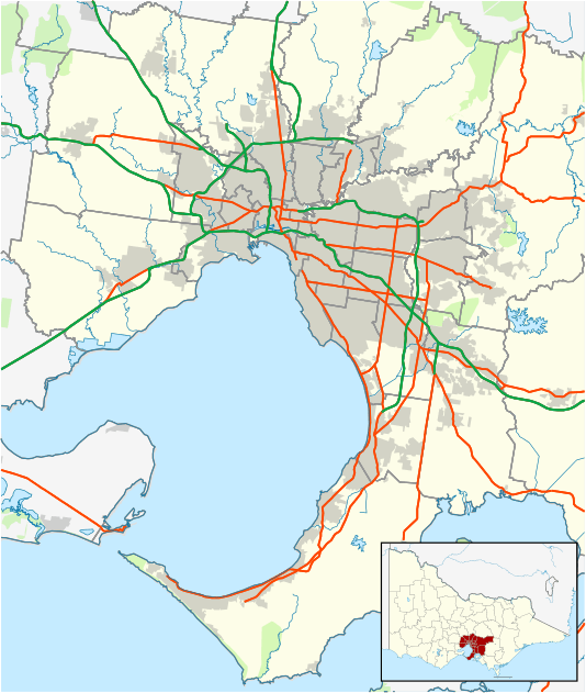
Camberwell is a suburb of Melbourne, Victoria, Australia, 10 km east of Melbourne's Central Business District. Its local government area is the City of Boroondara. At the 2011 Census, Camberwell had a population of 20,029.
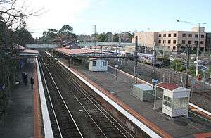
The western, southern and eastern boundaries of the suburb generally follow Burke Road, Toorak Road and Warrigal Road respectively. The northern boundary generally follows Riversdale Road, except for an area in the northwest where it extends upwards to Canterbury Road, incorporating Camberwell, East Camberwell and Riversdale railway stations.
Camberwell is designated one of 26 Principal Activity Centres in the Melbourne 2030 Metropolitan Strategy.
A feature of Camberwell is the Burke Road shopping strip, which stretches north, approximately 600 m from Camberwell Junction, where three tram routes converge - the 70, 72, and 75. Halfway up the shopping strip is Camberwell railway station, which services the Belgrave, Lilydale, and Alamein train lines. East Camberwell, Riversdale, Willison, and Hartwell stations also lie within the suburb's boundaries. Several bus routes also cover the area.
The historic Rivoli Cinemas sit just west of Camberwell Junction, in the adjacent suburb of Hawthorn East.
Camberwell has several parks, reserves and playgrounds, most notably, Frog Hollow Reserve, Fordham Gardens, Cooper Reserve, Bowen Gardens, Lynden Park, Highfield Park, Riversdale Park and Willison Park. [2]
Camberwell is home to a number of notable head offices, including Pacific Brands and Bakers Delight.
History
Camberwell received its name as a result of an early settler being reminded of the way three roads intersected in the south London district of Camberwell. This intersection is now known as Camberwell Junction. The development that followed was a product of the expansion of Melbourne's suburban rail network in the 1880s.
Camberwell Post Office opened on 12 October 1864.[3]
The Prospect Hill area is adjacent to the railway station and is the oldest part of the suburb. The original subdivision was relatively generous blocks, which were quickly filled with fine Victorian and Edwardian houses. Due to its hilly topography, many east-west streets in the Prospect Hill area have an excellent view of Melbourne's Central Business District. Its main commercial centre developed along Burke Road from its railway station to Camberwell Junction, 500m to the south. Several tram routes converge on this point.
Though the area was originally agricultural, Camberwell is now one of the most well-established of Melbourne's affluent suburbs. It is part of the City of Boroondara, the local government area with the lowest socio-economic disadvantage index in Australia. There is almost no industrial land in Camberwell, and commercial uses are concentrated near the Burke Road precinct, which has long been one of the busiest in suburban Melbourne. House prices in Boroondara are well above the metropolitan median and those in the Prospect Hill precinct are several times the Boroondara median.
Development controversies
In the 1980s a planned major development to the east of the Burke Road shopping strip met substantial opposition from local residents. National Mutual Life Association proposed a 24,000 sq.m. three-storey enclosed shopping centre,[4] which drew substantial objection.[5][6] Developer Floyd Podgornik's Podgor Group (Podgor) purchased the site from National Mutual in 1987[7] and submitted revised plans to Camberwell Council. When the Council approved Podgor's plans in 1988, 400 residents stormed the meeting.[8] At elections later that year, anti-development protesters won control of the Council[9] and although the developer subsequently proposed a lesser development,[10] in 1990 it rescinded its decision to approve the shopping centre. Subsequently Podgor sued the Council to court and was awarded $25m in damages.[11]
Similar opposition was mounted regarding plans dating from 1999 to develop Camberwell railway station to incorporate retail and office development.[11] High profile present and past residents Geoffrey Rush and Barry Humphries supported the protest action,[11] but the development was finally approved in 2009.[12]
Neighbourhoods
East Camberwell, Hartwell, Riversdale and Willison are four officially named[13] neighbourhoods, within the general area of the railway stations of the same name.
Notable residents
- Adam Plack - Didgeridoo player[14]
- Geoffrey Rush - Australian actor[15]
- Sir Rupert Hamer - Victorian Premier 1971 - 1981
- Barry Humphries - Australian comedian, best known for his alter ego Dame Edna Everage; Humphries grew up in 36 Christowel Street, in the Golf Links Estate[16]
- Peter Costello - Former Federal Treasurer and former MP for Higgins[17]
- Norman Lacy - Victorian Arts and Educational Services Minister 1979 - 1982
- Kylie Minogue and Dannii Minogue - Australian singers, were raised in nearby Surrey Hills and attended Camberwell High School.[18][19][20]
- Dom Tyson - AFL footballer for the Melbourne Football Club
Transport
Camberwell is well-serviced by public transport, with three rail lines, three tram routes and three bus services operating throughout the suburb.
Bus
- 285: Doncaster Park & Ride - Camberwell via North Balwyn[21]
- 612: Box Hill Central Shopping Centre – Chadstone Shopping Centre[22]
- 968: NightRider - City - Knox - Bayswater - Belgrave via Toorak Road, Burwood Highway[23]
Tram
- 70: Waterfront City Docklands - Wattle Park[24]
- 72: Melbourne University – Camberwell[25]
- 75: Etihad Stadium – Vermont South
Train
Schools
Culture
The Camberwell Sunday Market has been operated by the Rotary Club of Balwyn since 1976 and comprises 370 stallholders, selling secondhand clothing, books, furniture, and crafts.[26] Camberwell Football Club participated in the Victorian Football Association from 1926 to 1991.[27]
Since October 1996 the Camberwell Magpies Cricket Club has played in the Victorian Premier Cricket competition.
Ten churches were established in the area; Camberwell South Anglican Church,[28] St Dunstan's Anglican,St John's Anglican, St Mark's Anglican, Our Lady of Victories Basilica, Salvation Army, Methodist (now Uniting), Presbyterian, Greek Orthodox, Church of Christ and Baptist. Camberwell Baptist Church was constituted in 1891 and has met on the same site in Riversdale Road, Hawthorn East, near Camberwell Junction, since its inception.[29]
See also
- City of Camberwell - the former local government area.
References
- ↑ Australian Bureau of Statistics (31 October 2012). "Camberwell (State Suburb)". 2011 Census QuickStats. Retrieved 2012-07-19.
- ↑ "Parks&Reserves". Whereis.
- ↑ Premier Postal History. "Post Office List". Retrieved 2008-04-11.
- ↑ "Planning amendment may soon be tested". The Age. 27 November 1985. Retrieved 15 December 2009.
- ↑ "Burke Road project deadline set". The Age. 29 October 1986. Retrieved 15 December 2009.
- ↑ "Camberwell fighting push for new shopping centre". The Age. 18 May 1987. Retrieved 15 December 2009.
- ↑ "Camberwell residents await Podgor moves". The Age. 7 October 1987. Retrieved 15 December 2009.
- ↑ "Camberwell residents storm council". The Age. 17 May 1988. Retrieved 15 December 2009.
- ↑ "Podgor plan in doubt". The Age. 8 August 1988. Retrieved 15 December 2009.
- ↑ "New junction plans go to Camberwell council". The Age. 17 May 1989. Retrieved 15 December 2009.
- 1 2 3 "Battle Stations". Melbourne: The Age. 28 April 2004. Retrieved 15 December 2009.
- ↑ Lahey, Kate (9 July 2009). "State policy wins: Camberwell project approved". Melbourne: The Age. Retrieved 15 December 2009.
- ↑ "Community and neighbourhood centres | City of Boroondara". www.boroondara.vic.gov.au. Retrieved 2015-06-01.
- ↑ "Adam Plack". Maestro. Retrieved 2009-08-11.
- ↑ "Rush hour". The Age, Melbourne. 2007-03-08. Retrieved 2009-08-11.
- ↑ "The evolution of Edna". The Age, Melbourne. 2006-01-21. Retrieved 2009-08-11.
- ↑ "Anti-war vigil outside treasurer's Melbourne home". AAP General News. 2003-03-16. Retrieved 2009-08-11.
- ↑ "Born today...Kylie Minogue". Brisbane Times. 2008-05-28. Retrieved 2009-08-11.
- ↑ "Kylietown". The Age, Melbourne. 2006-10-08. Retrieved 2009-08-11.
- ↑ "Fashion victim". Sydney Morning Herald. 2003-04-30. Retrieved 2009-08-11.
- ↑ "285 - Doncaster Park & Ride - Camberwell via North Balwyn". Public Transport Victoria. Retrieved 3 March 2016.
- ↑ Route 612 Box Hill - Chadstone timetable Public Transport Victoria
- ↑ "968 - NightRider - City - Knox - Bayswater - Belgrave via Toorak Road, Burwood Highway". Public Transport Victoria. Retrieved 5 May 2014.
- ↑ "70 - Waterfront City Docklands - Wattle Park". Public Transport Victoria. Retrieved 5 May 2014.
- ↑ Route 72 Melbourne University – Camberwell timetable Public Transport Victoria
- ↑ "Camberwell Sunday Market". Rotary Club of Balwyn. Retrieved 16 December 2009.
- ↑ "Camberwell". fullpointsfooty.net. Retrieved 16 December 2009.
- ↑ http://www.csac.org.au/im-new/
- ↑ A.H. Praeger (ed.) (1991). 100 Years of Christian Ministry in the Camberwell/Hawthorn Area.
External links
![]() Media related to Camberwell, Victoria at Wikimedia Commons
Media related to Camberwell, Victoria at Wikimedia Commons
- Australian Places - Camberwell
- Boroondara Residents' Action Group - BRAG
- The Camberwell Traders' Association website