Canada, Kansas
| Canada, Kansas | |
|---|---|
| Unincorporated community | |
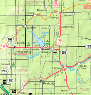 KDOT map of Marion County (legend) | |
 Canada  Canada | |
| Coordinates: 38°21′15″N 97°6′46″W / 38.35417°N 97.11278°WCoordinates: 38°21′15″N 97°6′46″W / 38.35417°N 97.11278°W[1] | |
| Country | United States |
| State | Kansas |
| County | Marion |
| Township | Gale |
| Platted | 1883 |
| Elevation[1] | 1,362 ft (415 m) |
| Time zone | CST (UTC-6) |
| • Summer (DST) | CDT (UTC-5) |
| Area code | 620 |
| FIPS code | 20-10350 [1] |
| GNIS feature ID | 0477365 [1] |
|
| |
Canada is an unincorporated community in Marion County, Kansas, United States.[1] It is named for many Canadian immigrants coming to the area.[2]
History
Early history
For many millennia, the Great Plains of North America was inhabited by nomadic Native Americans. From the 16th century to 18th century, the Kingdom of France claimed ownership of large parts of North America. In 1762, after the French and Indian War, France secretly ceded New France to Spain, per the Treaty of Fontainebleau.
19th century
In 1802, Spain returned most of the land to France. In 1803, most of the land for modern day Kansas was acquired by the United States from France as part of the 828,000 square mile Louisiana Purchase for 2.83 cents per acre.
In 1854, the Kansas Territory was organized, then in 1861 Kansas became the 34th U.S. state. In 1855, Marion County was established within the Kansas Territory, which included the land for modern day Canada.[3]
David Christie, former Speaker of the Canadian Senate, sent his sons to buy 3 square miles (8 km2) near the future site of Canada. Many Canadian immigrants moved to the area, thus was the source of the community. Canada was platted on December 15, 1883, but never incorporated. Canada had a Post Office from 1884 to 1954.[2]
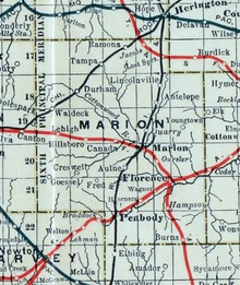
As early as 1875, city leaders of Marion held a meeting to consider a branch railroad from Florence. In 1878, Atchison, Topeka and Santa Fe Railway and parties from Marion County and McPherson County chartered the Marion and McPherson Railway Company.[4] In 1879, a branch line was built from Florence to McPherson, in 1880 it was extended to Lyons, in 1881 it was extended to Ellinwood.[5] The line was leased and operated by the Atchison, Topeka and Santa Fe Railway. The line from Florence to Marion, was abandoned in 1968.[6] In 1992, the line from Marion to McPherson was sold to Central Kansas Railway. In 1993, after heavy flood damage, the line from Marion through Canada to McPherson was abandoned and removed. The original branch line connected Florence, Marion, Canada, Hillsboro, Lehigh, Canton, Galva, McPherson, Conway, Windom, Little River, Mitchell, Lyons, Chase, Ellinwood.
A post office existed in Canada from February 20, 1884 to February 28, 1954.[7]
20th century
From 1964 to 1968, the Marion Reservoir was constructed north of Canada.
21st century
In August 2015, a film crew for an advertising agency in Toronto, Ontario came to Canada to interview residents and give away New Balance shoes for a Canadian TV commercial.[8]
Geography
Canada is located at 38°21′15″N 97°6′46″W / 38.35417°N 97.11278°W (38.3541802, -97.1128030),[1] approximately halfway between Marion and Hillsboro.
Area attractions
- Marion Reservoir, 1 mile (2 km) north of Canada. The Hillsboro cove is closest to Canada. Exits along US-56: French Creek cove (Limestone Road), Hillsboro cove (Nighthawk Road), Overlook and Dam (Old Mill Road), Marion cove and Cottonwood Point cove (Pawnee Road).
Education
Primary and secondary education
Canada is part of Unified School District 408.[9][10] The high school is a member of T.E.E.N., a shared video teaching network between five area high schools.[11] All students attend schools in Marion.
- Marion High School, located in Marion.
- Marion Middle School, located in Marion.
- Marion Elementary School, located in Marion.
Infrastructure
Transportation
U.S. Route 56 highway is 0.5 miles (0.80 km) north of the community. U.S. 56 was previously located 0.5 miles (0.80 km) south of the community.
Utilities
- Internet
- TV
- Satellite is provided by DirecTV, Dish Network.
- Terrestrial is provided by regional digital TV stations.
- Electricity
- Community and Rural areas provided by Flint Hills RECA.
- Water
- Community and Rural areas provided by Marion County RWD #4.
See also
- Gale Township, Marion County, Kansas (location of Canada)
- Historical Maps of Marion County, Kansas
Further reading
- Beginnings in the Canada Community; H.J. Siebert; Marion Record. September 23, 1937.
References
- 1 2 3 4 5 6 Geographic Names Information System (GNIS) details for Canada, Kansas; United States Geological Survey (USGS); October 13, 1978.
- 1 2 Marion County Kansas, Past and Present; Sondra Van Meter; 1972.
- ↑ The History of Marion County and Courthouse
- ↑ Marion County Kansas : Past and Present; Sondra Van Meter; MB Publishing House; LCCN 72-92041; 344 pages; 1972.
- ↑ Fourth Annual Report of the Board of Railroad Commissioners for the Year Ending December 1, 1886 in State of Kansas; Kansas Publishing House; 1886.
- ↑ Railway Abandonment 1968
- ↑ "Kansas Post Offices, 1828-1961 (archived)". Kansas Historical Society. Archived from the original on October 9, 2013. Retrieved 14 June 2014.
- ↑ Canadians discover ‘the other Canada’, page 4; Peabody Gazette-Bulletin; 10 pages; August 19, 2015.
- ↑ USD 408
- ↑ Kansas School District Boundary Map Archived July 21, 2011, at the Wayback Machine.
- ↑ T.E.E.N. video teaching network
External links
| Wikimedia Commons has media related to Canada, Kansas. |
- Video
- Schools
- USD 408, school district for Marion, Florence, Eastshore, Canada, Aulne, nearby rural areas of Marion County
- USD 408 School District Boundary Map, KDOT
- Historical
- Marion County cemetery list, archive of KsGenWeb
- Marion County history bibliography, Marion County school bibliography, Kansas Historical Society
- Maps
- Marion County Maps: Current, Historic, KDOT
- Topo Map of Marion / Aulne / Canada area, USGS
Municipalities and communities of Marion County, Kansas, United States | ||
|---|---|---|
| Cities | 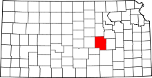 | |
| Unincorporated communities | ||
| Ghost towns | ||
| Townships | ||
| Footnotes | ‡This populated place also has portions in an adjacent county or counties | |