Canal de Bolama
Canal de Bolama
 | |
|---|---|
| Coordinates | 11°29′00″N 15°37′00″W / 11.4833°N 15.6167°WCoordinates: 11°29′00″N 15°37′00″W / 11.4833°N 15.6167°W |
| Ocean/sea sources | Atlantic Ocean |
| Basin countries | Guinea Bissau |
| Max. length | 14 km (8.7 mi) |
| Max. width | 7 km (4.3 mi) |
| Islands | Galinhas Island[1] |
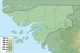
Canal de Bolama[2] is a strait in the coast of Guinea Bissau on the Atlantic Ocean.
Geography
The Canal de Bolama runs from NW to SE and is located to the east of the Bissagos Islands, separating Galinhas Island, at the eastern end of the group, from Bolama, the easternmost island close to the mainland.[1]
References
- 1 2 GoogleEarth
- ↑ "Canal de Bolama". Mapcarta. Retrieved 14 October 2016.
This article is issued from Wikipedia - version of the 10/17/2016. The text is available under the Creative Commons Attribution/Share Alike but additional terms may apply for the media files.