Capergnanica
| Capergnanica | |
|---|---|
| Comune | |
| Comune di Capergnanica | |
 Capergnanica Location of Capergnanica in Italy | |
| Coordinates: 45°20′N 9°39′E / 45.333°N 9.650°ECoordinates: 45°20′N 9°39′E / 45.333°N 9.650°E | |
| Country | Italy |
| Region | Lombardy |
| Province / Metropolitan city | Province of Cremona (CR) |
| Frazioni | Passarera |
| Area | |
| • Total | 6.8 km2 (2.6 sq mi) |
| Elevation | 77 m (253 ft) |
| Population (Dec. 2004) | |
| • Total | 1,801 |
| • Density | 260/km2 (690/sq mi) |
| Demonym(s) | Capergnanichesi |
| Time zone | CET (UTC+1) |
| • Summer (DST) | CEST (UTC+2) |
| Postal code | 26010 |
| Dialing code | 0373 |
Capergnanica is a comune (municipality) in the Province of Cremona in the Italian region Lombardy, located about 45 kilometres (28 mi) southeast of Milan, about 45 kilometres (28 mi) south of Bergamo and about 40 kilometres (25 mi) northwest of Cremona. As of 31 December 2004, it had a population of 1,801 and an area of 6.8 square kilometres (2.6 sq mi).[1]
The municipality of Capergnanica contains the frazione (subdivision) Passarera.
Capergnanica borders the following municipalities: Casaletto Ceredano, Chieve, Credera Rubbiano, Crema, Ripalta Cremasca.
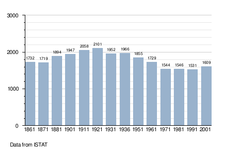
Demographic evolution
References
This article is issued from Wikipedia - version of the 10/6/2016. The text is available under the Creative Commons Attribution/Share Alike but additional terms may apply for the media files.