Malagnino
| Malagnino | |
|---|---|
| Comune | |
| Comune di Malagnino | |
 Malagnino Location of Malagnino in Italy | |
| Coordinates: 45°8′N 10°7′E / 45.133°N 10.117°ECoordinates: 45°8′N 10°7′E / 45.133°N 10.117°E | |
| Country | Italy |
| Region | Lombardy |
| Province / Metropolitan city | Province of Cremona (CR) |
| Area | |
| • Total | 10.8 km2 (4.2 sq mi) |
| Population (Dec. 2004) | |
| • Total | 1,260 |
| • Density | 120/km2 (300/sq mi) |
| Time zone | CET (UTC+1) |
| • Summer (DST) | CEST (UTC+2) |
| Postal code | 26030 |
| Dialing code | 0372 |
Malagnino is a comune (municipality) in the Province of Cremona in the Italian region Lombardy, located about 80 kilometres (50 mi) southeast of Milan and about 7 kilometres (4 mi) east of Cremona. As of 31 December 2004, it had a population of 1,260 and an area of 10.8 square kilometres (4.2 sq mi).[1]
Malagnino borders the following municipalities: Bonemerse, Cremona, Gadesco-Pieve Delmona, Pieve d'Olmi, Sospiro, Vescovato.
In the early 2000s, many new buildings were built, because it is near Cremona and it is an interesting place for young couples seeking a house in the countryside but not too far from the town.
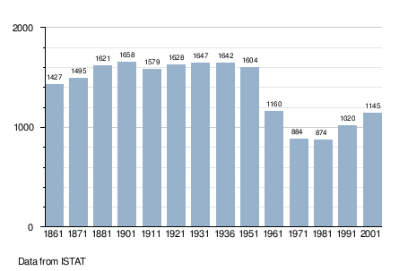
Demographic evolution
References
This article is issued from Wikipedia - version of the 1/31/2015. The text is available under the Creative Commons Attribution/Share Alike but additional terms may apply for the media files.