Capulin, New Mexico
| Capulin, New Mexico | |
|---|---|
| Census-designated place | |
 Capulin, New Mexico | |
| Coordinates: 36°44′28″N 103°59′37″W / 36.74111°N 103.99361°WCoordinates: 36°44′28″N 103°59′37″W / 36.74111°N 103.99361°W | |
| Country | United States |
| State | New Mexico |
| County | Union |
| Area[1] | |
| • Total | 1.480 sq mi (3.83 km2) |
| • Land | 1.480 sq mi (3.83 km2) |
| • Water | 0 sq mi (0 km2) |
| Elevation | 6,844 ft (2,086 m) |
| Population (2010)[2] | |
| • Total | 66 |
| • Density | 45/sq mi (17/km2) |
| Time zone | Mountain (MST) (UTC-7) |
| • Summer (DST) | MDT (UTC-6) |
| ZIP code | 88414 |
| Area code(s) | 575 |
| GNIS feature ID | 902195[3] |
Capulin is a census-designated place and unincorporated community in Union County, New Mexico, United States. Its population was 66 as of the 2010 census. Capulin had a post office until August 13, 2011; it still has its own ZIP code, 88414.[4][5] U.S. Route 64 and U.S. Route 87 pass through the community.
References
- ↑ "US Gazetteer files: 2010, 2000, and 1990". United States Census Bureau. 2011-02-12. Retrieved 2011-04-23.
- ↑ "American FactFinder". United States Census Bureau. Archived from the original on 2013-09-11. Retrieved 2011-05-14.
- ↑ "Capulin". Geographic Names Information System. United States Geological Survey.
- ↑ United States Postal Service (2012). "USPS - Look Up a ZIP Code". Retrieved 2012-02-15.
- ↑ "Postmaster Finder - Post Offices by ZIP Code". United States Postal Service. Retrieved March 4, 2014.
Municipalities and communities of Union County, New Mexico, United States | ||
|---|---|---|
| Town | 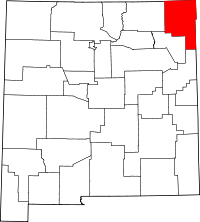 | |
| Villages | ||
| CDP | ||
| Other unincorporated communities | ||
This article is issued from Wikipedia - version of the 11/14/2016. The text is available under the Creative Commons Attribution/Share Alike but additional terms may apply for the media files.