Cattle Creek, Colorado
| Cattle Creek, Colorado | |
|---|---|
| Census-designated place | |
 Cattle Creek  Cattle Creek | |
| Coordinates: 39°28′9″N 107°15′55″W / 39.46917°N 107.26528°WCoordinates: 39°28′9″N 107°15′55″W / 39.46917°N 107.26528°W | |
| Country |
|
| State |
|
| County | Garfield County |
| Area | |
| • Total | 1.30 sq mi (3.36 km2) |
| • Land | 1.30 sq mi (3.36 km2) |
| • Water | 0.0 sq mi (0.0 km2) |
| Elevation | 6,030 ft (1,840 m) |
| Population (2010) | |
| • Total | 641 |
| • Density | 495/sq mi (191.1/km2) |
| Time zone | MST (UTC-7) |
| • Summer (DST) | MDT (UTC-6) |
| Area code(s) | 970 |
| FIPS code | 08-12470 |
| GNIS feature ID | 2583221 |
Cattle Creek is a census-designated place (CDP) in Garfield County, Colorado, United States. The population as of the 2010 census was 641.[1]
It is located in southeastern Garfield County along Colorado State Highway 82 in the valley of the Roaring Fork River. Cattle Creek, a tributary of the Roaring Fork, forms the southern edge of the CDP. Highway 82 leads north 7 miles (11 km) to Glenwood Springs, the county seat, and south 6 miles (10 km) to Carbondale. According to the U.S. Census Bureau, the area of the CDP is 1.30 square miles (3.36 km2), all of it land.[1]
See also
References
- 1 2 "Geographic Identifiers: 2010 Demographic Profile Data (G001): Cattle Creek CDP, Colorado". American Factfinder. U.S. Census Bureau. Retrieved November 16, 2016.
| Wikimedia Commons has media related to Cattle Creek, Colorado. |
Municipalities and communities of Garfield County, Colorado, United States | ||
|---|---|---|
| Cities | 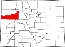 | |
| Towns | ||
| CDPs | ||
| Unincorporated communities | ||
This article is issued from Wikipedia - version of the 11/16/2016. The text is available under the Creative Commons Attribution/Share Alike but additional terms may apply for the media files.