Cave Township, Franklin County, Illinois
| Cave Township | |
|---|---|
| Township | |
 Location in Franklin County | |
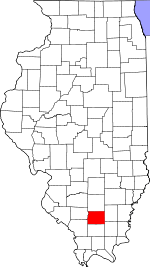 Franklin County's location in Illinois | |
| Coordinates: 37°54′24″N 88°45′27″W / 37.90667°N 88.75750°WCoordinates: 37°54′24″N 88°45′27″W / 37.90667°N 88.75750°W | |
| Country | United States |
| State | Illinois |
| County | Franklin |
| Established | November 4, 1884 |
| Area | |
| • Total | 36.51 sq mi (94.6 km2) |
| • Land | 35.75 sq mi (92.6 km2) |
| • Water | 0.76 sq mi (2.0 km2) 2.08% |
| Elevation | 476 ft (145 m) |
| Population (2010) | |
| • Total | 1,756 |
| • Density | 49.1/sq mi (19.0/km2) |
| Time zone | CST (UTC-6) |
| • Summer (DST) | CDT (UTC-5) |
| ZIP codes | 62890, 62896 |
| GNIS feature ID | 0428777 |
Cave Township is one of twelve townships in Franklin County, Illinois, USA. As of the 2010 census, its population was 1,756 and it contained 834 housing units.[1]
Geography
According to the 2010 census, the township has a total area of 36.51 square miles (94.6 km2), of which 35.75 square miles (92.6 km2) (or 97.92%) is land and 0.76 square miles (2.0 km2) (or 2.08%) is water.[1]
Cities, towns, villages
Unincorporated towns
- Parrish
Extinct towns
- Ferber
- Kegley
- Locust Grove
Cemeteries
The township contains these six cemeteries: Carter's Temple, Clem, Downs, Eubanks, Isaacs, and Smothers.
Major highways
Lakes
- Thompsonville Lake
- West Frankfort City Lake
Political districts
- Illinois' 12th congressional district
- State House District 117
- State Senate District 59
References
- "Cave Township, Franklin County, Illinois". Geographic Names Information System. United States Geological Survey. Retrieved 2010-01-16.
- United States Census Bureau 2007 TIGER/Line Shapefiles
- United States National Atlas
- 1 2 "Population, Housing Units, Area, and Density: 2010 - County -- County Subdivision and Place -- 2010 Census Summary File 1". United States Census. Retrieved 2013-05-28.
External links

Municipalities and communities of Franklin County, Illinois, United States | ||
|---|---|---|
| Cities | ||
| Villages | ||
| Townships | ||
| CDP | ||
| Other unincorporated communities | ||
This article is issued from Wikipedia - version of the 11/17/2016. The text is available under the Creative Commons Attribution/Share Alike but additional terms may apply for the media files.