Cayuga, North Dakota
| Cayuga, North Dakota | |
|---|---|
| City | |
|
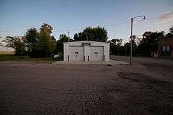
Rutland Cayuga Fire District in Cayuga | |
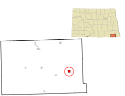 Location of Cayuga, North Dakota | |
| Coordinates: 46°4′29″N 97°23′12″W / 46.07472°N 97.38667°WCoordinates: 46°4′29″N 97°23′12″W / 46.07472°N 97.38667°W | |
| Country | United States |
| State | North Dakota |
| County | Sargent |
| Area[1] | |
| • Total | 0.99 sq mi (2.56 km2) |
| • Land | 0.99 sq mi (2.56 km2) |
| • Water | 0 sq mi (0 km2) |
| Elevation | 1,142 ft (348 m) |
| Population (2010)[2] | |
| • Total | 27 |
| • Estimate (2014)[3] | 27 |
| • Density | 27.3/sq mi (10.5/km2) |
| Time zone | Central (CST) (UTC-6) |
| • Summer (DST) | CDT (UTC-5) |
| ZIP code | 58013 |
| Area code(s) | 701 |
| FIPS code | 38-13020 |
| GNIS feature ID | 1028306[4] |
Cayuga is a city in Sargent County, North Dakota, United States. It sits on the banks of the Wild Rice River. The population was 27 at the 2010 census.[5] Cayuga was founded in 1887.
Geography
Cayuga is located at 46°4′29″N 97°23′12″W / 46.07472°N 97.38667°W (46.074752, -97.386725).[6]
According to the United States Census Bureau, the city has a total area of 0.99 square miles (2.56 km2), all of it land.[1]
Demographics
| Historical population | |||
|---|---|---|---|
| Census | Pop. | %± | |
| 1910 | 175 | — | |
| 1920 | 182 | 4.0% | |
| 1930 | 219 | 20.3% | |
| 1940 | 196 | −10.5% | |
| 1950 | 178 | −9.2% | |
| 1960 | 195 | 9.6% | |
| 1970 | 116 | −40.5% | |
| 1980 | 75 | −35.3% | |
| 1990 | 60 | −20.0% | |
| 2000 | 61 | 1.7% | |
| 2010 | 27 | −55.7% | |
| Est. 2015 | 26 | [7] | −3.7% |
| U.S. Decennial Census[8] 2014 Estimate[3] | |||
2010 census
As of the census[2] of 2010, there were 27 people, 13 households, and 10 families residing in the city. The population density was 27.3 inhabitants per square mile (10.5/km2). There were 26 housing units at an average density of 26.3 per square mile (10.2/km2). The racial makeup of the city was 100.0% White.
There were 13 households of which 7.7% had children under the age of 18 living with them, 76.9% were married couples living together, and 23.1% were non-families. 15.4% of all households were made up of individuals. The average household size was 2.08 and the average family size was 2.30.
The median age in the city was 55.5 years. 3.7% of residents were under the age of 18; 3.7% were between the ages of 18 and 24; 18.5% were from 25 to 44; 51.8% were from 45 to 64; and 22.2% were 65 years of age or older. The gender makeup of the city was 59.3% male and 40.7% female.
2000 census
As of the census of 2000, there were 61 people, 26 households, and 13 families residing in the city. The population density was 61.8 people per square mile (23.8/km²). There were 32 housing units at an average density of 32.4 per square mile (12.5/km²). The racial makeup of the city was 96.72% White, and 3.28% from two or more races.
There were 26 households out of which 23.1% had children under the age of 18 living with them, 46.2% were married couples living together, 3.8% had a female householder with no husband present, and 50.0% were non-families. 46.2% of all households were made up of individuals and 23.1% had someone living alone who was 65 years of age or older. The average household size was 2.35 and the average family size was 3.62.
In the city the population was spread out with 29.5% under the age of 18, 6.6% from 18 to 24, 26.2% from 25 to 44, 19.7% from 45 to 64, and 18.0% who were 65 years of age or older. The median age was 40 years. For every 100 females there were 96.8 males. For every 100 females age 18 and over, there were 115.0 males.
The median income for a household in the city was $26,875, and the median income for a family was $38,750. Males had a median income of $30,000 versus $27,500 for females. The per capita income for the city was $11,048. There were no families and 8.6% of the population living below the poverty line, including no under eighteens and 25.0% of those over 64.
Past Businesses

References
- 1 2 "US Gazetteer files 2010". United States Census Bureau. Archived from the original on 2012-01-24. Retrieved 2012-06-14.
- 1 2 "American FactFinder". United States Census Bureau. Retrieved 2012-06-14.
- 1 2 "Population Estimates". United States Census Bureau. Retrieved July 9, 2015.
- ↑ "US Board on Geographic Names". United States Geological Survey. 2007-10-25. Retrieved 2008-01-31.
- ↑ "2010 Census Redistricting Data (Public Law 94-171) Summary File". American FactFinder. United States Census Bureau. Archived from the original on 21 July 2011. Retrieved 2 May 2011.
- ↑ "US Gazetteer files: 2010, 2000, and 1990". United States Census Bureau. 2011-02-12. Retrieved 2011-04-23.
- ↑ "Annual Estimates of the Resident Population for Incorporated Places: April 1, 2010 to July 1, 2015". Retrieved July 2, 2016.
- ↑ United States Census Bureau. "Census of Population and Housing". Archived from the original on May 11, 2015. Retrieved January 30, 2014.
Municipalities and communities of Sargent County, North Dakota, United States | ||
|---|---|---|
| Cities | 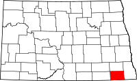 | |
| Townships | ||
| CDP | ||
| Unincorporated community |
| |
| Indian reservations | ||
| Footnotes | ‡This populated place also has portions in an adjacent county or counties | |