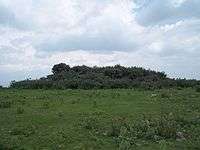
Cerro Mesa Ahumada
| Cerro Mesa Ahumada | |
|---|---|
.JPG) Cerro Mesa Ahumada | |
| Highest point | |
| Elevation | 2,250 m (7,380 ft) |
| Coordinates | 19°31′58″N 99°07′50″W / 19.53278°N 99.13056°WCoordinates: 19°31′58″N 99°07′50″W / 19.53278°N 99.13056°W |
| Naming | |
| Translation | Mesa Ahumada Hill (Spanish) |
| Geography | |
| Location | Tequixquiac, Apaxco, Huehuetoca; State of Mexico |
Cerro Mesa Ahumada (Mesa Ahumada Hill) or Cerro Colorado, is a hill located in the north of State of Mexico, in the borough of municipality of Tequixquiac and bordering the municipalities of Apaxco and Huehuetoca in the State of Mexico.[1] The hill has a height of 2,250 metres (7,380 ft) above sea level.[2] The mountain is located at a southern pass leading out of the Mezquital Valley.
Geology
Historically the small mountain had springs, but they have dried up. The land is volcanic rock, the age or edaphology is the durisol, phaeozem and vertisol, is soil classification.[3]
Archeological site

On the high mesa, there is archeological site named Los Mogotes.[4] This place was occupied by Otomian-Nahua tribes, here not exist only a few simple pre-Hispanic basements on the northwest side of the mesa, there are also petroglyphs on the rocks.[5] This site was discover in 1984 by local people, is located in hillside of Mesa to 2250 msnm. when archeologists from INAH visited this area.[6]
Los Mogotes has got 8 basements and small platform, these correspond to the so-called Coyotlatelco and Mazapa of late classic or epiclassical period (800-1000 a.C), this site was probably built for military activities for lookouts by Chichimeca people with astronomical observations, funeral activities and housing. The place has suffered looting, but were found some obsidian, stone utensils, human bones and mud bows.[7]
In east hillsides have got petroglyphs, are anthropomorphic figures of men and women, the engraving of a tonatiuh or tonalli, an ollin nahui, and concentric cross symbols that probably represent stars or locations.[8] The surroundings of the mesa was bound by many nomadic groups, soldiers and merchants, so it was a must watch and defense for the watchpoint because on the mesa the valleys are observed. In Tequixquiac (altepetl) many clashes occurred with Otomis, Aztecs, Tlaxcaltecs, Texcoco and Otumba people, the site on the mesa was necessary for watch people and warriors.[9]
Flora & fauna
Cerro Mesa Ahumada is Central Mexican Plateau, here there is a diversity in plants and animals of template and semi-desertic climate.[10][11]
The native plants are centuryplant, cholla, pickly pear, golden barrel, fencepost cactus, billberry cactus, Mexican creeping zinnia, creosote bush, pepicha, creeping false holly, tule, reed, barrel cactus, fern, trees as kidneywood tree, mesquite, netleaf oak, tepozán, needle bush, fruit trees as tejocote, capulin, white sapote and foreign trees as pirul and eucalypt.
Mesa Ahumada has a varied fauna: mammals are cacomistle, skunk, gopher, Virginia opossum, rabbit, Mexican gray squirrel, bat, Mexican hare, birds as turkey, colibri, turkey vulture, northern mockingbird, red warbler, rufous-crowned sparrow, lesser roadrunner, great horned owl, savannah sparrow, reptils as rattlesnake, pine snake, xincoyote, chirrionera snake, amphibians as axolotl, frog, toad and insects as red ant, bee, firefly, others. The extinct animals in this mountain since last century are coyote, bobcat and gray fox
Gallery
 Tigridia flower.
.jpg) Cholla (Cardón).
Cholla (Cardón)..jpg) Centuryplant (Maguey).
Centuryplant (Maguey)..jpg) Barrel cactus (Biznaga).
Barrel cactus (Biznaga)..jpg) Fern (Helecho).
Fern (Helecho)..jpg) Tree named huizache.
Tree named huizache. Lizard named xincoyote.
Environmental degradation
.jpg)
The cause is speculation the authorities of the state government of Mexico on the Cerro Mesa Ahumada prompted former state government through the company Wilk SA.[12] Despite what makes the act was repealed the proposal to create urban development plan because of high speculation was generated by the corruption of the PAN and PRI Tequixquiac and Apaxco mayors before state authorities.
See also
- Tula (Mesoamerican site)
- Cerro Ponzha
- Xaltocan
References
- ↑
- ↑
- ↑
- ↑ Plan de desarrollo municipal, Tequixquiac Page 9, May 22, 2016.
- ↑ Rodríguez Peláez, Maria Elena, Monografía municipal de Tequixquiac, Historia, Instituto Mexiquense de Cultura, Toluca de Lerdo, 1999. p.p. 78.
- ↑ El sitio arqueológico de Tequixquiac, México. López Warrio, Luis Alberto, Ortuño Cos, Francisco and Pulido Mendez, Salvador. INAH. 1985.
- ↑ El sitio arqueológico de Tequixquiac, México. López Warrio, Luis Alberto, Ortuño Cos, Francisco and Pulido Mendez, Salvador. INAH. 1985. pp. 35-38.
- ↑ El sitio arqueológico de Tequixquiac, México. López Warrio, Luis Alberto, Ortuño Cos, Francisco and Pulido Mendez, Salvador. INAH. 1985. pp. 39-41.
- ↑ Rodríguez Peláez, Maria Elena, Monografía municipal de Tequixquiac, Historia, Instituto Mexiquense de Cultura, Toluca de Lerdo, 1999. p.p. 81.
- ↑ Mi Ambiente
- ↑
- ↑
External links
| Wikimedia Commons has media related to Cerro Mesa Ahumada. |