Chaba River (Canada)
| Chaba River | |
|---|---|
|
Chaba River and Chaba Icefield | |
| Country |
|
| Basin | |
| Main source |
Chaba Icefield 1,597 m (5,240 ft) 52°14′49″N 117°40′52″W / 52.24694°N 117.68111°W |
| River mouth |
Athabasca River 1,380 m (4,530 ft) 52°25′05″N 117°39′38″W / 52.41806°N 117.66056°WCoordinates: 52°25′05″N 117°39′38″W / 52.41806°N 117.66056°W |
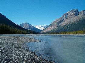
The Chaba River is a short river in western Alberta, Canada. It flows from the Canadian Rockies, and joins the Athabasca River.[1]
The Chaba River is a major tributary of the Athabasca. The Chaba is fed by the glacial melt originating in the Chaba Icefield, comprising Chaba Peak, as well as Listening and Sundial Peaks. A small glacier on Mount Quincy also contributes to the Chaba. The river was given its name by A. P. Coleman, a geologist born in Eastern Canada in 1852.[2] He stated there "were endless beaver dams and trees" along the river, and named it after the Stoney Indian word for beavers."[3]
References
- ↑ Mussio Ventures. Central Alberta Backroad Mapbook. Burnaby: Backroad Mapbooks (2002)
- ↑ Coleman, A.P. (1895). "Mount Brown and the Sources of the Athabasca". The Geographical Journal. Royal Geographical Society. 5: 53–61. doi:10.2307/1773875. Retrieved 2009-07-10.
- ↑ Karamitsanis, Aphrodite (1991). Place Names of Alberta, Volume 1. Calgary: University of Calgary Press, pg. 45
See also
This article is issued from Wikipedia - version of the 11/4/2016. The text is available under the Creative Commons Attribution/Share Alike but additional terms may apply for the media files.