Chickasawhay River
| Chickasawhay River | |
|---|---|
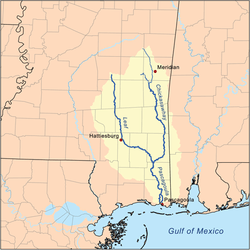 Map of the Pascagoula River and watershed | |
| Basin | |
| Main source |
Confluence of Okatibbee Creek and Chunky River in Clarke County, Mississippi 244 ft (74 m) 32°10′58″N 88°49′19″W / 32.1827778°N 88.8219444°W |
| River mouth |
Confluence with the Leaf River forming the Pascagoula River 43 ft (13 m) 30°58′57″N 88°43′49″W / 30.9825°N 88.7302778°WCoordinates: 30°58′57″N 88°43′49″W / 30.9825°N 88.7302778°W |
| Progression | Chickasawhay River → Pascagoula River → Gulf of Mexico |
| Physical characteristics | |
| Length | 210 mi (340 km) |
| Features | |
| GNIS ID | 692890 |
The Chickasawhay River is a river, about 210 miles (340 km) long, in southeastern Mississippi in the United States. It is a principal tributary of the Pascagoula River, which flows to the Gulf of Mexico.[1] The Chickasawhay's tributaries also drain a portion of western Alabama. The name "Chickasawhay" comes from the Choctaw word chikashsha-ahi, literally "Chickasaw potato".[2]
Course
The Chickasawhay is formed by the confluence of the Chunky River and Okatibbee Creek at Enterprise in northwestern Clarke County and flows generally southward through Clarke, Wayne and Greene Counties into northern George County, where it meets the Leaf River to form the Pascagoula River. The Chickasawhay flows past the towns of Stonewall, Quitman, Shubuta, Waynesboro, and Leakesville.
See also
References
- ↑ "Chickasawhay River". Geographic Names Information System. United States Geological Survey. Retrieved 2015-09-20.
- ↑ Bright, William (2004). Native American placenames of the United States. University of Oklahoma Press. p. 97. ISBN 978-0-8061-3598-4. Retrieved 14 April 2011.