George County, Mississippi
| George County, Mississippi | |
|---|---|
 George County courthouse in Lucedale | |
 Location in the U.S. state of Mississippi | |
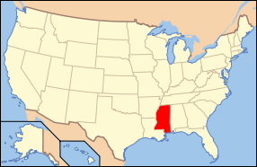 Mississippi's location in the U.S. | |
| Founded | 1910 |
| Named for | James Z. George |
| Seat | Lucedale |
| Largest city | Lucedale |
| Area | |
| • Total | 484 sq mi (1,254 km2) |
| • Land | 479 sq mi (1,241 km2) |
| • Water | 4.9 sq mi (13 km2), 1.0% |
| Population | |
| • (2010) | 22,578 |
| • Density | 47/sq mi (18/km²) |
| Congressional district | 4th |
| Time zone | Central: UTC-6/-5 |
| Website |
www |
George County is a county located in the U.S. state of Mississippi. As of the 2010 census, the population was 22,578.[1] Its county seat is Lucedale.[2] The county is named for James Z. George, US Senator from Mississippi. It is a dry county.
George County is included in the Gulfport-Biloxi-Pascagoula, MS Metropolitan Statistical Area.
Geography
According to the U.S. Census Bureau, the county has a total area of 484 square miles (1,250 km2), of which 479 square miles (1,240 km2) is land and 4.9 square miles (13 km2) (1.0%) is water.[3]
Major highways
Adjacent counties
- Greene County (north)
- Mobile County, Alabama (east)
- Jackson County (south)
- Stone County (west)
- Perry County (northwest)
National protected area
- De Soto National Forest (part)
Demographics
| Historical population | |||
|---|---|---|---|
| Census | Pop. | %± | |
| 1910 | 6,599 | — | |
| 1920 | 5,564 | −15.7% | |
| 1930 | 7,523 | 35.2% | |
| 1940 | 8,704 | 15.7% | |
| 1950 | 10,012 | 15.0% | |
| 1960 | 11,098 | 10.8% | |
| 1970 | 12,459 | 12.3% | |
| 1980 | 15,927 | 27.8% | |
| 1990 | 16,673 | 4.7% | |
| 2000 | 19,144 | 14.8% | |
| 2010 | 22,578 | 17.9% | |
| Est. 2015 | 23,373 | [4] | 3.5% |
| U.S. Decennial Census[5] 1790-1960[6] 1900-1990[7] 1990-2000[8] 2010-2013[1] | |||
As of the census[9] of 2000, there were 19,144 people, 6,742 households, and 5,305 families residing in the county. The population density was 40 people per square mile (15/km²). There were 7,513 housing units at an average density of 16 per square mile (6/km²). The racial makeup of the county was 89.38% White, 8.82% African American, 0.24% Native American, 0.16% Asian, 0.84% from other races, and 0.57% from two or more races. 1.60% of the population were Hispanic or Latino of any race.
There were 6,742 households out of which 38.70% had children under the age of 18 living with them, 64.00% were married couples living together, 10.40% had a female householder with no husband present, and 21.30% were non-families. 19.10% of all households were made up of individuals and 8.20% had someone living alone who was 65 years of age or older. The average household size was 2.78 and the average family size was 3.17.
In the county the population was spread out with 29.20% under the age of 18, 9.40% from 18 to 24, 28.60% from 25 to 44, 21.90% from 45 to 64, and 10.90% who were 65 years of age or older. The median age was 33 years. For every 100 females there were 100.60 males. For every 100 females age 18 and over, there were 98.60 males.
The median income for a household in the county was $34,730, and the median income for a family was $39,386. Males had a median income of $33,575 versus $20,542 for females. The per capita income for the county was $14,337. About 13.00% of families and 16.70% of the population were below the poverty line, including 20.80% of those under age 18 and 20.20% of those age 65 or over.
Politics
The county has gone solidly Republican in the last five Presidential elections.[10] In past Presidential elections third party candidates sometimes did well here. In 1968 George Wallace won the county with over 90% of the vote,[11] which was the second highest percentage he received in any county. In 1988 the county gave David Duke 4.21%, which was the highest percentage he received. In that election it also gave more support to Lenora Fulani than she received in most of the nation. In 2012, President Obama only received 14% of the vote.[12]
The county is located in Mississippi's 4th congressional district, which has a Cook Partisan Voting Index of R+16 and is represented by Republican Steven Palazzo.
Communities
City
- Lucedale (county seat)
Unincorporated places
- Agricola
- Basin
- Benndale
- Bexley
- Buzzard Roost
- Crossroads
- Merrill
- Rocky Creek
- Shipman
See also
References
- 1 2 "State & County QuickFacts". United States Census Bureau. Retrieved September 3, 2013.
- ↑ "Find a County". National Association of Counties. Archived from the original on May 31, 2011. Retrieved 2011-06-07.
- ↑ "2010 Census Gazetteer Files". United States Census Bureau. August 22, 2012. Retrieved November 3, 2014.
- ↑ "County Totals Dataset: Population, Population Change and Estimated Components of Population Change: April 1, 2010 to July 1, 2015". Retrieved July 2, 2016.
- ↑ "U.S. Decennial Census". United States Census Bureau. Archived from the original on May 11, 2015. Retrieved November 3, 2014.
- ↑ "Historical Census Browser". University of Virginia Library. Retrieved November 3, 2014.
- ↑ "Population of Counties by Decennial Census: 1900 to 1990". United States Census Bureau. Retrieved November 3, 2014.
- ↑ "Census 2000 PHC-T-4. Ranking Tables for Counties: 1990 and 2000" (PDF). United States Census Bureau. Retrieved November 3, 2014.
- ↑ "American FactFinder". United States Census Bureau. Archived from the original on September 11, 2013. Retrieved 2008-01-31.
- ↑ The New York Times Electoral Map (Zoom in on Mississippi)
- ↑ David Leip's Presidential Election Atlas Statistics for 1968
- ↑ David Leip's Presidential Election Atlas Statistics for 1988
External links
 |
Perry County | Greene County | | |
| Stone County | |
Mobile County, Alabama | ||
| ||||
| | ||||
| Jackson County |
Municipalities and communities of George County, Mississippi, United States | ||
|---|---|---|
| Cities | | |
| Unincorporated communities |
| |
.svg.png)
Coordinates: 30°52′N 88°38′W / 30.87°N 88.64°W