Chifley, Australian Capital Territory
| Chifley Canberra, Australian Capital Territory | |||||||||||||
|---|---|---|---|---|---|---|---|---|---|---|---|---|---|
 | |||||||||||||
| Population | 2,489 (2011 census)[1] | ||||||||||||
| • Density | 1,560/km2 (4,030/sq mi) | ||||||||||||
| Established | 1966 | ||||||||||||
| Postcode(s) | 2606 | ||||||||||||
| Area | 1.6 km2 (0.6 sq mi) | ||||||||||||
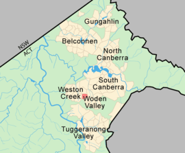
| District | Woden Valley | ||||||||||||
| Territory electorate(s) | Murrumbidgee | ||||||||||||
| Federal Division(s) | Canberra | ||||||||||||
| |||||||||||||
Chifley (postcode: 2606) is a suburb of Canberra, Australia, in the district of Woden Valley. The suburb's area is 1.6 square kilometres (0.62 sq mi).
It was named after Joseph Benedict Chifley, Prime Minister of Australia from July 1945 to December 1949. The streets of Chifley are named for scientists and educationalists.[2]
It is next to the suburbs of Pearce, Lyons and Phillip. Behind it stands Mount Taylor, which is a nature park. It is bordered by Hindmarsh Drive and Melrose Drive. A local shopping centre and Chifley Neighbourhood Oval are located in the suburb.
History
Chifley was established on 12 May 1966, which was around the same time when the Woden Valley was also established, thus making it one of the original settlement spots in the sourtern part of Canberra.[3] This gazzetal Districts Ordinance 1966 No. 5 (Cth) which, after the enactment of the Australian Capital Territory (Self-Government) Act 1988 (Cth), became the Districts Act 1966 No. 5 (ACT). This Act was subsequently repealed by the ACT Government, which this also happened with the rest of the suburbs of Woden. Construction in the suburb itself also began in 1966, with 795 houses and 156 flats built to accommodate approximately 3,000 people. Most of the streets in Chifley were named after academics.[4]
The Canberra bushfires of 2003 engulfed multiple parts of Canberra on 18 January 2003 and also reached the Mount Taylor Nature Reserve which Chifley borders with. Thankfully the fires did not reach into Chifley or caused minimal damage in the suburb. in 2014, ACT Disability Minister Joy Burch, alongside Canberra Raiders coach Ricky Stuart launched a new respite centre project for children with disabilities. The facility will serve 30 to 40 families annually, and the ACT Government has funded the project with $1 million.[5]
Geology
Chifley is underlaid by Silurian age Deakin Volcanics rhyodacite which are coloured green-grey, red or purple.[6][7]
Demographics
On Census night of 2011, Chifley had a total population of 2,489 people: 50.6% were males and 49.4% were females. The median age of people in Chifley was 36 years, above the median age for Canberra of 34. The median individual income for Chifley was $861. Median household income was $1,633 and the Median income for families was $2,117, which was above the Australian average.[1]
Around 68.4% of the residents in Chifley were born in Australia. The three main countries of birth for those born overseas were India, 4.7%, England, 3.5% and China, 1.4%. The most popular religious affiliations in descending order were no religion, Catholic, Anglican, the Uniting Church and Islam.[1]
Politics
Chifley is located in the federal House of Representatives electorate of Canberra, which is the largest division in the Australian Capital Territory. The electorate of Canberra is represented by Gai Brodtmann of the Australian Labor Party.
Chifley is located in the ACT Legislative Assembly electorate of Murrumbidgee. The electorate elects five members on the basis of proportional representation.
Suburb amenities
Shops and churches
Chifley has a small local shopping centre located on Eggleston Crescent. The shopping centre consists of a supermarket, a bakery, a restaurant, a podiatrist, chiropractor, and a local liquor store. Chifley only has one church which is located at Maclaurin Crescent, known as the Calvary Chapel.[8]
Recreation
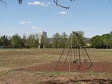
Local playground and basketball courts are located there, a graffiti wall, and the Chifley Neighbourhood Oval. There are public BBQs at the playground.
Education
A small preschool is located in the suburb. The suburb once had a primary school originally named as Chifley Primary School, which opened in 1966. The school closed in 1989 and was renamed Melrose Primary School, until its closure again in 2006.[9]
See also
References
- 1 2 3 Australian Bureau of Statistics (31 October 2012). "Chifley (State Suburb)". 2011 Census QuickStats. Retrieved 9 February 2014.
- ↑ "Suburb Name search results". ACT Environment and Sustainable Development. Retrieved 9 February 2014.
- ↑ "Districts Ordinance 1966 No. 5 (Cth)". Australian Capital Territory Numbered Ordinances. AustLII. Retrieved 18 December 2013.
- ↑ "Distinguished name for suburb". The Canberra Times. Canberra, A.C.T.: National Library of Australia. 24 January 1980. p. 12.
- ↑ McIlroy, Tom (3 December 2014). "Raiders coach Ricky Stuart and Joy Burch launch new disability centre project". The Canberra Times. Retrieved 24 December 2014.
- ↑ Gardner, D.E. ( 1974 ): Geological observations at several construction sites, at Canberra (Northside) and Phillip, ACT 1967-68. Bureau of Mineral Resources, Geology and Geophysics.
- ↑ Henderson, G. A. M.; Matveev, G. (1980). Geology of Canberra, Queanbeyan and Environs (Map). 1:50000.
- ↑ "Contact Form - Connect with You". Chilfey, Canberra ACT: Calvary Chapel. Retrieved 12 November 2014.
- ↑ "Schools in the ACT". ACT Government. 20 October 2014. Retrieved 24 December 2014.
Coordinates: 35°21′04″S 149°04′40″E / 35.35111°S 149.07778°E