Chip Lake (Alberta)
| Chip Lake | |
|---|---|
 A frozen Chip Lake seen from the north shore | |
| Location | Yellowhead County, Alberta |
| Coordinates | 53°40′00″N 115°23′00″W / 53.6667°N 115.3833°WCoordinates: 53°40′00″N 115°23′00″W / 53.6667°N 115.3833°W |
| Primary inflows | Lobstick River, Poison Creek |
| Primary outflows | Lobstick River |
| Basin countries | Canada |
| Surface area | 73 km2 (28 sq mi) |
| Surface elevation | 792 m (2,598 ft) |
| Settlements | Chip Lake |
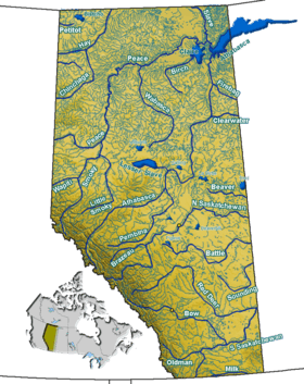
Chip Lake is a large lake in west-central Alberta. The Lobstick River flows through the lake. It in turn is a tributary of the Pembina River, which eventually flows into the Athabasca River.
Poison Creek flows into the north-west corner of Chip Lake. It drains Beta Lake and Sunset Lake. Prior to entering Chip Lake, the Lobstick River takes on Brule and Little Brule Creeks.
The Yellowhead passes along the south shore of Chip Lake. The small town of Wildwood can also be found on the lake's south shore.[1]
References
- ↑ Mussio Ventures. Central Alberta Backroad Mapbook. Burnaby: Backroad Mapbooks (2002), pp. 31-32
See also
This article is issued from Wikipedia - version of the 9/4/2015. The text is available under the Creative Commons Attribution/Share Alike but additional terms may apply for the media files.