Chonos Archipelago
| Native name: <span class="nickname" ">Archipiélago de Chonos | |
|---|---|
 Chonos Archipelago can be seen in the upper right portion of the image. | |
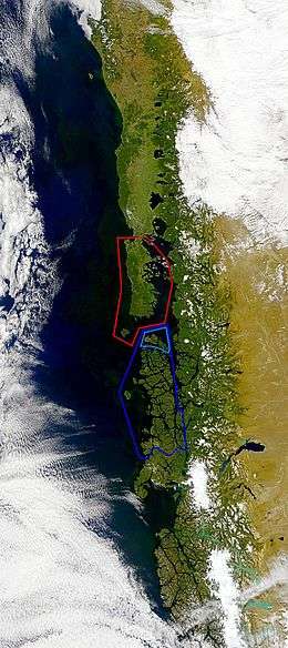 Chonos Archipelago is marked with dark blue, Guaitecas Archipelago with light blue and Chiloé Archipelago is marked with red | |
| Geography | |
| Coordinates | 45°08′00″S 73°57′00″W / 45.1333°S 73.95°WCoordinates: 45°08′00″S 73°57′00″W / 45.1333°S 73.95°W |
| Adjacent bodies of water | Pacific Ocean |
| Administration | |
| Region | Aisén |
| Additional information | |
| NGA UFI=-877176 | |
Chonos Archipelago is a series of low mountainous elongated islands with deep bays, traces of a submerged Chilean Coast Range. Most of the islands are forested with little or no human settlement. The deep Moraleda Channel separates the islands of the Chonos Archipelago from the mainland of Chile and from Magdalena Island.
The largest islands are Melchor Island, Benjamin Island, Traiguen Island, Riveros Island, Cuptana Island, James Island, Victoria Island, Simpson Island (Chile), Level Island, Luz Island.
Far out in the Pacific is Guamblin Island with the Isla Guamblin National Park. The National park comprises about 106 km². Blue whales can often be seen here.
Some groups of islands are grouped into minor archipelagoes such as the Guaitecas Archipelago. Guaitecas Archipelago have its own municipality and possesses the only settlement in the archipelago, Melinka. All islands are part of the Aisén Region.
See also
External links
- Islands of Chile @ United Nations Environment Programme
- World island information @ WorldIslandInfo.com
- South America Island High Points above 1000 meters
- United States Hydrographic Office, South America Pilot (1916)