Clearing, Chicago
| Clearing | |
|---|---|
| Community area | |
| Community Area 64 - Clearing | |
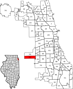 Location within the city of Chicago | |
| Coordinates: 41°46.8′N 87°45.6′W / 41.7800°N 87.7600°WCoordinates: 41°46.8′N 87°45.6′W / 41.7800°N 87.7600°W | |
| Country | United States |
| State | Illinois |
| County | Cook |
| City | Chicago |
| Neighborhoods |
list
|
| Area | |
| • Total | 2.56 sq mi (6.63 km2) |
| Population (2010) | |
| • Total | 23,139 |
| • Density | 9,000/sq mi (3,500/km2) |
| Demographics2010[1] | |
| • White | 51.52% |
| • Black | 1.22% |
| • Hispanic | 45.31% |
| • Asian | 0.92% |
| • Other | 1.04% |
| Time zone | CST (UTC-6) |
| • Summer (DST) | CDT (UTC-5) |
| ZIP Codes | parts of 60629 and 60638 |
| Median income[2] | $54,123 |
| Source: U.S. Census, Record Information Services | |
Clearing, one of the 77 official community areas, is located on the southwest side of the city of Chicago, Illinois. The southern portion of Chicago Midway International Airport is located within this community area.
History
The history of Clearing begins shrouded in mystery. An anomalous subdivision began showing up in maps as early as 1870. Local author and historian Robert Hill calls this the "Lost Village". This subdivision appears between present day Nashville and Narragansett and between 59th and 63rd streets. Though when names appear, they are different from what they are currently. For example, Narragansett is Major.
The area gets its name from the fact that farm goods from the area were "cleared" (delivered) through the airport and railroad yards. Clearing was first incorporated as a town in 1912, within the Township of Stickney. The Clearing area quickly became a part of Chicago in 1915 because the growing population needed services provided by the city. It is bordered on the west by Harlem Avenue, on the east by railroad tracks just east of Cicero Ave., to the North by 59th street and to the south by 65th street. The southern portion of Midway Airport is in Clearing.
The Clearing Industrial District was founded in 1907.
Lawler Park (6.2-acre (25,000 m2)), is located in Clearing. Created in 1947, Lawler Park is home to organized Little League softball, a brick recreation building, sandboxes, and other playground equipment.[3] Hale Park and Nathan Hale Elementary School, at 61st and Melvina, are also located in Clearing.[4] Hale Park is home to an outdoor swimming pool, field house, ball fields, and playground equipment.[5]
Neighborhoods
Chrysler Village
Chrysler Village is on the eastern edge of the Chicago neighborhood of Clearing nestled between Midway Airport and the Clearing Industrial District. Beginning at Lavergne Avenue on the east and extending to Long Avenue on the West the sturdy brick single family, duplex and townhouse homes surround Lawler Park and were constructed in 1943 during World War II to house the Chrysler Defense Plant workers building the B29 Bomber Engines in the huge plant later housing the Ford Aircraft Engine Division, builders of the B52 Bomber Engines and now known as Ford City.
| Historical population | |||
|---|---|---|---|
| Census | Pop. | %± | |
| 1930 | 5,434 | — | |
| 1940 | 6,068 | 11.7% | |
| 1950 | 10,591 | 74.5% | |
| 1960 | 18,797 | 77.5% | |
| 1970 | 24,527 | 30.5% | |
| 1980 | 22,584 | −7.9% | |
| 1990 | 21,490 | −4.8% | |
| 2000 | 22,331 | 3.9% | |
| 2010 | 23,139 | 3.6% | |
| [6] | |||
References
- ↑ Paral, Rob. "Chicago Demographics Data". Archived from the original on 2 June 2013. Retrieved 21 September 2012.
- ↑ Paral, Rob. "Chicago Census Data". Archived from the original on 5 October 2013. Retrieved 21 September 2012.
- ↑ Chicago Park District http://www.chicagoparkdistrict.com/index.cfm/fuseaction/parks.detail/object_id/3852A50E-AB4D-4542-B8AD-B4F10BA1F3C4.cfm
- ↑ Nathan Hale Elementary School http://haleschool.org
- ↑ Chicago Park District http://www.chicagoparkdistrict.com/index.cfm/fuseaction/parks.detail/object_id/9DBA46E9-97B2-4D8B-BA00-7C97C3CF0085.cfm
- ↑ Paral, Rob. "Chicago Community Areas Historical Data". Archived from the original on 18 March 2013. Retrieved 3 September 2012.
External links
 |
Garfield Ridge, Chicago | West Elsdon, Chicago |
| ||||
| Summit, Illinois | |
||||||
| |
|||||||
| |
West Lawn, Chicago | ||||||
| Bedford Park, Illinois |