Circleville, Kansas
| Circleville, Kansas | |
|---|---|
| City | |
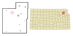 Location within Jackson County and Kansas | |
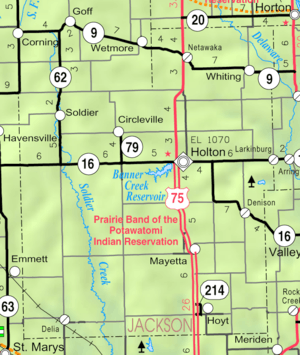 KDOT map of Jackson County (legend) | |
| Coordinates: 39°30′32″N 95°51′29″W / 39.50889°N 95.85806°WCoordinates: 39°30′32″N 95°51′29″W / 39.50889°N 95.85806°W | |
| Country | United States |
| State | Kansas |
| County | Jackson |
| Area[1] | |
| • Total | 0.26 sq mi (0.67 km2) |
| • Land | 0.26 sq mi (0.67 km2) |
| • Water | 0 sq mi (0 km2) |
| Elevation | 1,135 ft (346 m) |
| Population (2010)[2] | |
| • Total | 170 |
| • Estimate (2012[3]) | 170 |
| • Density | 650/sq mi (250/km2) |
| Time zone | Central (CST) (UTC-6) |
| • Summer (DST) | CDT (UTC-5) |
| ZIP code | 66416 |
| Area code | 785 |
| FIPS code | 20-13375 [4] |
| GNIS feature ID | 0473452 [5] |
Circleville is a city in Jackson County, Kansas, United States. As of the 2010 census, the city population was 170.[6]
History
Circleville was founded in 1863.[7] It may have been named after Circleville, Ohio,[8] or because the town "circled" around the prairie.[9]
Geography
Circleville is located at 39°30′32″N 95°51′29″W / 39.50889°N 95.85806°W (39.508927, -95.858045).[10] According to the United States Census Bureau, the city has a total area of 0.26 square miles (0.67 km2), all of it land.[1]
Climate
This climatic region is typified by large seasonal temperature differences, with warm to hot (and often humid) summers and cold (sometimes severely cold) winters. According to the Köppen Climate Classification system, Circleville has a humid subtropical climate, abbreviated "Cfa" on climate maps.[11]
Demographics
| Historical population | |||
|---|---|---|---|
| Census | Pop. | %± | |
| 1880 | 122 | — | |
| 1890 | 215 | 76.2% | |
| 1900 | 223 | 3.7% | |
| 1910 | 265 | 18.8% | |
| 1920 | 226 | −14.7% | |
| 1930 | 211 | −6.6% | |
| 1940 | 216 | 2.4% | |
| 1950 | 169 | −21.8% | |
| 1960 | 151 | −10.7% | |
| 1970 | 178 | 17.9% | |
| 1980 | 164 | −7.9% | |
| 1990 | 153 | −6.7% | |
| 2000 | 185 | 20.9% | |
| 2010 | 170 | −8.1% | |
| Est. 2015 | 168 | [12] | −1.2% |
| U.S. Decennial Census | |||
Circleville is part of the Topeka, Kansas Metropolitan Statistical Area.
2010 census
As of the census[2] of 2010, there were 170 people, 69 households, and 47 families residing in the city. The population density was 653.8 inhabitants per square mile (252.4/km2). There were 77 housing units at an average density of 296.2 per square mile (114.4/km2). The racial makeup of the city was 95.3% White, 0.6% African American, and 4.1% Native American. Hispanic or Latino of any race were 1.2% of the population.
There were 69 households of which 34.8% had children under the age of 18 living with them, 52.2% were married couples living together, 11.6% had a female householder with no husband present, 4.3% had a male householder with no wife present, and 31.9% were non-families. 26.1% of all households were made up of individuals and 11.6% had someone living alone who was 65 years of age or older. The average household size was 2.46 and the average family size was 2.83.
The median age in the city was 36.5 years. 28.2% of residents were under the age of 18; 8.2% were between the ages of 18 and 24; 20.6% were from 25 to 44; 26.5% were from 45 to 64; and 16.5% were 65 years of age or older. The gender makeup of the city was 53.5% male and 46.5% female.
2000 census
As of the census[4] of 2000, there were 185 people, 77 households, and 49 families residing in the city. The population density was 1,020.3 people per square mile (396.8/km²). There were 80 housing units at an average density of 441.2 per square mile (171.6/km²). The racial makeup of the city was 92.97% White, 2.70% Native American, 0.54% Asian, 0.54% from other races, and 3.24% from two or more races. Hispanic or Latino of any race were 2.70% of the population.
There were 77 households out of which 40.3% had children under the age of 18 living with them, 51.9% were married couples living together, 7.8% had a female householder with no husband present, and 35.1% were non-families. 32.5% of all households were made up of individuals and 10.4% had someone living alone who was 65 years of age or older. The average household size was 2.40 and the average family size was 3.00.
In the city the population was spread out with 30.3% under the age of 18, 7.6% from 18 to 24, 30.3% from 25 to 44, 19.5% from 45 to 64, and 12.4% who were 65 years of age or older. The median age was 31 years. For every 100 females there were 110.2 males. For every 100 females age 18 and over, there were 87.0 males.
The median income for a household in the city was $32,885, and the median income for a family was $34,750. Males had a median income of $22,083 versus $20,000 for females. The per capita income for the city was $14,293. About 12.2% of families and 10.9% of the population were below the poverty line, including 15.7% of those under the age of eighteen and 16.0% of those sixty five or over.
References
- 1 2 "US Gazetteer files 2010". United States Census Bureau. Archived from the original on 2012-01-24. Retrieved 2012-07-06.
- 1 2 "American FactFinder". United States Census Bureau. Retrieved 2012-07-06.
- ↑ "Population Estimates". United States Census Bureau. Archived from the original on 2013-06-17. Retrieved 2013-05-29.
- 1 2 "American FactFinder". United States Census Bureau. Archived from the original on 2013-09-11. Retrieved 2008-01-31.
- ↑ "US Board on Geographic Names". United States Geological Survey. 2007-10-25. Retrieved 2008-01-31.
- ↑ "2010 City Population and Housing Occupancy Status". U.S. Census Bureau. Archived from the original on July 21, 2011. Retrieved March 17, 2012.
- ↑ Blackmar, Frank Wilson (1912). Kansas: A Cyclopedia of State History, Embracing Events, Institutions, Industries, Counties, Cities, Towns, Prominent Persons, Etc. Standard Publishing Company. p. 350.
- ↑ Capace, Nancy (1 June 2000). Encyclopedia of Kansas. North American Book Dist LLC. p. 151. ISBN 978-0-403-09312-0.
- ↑ Barr, Elizabeth N. (1907). Business directory and history of Jackson County. p. 78.
- ↑ "US Gazetteer files: 2010, 2000, and 1990". United States Census Bureau. 2011-02-12. Retrieved 2011-04-23.
- ↑ Climate Summary for Circleville, Kansas
- ↑ "Annual Estimates of the Resident Population for Incorporated Places: April 1, 2010 to July 1, 2015". Retrieved July 2, 2016.
External links
| Wikimedia Commons has media related to Circleville, Kansas. |
- City
- Schools
- USD 335, local school district
- Maps
- Circleville City Map, KDOT
Municipalities and communities of Jackson County, Kansas, United States | ||
|---|---|---|
| Cities | 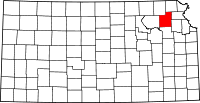 | |
| Unincorporated communities | ||
| Indian reservations | ||
| Townships | ||
| Footnotes | ‡This populated place also has portions in an adjacent county or counties | |