Circleville Township, Pickaway County, Ohio
| Circleville Township, Pickaway County, Ohio | |
|---|---|
| Township | |
|
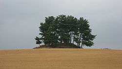
The Luthor List Mound, a historic site in the township | |
 Location of Circleville Township in Pickaway County | |
| Coordinates: 39°36′30″N 82°56′56″W / 39.60833°N 82.94889°WCoordinates: 39°36′30″N 82°56′56″W / 39.60833°N 82.94889°W | |
| Country | United States |
| State | Ohio |
| County | Pickaway |
| Area | |
| • Total | 10.1 sq mi (26.2 km2) |
| • Land | 9.9 sq mi (25.7 km2) |
| • Water | 0.2 sq mi (0.6 km2) |
| Elevation[1] | 692 ft (211 m) |
| Population (2000) | |
| • Total | 2,300 |
| • Density | 232.2/sq mi (89.7/km2) |
| Time zone | Eastern (EST) (UTC-5) |
| • Summer (DST) | EDT (UTC-4) |
| ZIP code | 43113 |
| Area code(s) | 740 |
| FIPS code | 39-15077[2] |
| GNIS feature ID | 1086792[1] |
Circleville Township is one of the fifteen townships of Pickaway County, Ohio, United States. The 2000 census found 2,300 people in the township.[3]
Geography
Located in the eastern part of the county, it borders the following townships:
- Walnut Township - north
- Washington Township - east
- Perry Township - south
- Wayne Township - southwest
- Jackson Township - northwest
Central Circleville Township is occupied by the city of Circleville, the county seat of Pickaway County. In southwestern Circleville Township is located the census-designated place of Logan Elm Village.
Name and history
It is the only Circleville Township statewide.[4]
Circleville Township was organized in 1833.[5]
Government
The township is governed by a three-member board of trustees, who are elected in November of odd-numbered years to a four-year term beginning on the following January 1. Two are elected in the year after the presidential election and one is elected in the year before it. There is also an elected township fiscal officer,[6] who serves a four-year term beginning on April 1 of the year after the election, which is held in November of the year before the presidential election. Vacancies in the fiscal officership or on the board of trustees are filled by the remaining trustees.
References
- 1 2 "US Board on Geographic Names". United States Geological Survey. 2007-10-25. Retrieved 2008-01-31.
- ↑ "American FactFinder". United States Census Bureau. Archived from the original on 2013-09-11. Retrieved 2008-01-31.
- ↑ Pickaway County, Ohio — Population by Places Estimates Ohio State University, 2007. Accessed 15 May 2007.
- ↑ "Detailed map of Ohio" (PDF). United States Census Bureau. 2000. Retrieved 2007-02-16.
- ↑ Kilbourn, John (1833). The Ohio Gazetteer, or, a Topographical Dictionary. Scott and Wright. p. 137. Retrieved 12 December 2013.
- ↑ §503.24, §505.01, and §507.01 of the Ohio Revised Code. Accessed 4/30/2009.
External links
Municipalities and communities of Pickaway County, Ohio, United States | ||
|---|---|---|
| City | 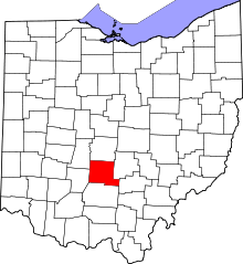 | |
| Villages | ||
| Townships | ||
| CDPs | ||
| Unincorporated communities | ||
| Ghost town | ||
| Footnotes | ‡This populated place also has portions in an adjacent county or counties | |