Cliffside, North Carolina
| Cliffside, North Carolina | |
|---|---|
| Unincorporated community | |
 Cliffside, North Carolina  Cliffside, North Carolina | |
| Coordinates: 35°14′17″N 81°46′11″W / 35.23806°N 81.76972°WCoordinates: 35°14′17″N 81°46′11″W / 35.23806°N 81.76972°W | |
| Country | United States |
| State | North Carolina |
| County | Rutherford |
| Area[1] | |
| • Total | 2.328 sq mi (6.03 km2) |
| • Land | 2.328 sq mi (6.03 km2) |
| • Water | 0 sq mi (0 km2) |
| Elevation | 738 ft (225 m) |
| Population (2010)[2] | |
| • Total | 611 |
| • Density | 260/sq mi (100/km2) |
| Time zone | Eastern (EST) (UTC-5) |
| • Summer (DST) | EDT (UTC-4) |
| ZIP code | 28024 |
| Area code(s) | 828 |
| GNIS feature ID | 1019699[3] |
Cliffside is an unincorporated community and census-designated place (CDP) in Rutherford County, North Carolina, United States.[3] Its population was 611 as of the 2010 census. Cliffside has a post office with ZIP code 28024.[4][5] U.S. Route 221 Alternate and North Carolina Highway 120 pass through the community.
Cliffside Public School was added to the National Register of Historic Places in 1998.[6]
References
- ↑ "US Gazetteer files: 2010, 2000, and 1990". United States Census Bureau. 2011-02-12. Retrieved 2011-04-23.
- ↑ "American FactFinder". United States Census Bureau. Archived from the original on 2013-09-11. Retrieved 2011-05-14.
- 1 2 "Cliffside". Geographic Names Information System. United States Geological Survey.
- ↑ United States Postal Service (2012). "USPS - Look Up a ZIP Code". Retrieved 2012-02-15.
- ↑ "Postmaster Finder - Post Offices by ZIP Code". United States Postal Service. Retrieved March 6, 2014.
- ↑ National Park Service (2010-07-09). "National Register Information System". National Register of Historic Places. National Park Service.
Municipalities and communities of Rutherford County, North Carolina, United States | ||
|---|---|---|
| Towns | 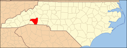 | |
| Village | ||
| CDPs | ||
| Unincorporated communities |
| |
This article is issued from Wikipedia - version of the 11/26/2016. The text is available under the Creative Commons Attribution/Share Alike but additional terms may apply for the media files.