Coaldale, Bedford County, Pennsylvania
| Coaldale, Pennsylvania Six Mile Run | |
|---|---|
| Borough | |
|
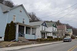
Houses on Main Street | |
 Coaldale | |
| Coordinates: 40°10′04″N 78°12′58″W / 40.16778°N 78.21611°WCoordinates: 40°10′04″N 78°12′58″W / 40.16778°N 78.21611°W | |
| Country | United States |
| State | Pennsylvania |
| County | Bedford |
| Settled | 1855 |
| Incorporated | 1865 |
| Government | |
| • Type | Borough Council |
| Area | |
| • Total | 0.09 sq mi (0.2 km2) |
| • Land | 0.09 sq mi (0.2 km2) |
| • Water | 0.0 sq mi (0 km2) |
| Elevation | 1,939 ft (591 m) |
| Population (2010) | |
| • Total | 161 |
| • Density | 4,773/sq mi (1,842.7/km2) |
| Time zone | Eastern (EST) (UTC-5) |
| • Summer (DST) | EDT (UTC-4) |
| ZIP code | 16679 |
| Area code(s) | 814 |
Coaldale is a borough in Bedford County, Pennsylvania, in the United States. As of the 2010 census the borough population was 161.[1] The post office serving Coaldale is called Six Mile Run.
Geography
Coaldale is located in northeastern Bedford County at 40°10′4″N 78°12′58″W / 40.16778°N 78.21611°W (40.167641, -78.216200).[2] It is surrounded by Broad Top Township and sits in the valley of Sixmile Run, a tributary of the Raystown Branch of the Juniata River. It is 8 miles (13 km) south of the head of Raystown Lake and 26 miles (42 km) northeast of Bedford, the county seat.
According to the United States Census Bureau, the borough has a total area of 0.03 square miles (0.09 km2), all of it land.[1]
Demographics
| Historical population | |||
|---|---|---|---|
| Census | Pop. | %± | |
| 1870 | 262 | — | |
| 1880 | 258 | −1.5% | |
| 1890 | 272 | 5.4% | |
| 1900 | 348 | 27.9% | |
| 1910 | 311 | −10.6% | |
| 1920 | 300 | −3.5% | |
| 1930 | 250 | −16.7% | |
| 1940 | 273 | 9.2% | |
| 1950 | 231 | −15.4% | |
| 1960 | 187 | −19.0% | |
| 1970 | 174 | −7.0% | |
| 1980 | 233 | 33.9% | |
| 1990 | 143 | −38.6% | |
| 2000 | 146 | 2.1% | |
| 2010 | 161 | 10.3% | |
| Est. 2014 | 160 | [3] | −0.6% |
| Sources:[4][5][6] | |||
As of the census[5] of 2000, there were 146 people, 57 households, and 42 families residing in the borough. The population density was 2,960.0 people per square mile (1,127.4/km²). There were 70 housing units at an average density of 1,419.2/sq mi (540.5/km²). The racial makeup of the borough was 98.63% White, 0.68% African American, and 0.68% from two or more races. Hispanic or Latino of any race were 2.74% of the population.
There were 57 households, out of which 38.6% had children under the age of 18 living with them, 50.9% were married couples living together, 12.3% had a female householder with no husband present, and 24.6% were non-families. 19.3% of all households were made up of individuals, and 8.8% had someone living alone who was 65 years of age or older. The average household size was 2.56 and the average family size was 2.86.
In the borough the population was spread out, with 28.8% under the age of 18, 9.6% from 18 to 24, 28.1% from 25 to 44, 25.3% from 45 to 64, and 8.2% who were 65 years of age or older. The median age was 34 years. For every 100 females there were 108.6 males. For every 100 females age 18 and over, there were 103.9 males.
The median income for a household in the borough was $25,167, and the median income for a family was $25,521. Males had a median income of $26,500 versus $18,750 for females. The per capita income for the borough was $10,072. There were 20.5% of families and 20.6% of the population living below the poverty line, including 8.6% of under eighteens and 18.2% of those over 64.
References
- 1 2 "Geographic Identifiers: 2010 Demographic Profile Data (G001): Coaldale borough, Bedford County, Pennsylvania". U.S. Census Bureau, American Factfinder. Retrieved March 3, 2014.
- ↑ "US Gazetteer files: 2010, 2000, and 1990". United States Census Bureau. 2011-02-12. Retrieved 2011-04-23.
- ↑ "Annual Estimates of the Resident Population for Incorporated Places: April 1, 2010 to July 1, 2014". Retrieved June 4, 2015.
- ↑ "Census of Population and Housing". U.S. Census Bureau. Retrieved 11 December 2013.
- 1 2 "American FactFinder". United States Census Bureau. Retrieved 2008-01-31.
- ↑ "Incorporated Places and Minor Civil Divisions Datasets: Subcounty Resident Population Estimates: April 1, 2010 to July 1, 2012". Population Estimates. U.S. Census Bureau. Retrieved 11 December 2013.
Municipalities and communities of Bedford County, Pennsylvania, United States | ||
|---|---|---|
| Boroughs | 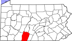 | |
| Townships | ||
| CDPs | ||
| Unincorporated communities | ||