College Heights Historic District
|
College Heights Historic District | |
|
Corner of Hillcrest Ave. and Woodland Dr. in 2013 | |
  | |
| Location | Roughly bounded by Holmes St., Park Ave., Ridge Ave., Sunset Rd., Hillcrest Ave., Woodland Dr. and Mitchell Ave., State College, Pennsylvania |
|---|---|
| Coordinates | 40°47′57″N 77°52′28″W / 40.79917°N 77.87444°WCoordinates: 40°47′57″N 77°52′28″W / 40.79917°N 77.87444°W |
| Area | 109 acres (44 ha) |
| Built | 1904 |
| Architectural style | Colonial Revival, Tudor Revival, Bungalow/craftsman |
| NRHP Reference # | 95000514[1] |
| Added to NRHP | April 27, 1995 |
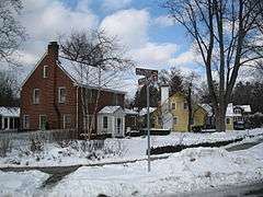
College Heights Historic District is a national historic district located at State College, Centre County, Pennsylvania. The district includes 278 contributing buildings in an almost exclusively middle-class residential area of State College. The district reflects the growth and architecture of State College as an emerging college town. The houses are largely wood frame and reflect a number of popular early-20th-century architectural styles including Colonial Revival, Tudor Revival, and Bungalow.[2]
It was added to the National Register of Historic Places in 1995.[1]
References
- 1 2 National Park Service (2010-07-09). "National Register Information System". National Register of Historic Places. National Park Service.
- ↑ "National Historic Landmarks & National Register of Historic Places in Pennsylvania" (Searchable database). CRGIS: Cultural Resources Geographic Information System. Note: This includes Jacqueline Melander and Deryck Holdsworth (February 1995). "National Register of Historic Places Inventory Nomination Form: College Heights Historic District" (PDF). Retrieved 2011-11-05.
| Topics |   | |
|---|---|---|
| Lists by county |
| |
| Lists by city | ||
| Other lists | ||
| ||
This article is issued from Wikipedia - version of the 11/28/2016. The text is available under the Creative Commons Attribution/Share Alike but additional terms may apply for the media files.