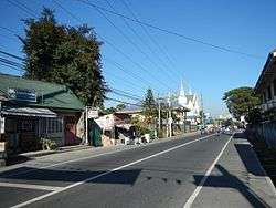
Concepcion, Tarlac
| Concepcion | ||
|---|---|---|
| Municipality | ||
 | ||
| ||
| Motto: My home,My place,My town,My CONCEPCION! | ||
.svg.png) Concepcion Location within the Philippines | ||
| Coordinates: 15°19′N 120°39′E / 15.317°N 120.650°ECoordinates: 15°19′N 120°39′E / 15.317°N 120.650°E | ||
| Country | Philippines | |
| Region | Central Luzon (Region III) | |
| Province | Tarlac | |
| District | 3rd District | |
| Founded | 1863 | |
| Barangays | 45 | |
| Government[1] | ||
| • Mayor | Andres D. Lacson (NPC) | |
| Area[2] | ||
| • Total | 242.99 km2 (93.82 sq mi) | |
| Population (2015)[3] | ||
| • Total | 154,188 | |
| • Density | 630/km2 (1,600/sq mi) | |
| Time zone | PST (UTC+8) | |
| ZIP code | 2316 | |
| Dialing code | 45 | |
| Income class | 1st class,Highly Urbanized | |

Concepcion is a first class highly urbanized municipality in the province of Tarlac, Philippines. According to the 2015 census, it has a population of 154,188.[3]
Geography
Concepcion is one of the largest municipalities of the province of Tarlac. It is 7.5 kilometers from the Capas junction along McArthur Highway. It lies on the south-eastern tip of Tarlac, bordered in the south by Magalang, Pampanga, in the east by San Antonio, Nueva Ecija, in the north-east by La Paz, in the north-west by Tarlac City, in the west by Capas, and in the south-west by Bamban. It covers an area of 245.7 km².
It has two great rivers, the first being Lucong river which originates from Dingding and Namria creeks in Capas, Tarlac, is visible from the bridge at Barangay Santiago, it merges with the Rio Chico before joining the Pampanga River. The second is Parua river which originates from Sacobia-Bamban river that comes from Mount Pinatubo. Parua River is heavily silted with 7 meters of sand deposits, its bridge was destroyed by lahar and is visible at Barangay San Nicolas Balas, it also merges with the Rio Chico before joining Pampanga River. Both rivers are utilized for irrigating agricultural lands of the town, consisting mainly of rice and sugar crops. Parua river which at times appears as a bed of sand due to the scarcity of water, is also a Quarry site for sand and Ash used as construction material etc.
Barangays
Concepcion is politically subdivided into 45 barangays.[2]
| Barangay | Population (2013) | Barangay Fiesta |
|---|---|---|
Town proper |
||
| August 29–30 | ||
History
In 1860, the towns of Concepcion and Magalang once comprised a single town named San Bartolome (presently an abandoned town and a barangay of Concepcion) which was a military "Commandancia" of Pampanga under the Spanish regime. A great inundation devastated the whole settlement of then San Bartolome in 1863 and the people were left with no other choice but to abandon the place. It was also at this point when the people were divided as to the place where they are to resettle. Some went North and others went South. The first group headed by Don Pablo Luciano, the Governadorcillo, organized its own settlement in the slope of Mt. Arayat down South and named the settlement after him. Eventually, the place was renamed Magalang. The second group who took refuge up North comprised the Santoses, Laxamanas, Salvadors, Yumuls, Castros, Dizons, Pinedas, Felicianos, Aquinos, Corteses, Bermudezes, Perezes, Punsalangs and many others, and settled to a place (now called Sto. Nino) then occupied by the Lindos and the Amuraos (Don Esquolastiquo Amurao and Don Gaston Amurao), to be their new site. Most of the settlers became dissatisfied with the place as it abounds with snakes and was scarce in water. They moved further South to a place we now know as Concepcion. The settlers began clearing the land and built huts and roads. After several years, they named their place Concepcion, after the Immaculate Concepcion, who is believed to be miraculous and to possess power over snakes that abound the place.[4]
Timeline
- 1863: A catastrophic flood devastated the whole town of San Bartolome which gave birth to the towns of Concepcion and Magalang.
- 1897: The Katipunan was organized under General Servillano Aquino.
- 1898-1900: The first Municipal President, Moises Castro, was elected under the short-lived Philippine Republic under General Emilio Aguinaldo.
- 1900: General Servillano Aquino was captured by the Americans and sentenced to hang.
- 1902: Captain Smith established the First American government in town and appointed Don Marciano Barrera as the First Filipino President.
- 1904: General Aquino was pardoned by order of the President of the United States, Theodore Roosevelt.
- 1911: The Gabaldon School building was constructed, costing about fifty thousand pesos (P 50,000.00).
- 1918: Influenza epidemic hit the town and people died by the hundreds.
- 1929: The municipal building worth fifty thousand pesos (P 50,000.00) and two bandstands worth five thousand pesos (P 5000.00) each were constructed.
- 1935: The Commonwealth government was installed with Don Gregorio Palma as the Municipal President.
- 1939: The town plaza, costing twenty thousand pesos (P 20,000.00), was fenced and named Don Benigno Q. Aquino Sr. Memorial Park.
- 1942: The Japanese occupation of the town began, a period of brutalities and killings.
- 1942: The built of the military garrisons of the Imperial Japanese Army was station's active in the town.
- 1942-1944: Recognized guerrillas and HUKBALAHAP communist fighters were aiding local troops of the Philippine Commonwealth Army units crashed the siege the conflict battles against the Japanese around the town until almost three years of siege are withdrew and retreating guerrillas and HUKBALAHAP fighters from the Japanese hands.
- December 27, 1944: Japanese occupation forces left the town. HUKBALAHAP took over until January 1945.
- January–August 1945: Filipino and American ground troops including recognized guerrillas and HUKBALAHAP communist groups liberated the town and defeating Imperial Japanese troops and World War II ends.
- 1945-1946: The built of the general headquarters of the Philippine Commonwealth Army and Philippine Constabulary was military active and station in the town was military operates around liberated in Central Luzon are aiding recognized guerrillas, the HUKBALAHAP communist fighters and the U.S. liberation forces was fought against the Japanese until the Post-World War II era.
- 1945: The Commonwealth government was reestablished in the town.
- 1946: On Independence Day, General Servillano Aquino and Reymundo Panlilio hoisted the Philippine flag in a simple but solemn ceremony at the Benigno Aquino Memorial Park.
- 1948: Benigno Aquino Memorial High School was established.
- 1950: Citizen's Army was organized to fight all forms of communism.
- 1951: The town won as the cleanest and the most beautiful town in the Provincial Clean-up Week.
- 1952: A municipal library was established.
- 1955: The political career of Ninoy Aquino began when he won as the youngest mayor of Concepcion by the age of 22.
- 1962: Concepcion was divided into two school districts.
- 1963: Concepcion was divided into three school districts.
- 1971: Concepcion was divided into four school districts.
- 1972: Forty days of continuous rain put the town under water. Concepcion Emergency Hospital was established.
- September 21, 1972: President Marcos declares Martial Law.
- 1974: Lucong Bridge was reconstructed under the US-RP Aid, and the barangay market was constructed.
- 1975: The Concepcion Public Library building was constructed.
- June 1977: Concepcion Jaycees, Inc. was organized.
- June 17, 1978: Concepcion Educational Foundation (CEFI) was organized.
- April 7, 1979: Rotary Club of Southern Tarlac (RCST) was organized.
- October 8, 1979: Land Bank of the Philippines, Concepcion Field Office was established.
- August, 1980: Concepcion Water District was established.
- September 25, 1980: Concepcion Water District took over the reins of MWSS.
- April 28, 1981: District Electrification Committee was organized preparatory to the organization of the Electric Cooperative.
- June 8, 1981: Tarlac II Electric Cooperative was established covering the municipalities of Bamban, Capas, La Paz and Concepcion (Tarlac) and Zaragoza (Nueva Ecija), with Mr. Feliciano S. Garcia as President.
- February 28, 1982: The Assemblywoman Mercedes C. Teodore Overflow Bridge was constructed in Padpad, barangay San Jose.
- August 1, 1982: TARELCO II took over the reins of Compana Luz Electrica (CLE).
- March 14, 1983: Barangay San Nicolas Balas became the first barangay to be energized by TARELCO II.
- March 19, 1983: Inauguration of the approaches of the Parua River.
- August 21, 1983: Benigno "Ninoy" Aquino was assassinated.
- 1983: Aquino Memorial High School was reconstructed.
- 1984: The public market was reconstructed under the Economic Support Fund Secretariat.
- 1986: In the snap elections, Corazon C. Aquino, the widow of Ninoy Aquino was declared winner.
- February 22–25, 1986: The EDSA revolution took place. Corazon Aquino became the President while Alfredo Avena was declared Officer in Charge of the Office of the Mayor.
- 1986: A plebiscite for the approval of the revised Constitution of the Republic of the Philippines was held.
- 1987: A bronze statue of Ninoy Aquino was erected in front of the municipal building while Herminio S. Aquino was elected Congressman for the 3rd District of Tarlac.
- 1987-88: Concreting of the Concepcion - Magalang road.
- 1988: Danilo D. David was elected Mayor of Concepcion.
- May 1989: Barangay election took place.
- July 1989: Budget Secretary Guillermo Carague turned over a check worth P14 million (fourteen million pesos) to the municipal government through Mayor Danilo D. David to purchase heavy equipment. (Purchase was later made by the municipal government).
- July 16, 1990: A killer earthquake devastated barangays Sto Nino, Sta. Cruz, Corazon de Jesus, Pitabunan Talimundoc, San Miguel, and partly destroyed the Immaculate Concepcion Church.
- June 12, 1991: Mount Pinatubo erupted bringing about far reaching adverse consequences to the whole town.
- July 22, 1991: Lahar (flowing mud and volcanic debris) destroys Parua river dikes, wreaks havoc on nearby barangays, and totally destroys barangays San Martin, Malupa and the southern portion of Sta. Rita.
- 1992: Evacuees were resettled in Camp O'Donnell.
- March 13, 1993: Kabalikat Civicom Concepcion-Tarlac Chapter was organized and founded by several amateur radio modulators.
- May, 1992: Alfredo P. Avena was elected mayor.
- December, 1993: The construction of the Concepcion Training Center began.
- January 27, 1994: Aquino Memorial High School was renamed Benigno S. Aquino National High School by virtue of House Bill no. 4952 authored by Rep. Herminio S. Aquino. This was enacted into law on May 4, 1994 as R.A.7703.
- March 2001: Benjamin Lacson was elected mayor.
- 2004: The Concepcion Legislatve Building was constructed where the new municipal library is in the first floor and the office of the Vice Mayor is in the third floor of the building.
- May 2004: Noel L. Villanueva was elected mayor.
- 2005: The bridge of Parua River was constructed to connect Brgy. Sta Rita to the other barrio's in the south like San Antonio, Balutu, San Bartolome etc. with the inauguration ceremony headed by President Gloria Macapagal Arroyo.
- 2005-2007: The Immaculate Conception Parish Church was renovated.
- March 2006: For the first time in the history of Concepcion, only one candidate run for the office of the mayor spot which is Noel L. Villanueva only so he automatically wins.
- 2007: The Municipal Building was renovated.
- October, 2008: The back part of the municipal Public Market was renovated as a project of President Gloria Macapagal Arroyo.
- November, 2008: The Municipality of Concepcion joined the Belenismo ng Tarlac as one of their official candidate in the Belen Making Contest held in Tarlac City every December to January.
- December, 2008: As the people of Concepcion celebrates the Christmas Season and the feast day of their patron saint Immaculate Conception. They are also gathered for their Municipal's 145th Foundation Day, on Dec. 14 (Sunday), a week of celebration every night started Dec. 8-14.
- December, 2009: Anastacio G. Yumul High School(AGHYS)was stablish.
- May, 2010: Noel L. Villanueva and Andres D. Lacson were elected as Mayor and Vice-Mayor, respectively.
- August 7, 2010: Caluluan High School (CHS) held its first grand alumni homecoming in celebration of its 44 years founding anniversary. The event was spearheaded by the School Principal, Mr. Mario M. Tayag together with the school faculty. Highlight of the event is the founding of CHS Alumni Association and election of officers.
- June, 2013: Andres "Andy" D. Lacson was elected mayor
Demographics
| Population census of Concepcion | ||
|---|---|---|
| Year | Pop. | ±% p.a. |
| 1990 | 103,146 | — |
| 1995 | 101,243 | −0.35% |
| 2000 | 115,171 | +2.80% |
| 2007 | 135,213 | +2.24% |
| 2010 | 139,832 | +1.23% |
| 2015 | 154,188 | +1.88% |
| Source: National Statistics Office[3][5] | ||
Points of interest
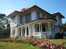
- 72-year-old Aquino Family Ancestral House-Concepcion Tarlac Family Ancestral House-Concepcion Tarlac - The marker was unveiled by President Aquino, Jr. on September 10, 2011. (Ancestral houses of the Philippines).
- Santuario de la Immaculada Concepción (Formerly Immaculate Conception Parish Church) belongs to the Roman Catholic Diocese of Tarlac (Latin: Dioecesis Tarlacensis) under the current bishop, Florentino Ferrer Cinense, appointed in 1988. and under the Vicariate of the Immaculate Conception, Vicar Forane: Msgr. Tirso Daquigan, Parish Priest, Titular: Immaculate Conception, Feast day, December 8). Fr. Melvin P. Castro, Chancellor.
- Col. Jesus R. Lapus Memorial Sports Complex
- The Subic-Clark-Tarlac Expressway (SCTEX)
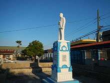
- Ninoy Aquino Monument (Bronze Statue)
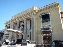
- Concepcion Municipal Hall (printed at the back of 500 peso bill)
- Orchard Valley Resort
- Voice of America Relay Station
Notable people from Concepcion
- Ninoy Aquino - was a youngest Municipal Mayor of Concepcion 1955-1959 and then he became the youngest governor of the tarlac province and become a Philippine senator and a leading opposition leader to the autocratic rule of Ferdinand Marcos. He was assassinated at the Manila International Airport (now named the Ninoy Aquino International Airport in his honor) upon returning home from exile in the United States. His death catapulted his widow, Corazon Aquino, to the limelight and the presidency, subsequently replacing the 20-year-old Marcos regime (from Brgy. San Jose Pob.).
- Benigno Aquino, Sr.- was a Philippine senator and served as Speaker of the Second Philippine Republic National Assembly from 1943 to 1944. he is the father of Ninoy Aquino. (from Brgy. Murcia)
- Eva Estrada-Kalaw- is a Philippine senator and served as a congresswoman in the Congress of the Philippines for 7 years. (1965–1972). Serving in Congress during the presidency of Ferdinand Marcos (Nationalist), she was part of a major transformation in Philippine domestic and foreign policies. (from Brgy. Murcia)
- Jesli Aquino Lapus - is a former Congressman of 3rd District of Tarlac and now Secretary of Department of Trade and Industry as of 2010. He had also served as Secretary of Education from 2006 to 2010. (from Brgy. San Nicolas Pob.)
- Lorna Tolentino - is a multi-awarded actress and TV host. (from Brgy. Minane)
- Tyron Perez - is a teen star and avenger in GMA's reality artista search, StarStruck. (from Brgy. Alfonso)
- CJ Suarez - is a 2003 World Cup Bowling Champion.
- Karen Punzalan - actress, gravure model
Public high schools
Anastacio G. Yumul High School (formerly:Balutu National High School) (Brgy. Balutu)
Benigno S. Aquino National High School (San Nicholas Poblacion)
Caluluan National High School (main) (Brgy Caluluan)
Caluluan National High School (annex)
Sta.Rosa Integrated School (Brgy. Sta. Rosa)
| Wikimedia Commons has media related to Concepcion, Tarlac. |
- Philippine Standard Geographic Code
- Philippine Census Information
- Local Governance Performance Management System
- Ancestral house of Aquinos
- 3 Generations lived in the house
- Aquino House marker unveiling
- Unveiling of the Marker
 |
Tarlac City, La Paz | | ||
| Capas Bamban |
|
San Antonio, Nueva Ecija | ||
| ||||
| | ||||
| Mabalacat, Pampanga | Magalang, Pampanga | Cabiao, Nueva Ecija |
Tarlac City (capital) | |
| Municipalities | |
| Component city | |
| Barangays | |
References
- ↑ "Municipalities". Quezon City, Philippines: Department of the Interior and Local Government. Archived from the original on 25 January 2013. Retrieved 28 November 2012.
- 1 2 "Province: Tarlac". PSGC Interactive. Makati City, Philippines: National Statistical Coordination Board. Archived from the original on 14 November 2012. Retrieved 28 November 2012.
- 1 2 3 "Total Population by Province, City, Municipality and Barangay: as of May 1, 2015". 2015 Census of Population and Housing. Philippine Statistics Authority. Retrieved 24 May 2016.
- ↑ http://www.concepciontarlac.com/html/history.htm
- ↑ "Province of Tarlac". Municipality Population Data. LWUA Research Division. Retrieved 11 September 2013.