Concepcion Islands
|
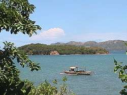
Offshore island of Concepcion, Iloilo | |
.svg.png) Concepcion Islands Location within the Philippines | |
| Geography | |
|---|---|
| Coordinates | 11°16′57″N 123°10′00″E / 11.28250°N 123.16667°ECoordinates: 11°16′57″N 123°10′00″E / 11.28250°N 123.16667°E |
| Archipelago | Visayas |
| Adjacent bodies of water | |
| Total islands | 17 |
| Major islands | |
| Area | 34.97 km2 (13.50 sq mi)[1] |
| Highest elevation | 2,900 ft (880 m) |
| Highest point | Manaphag |
| Administration | |
| Region | Western Visayas |
| Province | Iloilo |
| Municipality | Concepcion |
| Barangays |
|
| Demographics | |
| Population | 19,080 (2010)[2] |
| Additional information | |
| Official website | Concepcion official website |
The Concepcion Islands are 17 variously inhabited and uninhabited islands in northeastern Iloilo, Philippines. The islands are politically subdivided into 11 island barangays and are part of the municipality of Concepcion.[3] Collectively, the islands have a population of 19,080, which is 48 percent the total population of Concepcion.
Location and geography
The Concepcion Islands are located east of Panay Island in the Visayan Sea, and are part of the larger Western Visayas archipelago. The islands are part of the town of Concepcion, and comprise 40 percent of Concepcion's total land area.[1] The nearest island is Tago, which is a coral reef 200 metres (660 ft) from the mainland, inside Concepcion Bay. The furthest island is far-flung Baliguian, located 22 kilometres (14 mi) away from the mainland. Baliguian also marks the end of Concepcion's municipal waters. The majority of the islands are mountainous and wooded, ringed by white sand beaches and surrounded by reefs, shoals, and sandbars.[4] A few of the islands feature lighthouses to aid ship navigation in this area.
History
In 1604, Juan Salgado twice defeated Spanish pirates near Pan de Azucar.[5] During World War II, Japanese forces shot down an American fighter pilot, which crash landed near Bag-o Abo Island.[1]
Islands
The Concepcion Islands are:
- Agho Island
- Anauayan Island
- Bag-o Abo Island
- Bag-o Isi Island
- Baliguian Island
- Bocot Island
- Botlog Island
- Bulubadiangan Island
- Chico Island (Bag-o Sipol Island)
- Colebra Island (Bago-alas Island)
- Danao-Danao Island
- Igbon Island
- Malangabang Island
- Pan de Azucar Island
- Sombrero Island
- Tago Island
- Tagubanhan Island
See also
References
- 1 2 3 "Municipality of Concepcion". Province of Iloilo official webpage. Retrieved 22 June 2014.
- ↑ "2010 Census of Population and Housing" (PDF). Philippine Statistics Authority. 2010. pp. 61–62. Archived from the original (PDF) on 15 December 2012. Retrieved 22 June 2014.
- ↑ Ahem, Claire. "In Typhoon-Ravaged Concepcion, Not Afraid to Look Back but All Eyes on the Future". Concern Worldwide. Retrieved 17 June 2014.
- ↑ "Sailing Directions (Enroute) Philippine Islands" (PDF). National Geospatial-Intelligence Agency. 2008. p. 95. Retrieved 22 June 2014.
- ↑ Blair, Emma (ed.). "XXX". The Philippine Islands, 1493–1898, Volume XXIV, 1630–34 (ebook). Project Guttenberg. Retrieved 23 June 2014.