Corsica, Pennsylvania
| Corsica, Pennsylvania | |
|---|---|
| Borough | |
|
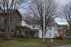
Houses on Main Street | |
 Corsica, Pennsylvania | |
| Coordinates: 41°10′52″N 79°12′08″W / 41.18111°N 79.20222°WCoordinates: 41°10′52″N 79°12′08″W / 41.18111°N 79.20222°W | |
| Country | United States |
| State | Pennsylvania |
| County | Jefferson |
| Settled | 1802 |
| Incorporated | 1860[1] |
| Government | |
| • Type | Borough Council |
| • Mayor | David Leadbetter |
| • President | Carol Cox |
| • Vice President | Alan Bowley |
| • Secretary | Tammy Laird |
| Area | |
| • Total | 0.5 sq mi (1 km2) |
| Population (2000) | |
| • Total | 354 |
| • Density | 758.9/sq mi (293.0/km2) |
| Time zone | Eastern (EST) (UTC-5) |
| • Summer (DST) | EDT (UTC-4) |
| Zip code | 15829 |
| Area code(s) | 814 |
| Website | http://www.boroughofcorsica.com |
Corsica is a borough in Jefferson County, Pennsylvania, United States. The population was 354 at the 2000 census. It was named for the Island of Corsica, birthplace of Napoleon Bonaparte. The mayor of Corsica is Dave Leadbetter.
Geography
Corsica is located at 41°10′52″N 79°12′8″W / 41.18111°N 79.20222°W (41.181233, -79.202287).[2]
According to the United States Census Bureau, the borough has a total area of 0.5 square miles (1.3 km2), all of it land.
History
Corsica suffered a devastating fire in 1873, which destroyed most of the town's businesses and residences.
The first spade of dirt signifying the groundbreaking for Interstate 80 was shoveled on March 19, 1959 near Corsica.
Demographics
| Historical population | |||
|---|---|---|---|
| Census | Pop. | %± | |
| 1860 | 249 | — | |
| 1870 | 372 | 49.4% | |
| 1880 | 391 | 5.1% | |
| 1890 | 338 | −13.6% | |
| 1900 | 293 | −13.3% | |
| 1910 | 301 | 2.7% | |
| 1920 | 358 | 18.9% | |
| 1930 | 391 | 9.2% | |
| 1940 | 481 | 23.0% | |
| 1950 | 421 | −12.5% | |
| 1960 | 431 | 2.4% | |
| 1970 | 374 | −13.2% | |
| 1980 | 381 | 1.9% | |
| 1990 | 337 | −11.5% | |
| 2000 | 354 | 5.0% | |
| 2010 | 357 | 0.8% | |
| Est. 2015 | 351 | [3] | −1.7% |
| Sources:[4][5][6] | |||
As of the census[5] of 2000, there were 354 people, 145 households, and 94 families residing in the borough. The population density was 758.9 people per square mile (290.8/km²). There were 157 housing units at an average density of 336.6 per square mile (129.0/km²). The racial makeup of the borough was 98.59% White, 0.85% Asian, and 0.56% from two or more races.
There were 145 households, out of which 30.3% had children under the age of 18 living with them, 55.2% were married couples living together, 4.8% had a female householder with no husband present, and 34.5% were non-families. 30.3% of all households were made up of individuals, and 11.7% had someone living alone who was 65 years of age or older. The average household size was 2.44 and the average family size was 3.08.
In the borough the population was spread out, with 26.6% under the age of 18, 11.0% from 18 to 24, 28.0% from 25 to 44, 20.3% from 45 to 64, and 14.1% who were 65 years of age or older. The median age was 34 years. For every 100 females there were 114.5 males. For every 100 females age 18 and over, there were 101.6 males.
The median income for a household in the borough was $30,625, and the median income for a family was $38,438. Males had a median income of $27,813 versus $18,125 for females. The per capita income for the borough was $13,752. About 7.1% of families and 11.0% of the population were below the poverty line, including 8.2% of those under age 18 and 17.8% of those age 65 or over.
Public services
The Clarion-Limestone Area School District provides Kindergarten through 12th grade public education for the community. Clarion-Limestone Area School District operates two schools; Clarion-Limestone Jr/Sr High School (7th-12th) and Clarion-Limestone Elementary School (K-6th).
Corsica Borough is home to the Corsica Volunteer Fire Department.
References
- ↑ McKnight, William James (1917). Historical. J.H. Beers. p. 498.
- ↑ "US Gazetteer files: 2010, 2000, and 1990". United States Census Bureau. 2011-02-12. Retrieved 2011-04-23.
- ↑ "Annual Estimates of the Resident Population for Incorporated Places: April 1, 2010 to July 1, 2015". Retrieved July 2, 2016.
- ↑ "Census of Population and Housing". U.S. Census Bureau. Archived from the original on 11 May 2015. Retrieved 11 December 2013.
- 1 2 "American FactFinder". United States Census Bureau. Archived from the original on 2013-09-11. Retrieved 2008-01-31.
- ↑ "Incorporated Places and Minor Civil Divisions Datasets: Subcounty Resident Population Estimates: April 1, 2010 to July 1, 2012". Population Estimates. U.S. Census Bureau. Archived from the original on 17 June 2013. Retrieved 11 December 2013.
Municipalities and communities of Jefferson County, Pennsylvania, United States | ||
|---|---|---|
| Boroughs | 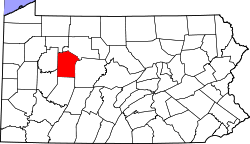 | |
| Townships | ||
| CDP | ||
| Unincorporated communities |
| |
| Footnotes | ‡This populated place also has portions in an adjacent county or counties | |