Cranberry Lake, New York
| Cranberry Lake | |
|---|---|
| hamlet & CDP | |
|
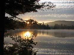
Black Duck Hole, Cranberry Lake | |
 Cranberry Lake Location within the state of New York | |
| Coordinates: 44°13′21″N 074°50′11″W / 44.22250°N 74.83639°WCoordinates: 44°13′21″N 074°50′11″W / 44.22250°N 74.83639°W[1] | |
| Country | United States |
| State | New York |
| County | St. Lawrence County |
| Town | Town of Clifton |
| Area[2] | |
| • Total | 19.713 sq mi (51.06 km2) |
| • Land | 19.437 sq mi (50.34 km2) |
| • Water | 0.276 sq mi (0.71 km2) |
| Elevation[1] | 1,489 ft (454 m) |
| Population (2010)[3] | |
| • Total | 200 |
| • Density | 10.1/sq mi (3.9/km2) |
| Time zone | Eastern (EST) (UTC-5) |
| • Summer (DST) | EDT (UTC-4) |
| ZIP code[4] | 12927 |
| Area code | 315 |
| FIPS code[2][5] | 36-18817 |
| GNIS feature ID[5] | 976196 |
Cranberry Lake is a hamlet in the eastern part of the Town of Clifton, in St. Lawrence County, New York, United States. It lies along New York State Route 3 on the north shore of Cranberry Lake. The population was 200 at the 2010 census, which lists the community as a census-designated place.[3]
Cranberry Lake, despite being one of the largest lakes in the Adirondacks, has mostly been preserved, because most of the land is owned by the state of New York. Cranberry Lake also has plenty of ponds and mountains which have trails for extensive hiking. For experienced hikers can travel through the Cranberry Lake 50, and 50 mile hike around the Lake.
Geography
Cranberry Lake is located at 44°13′21″N 074°50′11″W / 44.22250°N 74.83639°W (44.2225615, -74.8362986) and its elevation is 1,489 feet (454 m).[1]
According to the 2010 United States Census, the CDP has a total area of 19.713 square miles (51.06 km2), of which 19.437 square miles (50.34 km2) is land and 0.276 square miles (0.71 km2) is water.[2]
References
- 1 2 3 "Cranberry Lake". Geographic Names Information System. United States Geological Survey. Retrieved January 13, 2013.
- 1 2 3 "Places: New York". 2010 Census Gazetteer Files. United States Census Bureau. Retrieved January 13, 2013. External link in
|work=(help) - 1 2 "Profile of General Population and Housing Characteristics: 2010 Demographic Profile Data: Cranberry Lake CDP, New York". United States Census Bureau. Retrieved January 13, 2013.
- ↑ "Post Offices By County: Saint Lawrence County, New York". United States Postal Service. Retrieved January 13, 2013.
- 1 2 "FIPS55 Data: New York". FIPS55 Data. United States Geological Survey. February 23, 2006. Archived from the original on October 19, 2006. External link in
|work=(help)
External links
- DEC information about Cranberry Lake recreation facilities
- Cranberry Lake Biological Station
- Google books: Smeby, Susan Thomas, Cranberry Lake and Wanakena
- The Cranberry Lake 50 hiking trail information
Municipalities and communities of St. Lawrence County, New York, United States | ||
|---|---|---|
| City |  | |
| Towns | ||
| Villages | ||
| CDPs |
| |
| Hamlets | ||