Crown Heights, Brooklyn
Coordinates: 40°39′47″N 73°56′41″W / 40.66306°N 73.94472°W


Crown Heights is a neighborhood in the central portion of the New York City borough of Brooklyn. The main thoroughfare through this neighborhood is Eastern Parkway, a tree-lined boulevard designed by Frederick Law Olmsted extending 2 miles (3.2 kilometres) east–west. Originally, the area was known as Crow Hill. It was a succession of hills running east and west from Utica Avenue to Washington Avenue, and south to Empire Boulevard and East New York Avenue.[1] The name was changed when Crown Street was cut through in 1916.[2]
Crown Heights is bounded by Washington Avenue to the west, Atlantic Avenue to the north, Ralph Avenue to the east, and Empire Boulevard/East New York Avenue to the south. It is about 1 mile (1.6 km) wide and 2 miles (3.2 km) long. Neighborhoods bordering Crown Heights include Prospect Heights to the west, Flatbush and Prospect Lefferts Gardens to the south, Brownsville to the east, and Bedford-Stuyvesant to the north.
The neighborhood extends through much of Brooklyn Community Board 8[3] and 9.[4] It is under the jurisdiction of two precincts of the New York City Police Department. The 77th Precinct is part of Brooklyn North, which covers Crown Heights, Prospect Heights and Weeksville. The 71st Precinct is part of Brooklyn South and covers the southern end of Crown Heights.[5]
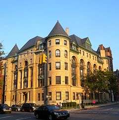
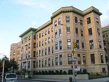
Crown Heights has extreme contrasts between ornate architecture in certain sectors and vacant, run-down buildings in other sectors. It contains a variety of people ranging from bearded, dark-suit wearing Hasidim, to vividly and brightly dressed Afro-Caribbean residents.
History
Early history
Although no known physical evidence remains in the Crown Heights vicinity, large portions of what is now called Long Island including present-day Brooklyn were occupied by the Lenape, (later renamed Delaware Indians by the European colonizers). The Lenape lived in communities of bark- or grass-covered wigwams, and in their larger settlements—typically located on high ground adjacent to fresh water, and occupied in the fall, winter, and spring—they fished, harvested shellfish, trapped animals, gathered wild fruits and vegetables, and cultivated corn, tobacco, beans, and other crops.
The first recorded contact between the indigenous people of the New York City region and Europeans was with the Italian explorer Giovanni da Verrazzano in 1524 in the service of France when he anchored at the approximate location where the Verrazano-Narrows Bridge touches down in Brooklyn today. There he was visited by a canoe party of Lenape. The next contact was in 1609 when the explorer Henry Hudson arrived in what is now New York Harbor aboard a Dutch East India Company ship, the Halve Maen (Half Moon) commissioned by the Dutch Republic.
European habitation in the New York City area began in earnest with the founding of a Dutch fur trading settlement, later called "Nieuw Amsterdam" (New Amsterdam), on the southern tip of Manhattan in 1614. By 1630, Dutch and English colonists started moving into the western end of Long Island. In 1637, Joris Jansen de Rapalje[6] purchased about 335 acres (1.36 km2) around Wallabout Bay and over the following two years, director Kieft of the Dutch West India Company purchased title to nearly all the land in what is now Kings County and Queens County from the indigenous inhabitants.
Finally, the areas around present-day Crown Heights saw its first European settlements starting in about 1661/1662 when several men each received, from Governor Peter Stuyvesant and the directors of the Dutch West India Company what was described as “a parcel of free (unoccupied) woodland there” on the condition that they situate their houses “within one of the other concentration, which would suit them best, but not to make a hamlet.”[7][8]
Early and mid-20th century
Crown Heights had begun as a posh residential neighborhood, a place for secondary homes in which Manhattan's growing bourgeois class could reside. The area benefited by having its rapid transit in a subway configuration, the IRT Eastern Parkway Line (2 3 4 5 trains), in contrast to many other Brooklyn neighborhoods, which had elevated lines. Conversion to a commuter town also included tearing down the 19th century Kings County Penitentiary at Carroll Street and Nostrand Avenue.[9]
Beginning in the early 1900s, many upper-class residences, including characteristic brownstone buildings, were erected along Eastern Parkway. Away from the parkway were a mixture of lower middle-class residences. This development peaked in the 1920s. Before World War II Crown Heights was among New York City's premier neighborhoods, with tree-lined streets, an array of cultural institutions and parks, and numerous fraternal, social and community organizations.
From the early 1920s through the 1960s, Crown Heights was an overwhelmingly white neighborhood and predominantly Jewish.[10] Population changes began in the 1920s with newcomers from Jamaica and the West Indies, as well as African Americans from the South. In 1950, the neighborhood was 89 percent white, with some 50 to 60 percent of the white population, or about 75,000 people, being Jewish, and a small, growing black population. By 1957, there were about 25,000 blacks in Crown Heights, making up about one-fourth of the population.[10] There were thirty-four large synagogues in the neighborhood, including the Bobov, Chovevei Torah, and 770 Eastern Parkway, home of the worldwide Lubavitch movement. There were also three prominent Yeshiva elementary schools in the neighborhood, Crown Heights Yeshiva on Crown Street, the Yeshiva of Eastern Parkway, and the Reines Talmud Torah.
Late 20th century
The 1960s and 1970s were a time of turbulent race relations in the area: With increasing poverty in the city, racial conflict plagued some of its neighborhoods, including Crown Heights, with its racially and culturally mixed populations. The neighborhood's relatively large population of Lubavitch Hasidim, at the request of their leader, the Lubavitcher Rebbe Menachem Mendel Schneersohn stayed in the community after other whites left.[11]
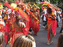
In 1964 the Labor Day Carnival celebrating Caribbean culture was moved to the neighborhood when its license to run in Harlem was revoked. It now attracts between one and three million people and is held on the first Monday in September.
During the Lyndon B. Johnson administration, Crown Heights was declared a primary poverty area due to a high unemployment rate, high juvenile and adult crime rate, poor nutrition due to lack of family income, relative absence of job skills and readiness, and a relatively high concentration of elderly residents.
Violence broke out several times in the neighborhood during the late 20th century, including during the New York City blackout of 1977: More than 75 area stores were robbed, and thieves used cars to pull up roll-down curtains in front of stores. In 1991, there was a three-day outbreak known as the Crown Heights Riot, which started between the neighborhood's West Indian/African American and Jewish communities. The riots began on August 19, 1991 after Gavin Cato, the son of two Guyanese immigrants, was struck and killed by a car in the motorcade of prominent Hasidic rabbi Menachem Mendel Schneerson. Rioting began very shortly after a Jewish volunteer ambulance left the scene after reports circulated that the ambulance refused to treat Gavin Cato's injuries while removing members of the Schneerson's motorcade instead. A visiting rabbinical student from Australia was murdered in the ensuing riots. The riot unveiled long-simmering tensions between the neighborhood's black and Jewish communities, which impacted the 1993 mayoral race and ultimately led to a successful outreach program between black and Jewish leaders that somewhat helped improve race relations in the city.[12][13] Through the 1990s, crime, racial conflict, and violence decreased in the city and urban renewal and gentrification began to take effect including in Crown Heights.
Early 21st century
In the spring of 2008 racial tension flared up in a few blocks; however, it never reached the level of tension that occurred during the Crown Heights Riot of the early 1990s.[14]
In November 2013, a series of attacks on Jewish residents were suspected to be part of "knockout games". Media attention to knockout attacks increased following the incidents in Crown Heights.[15][16][17][18][19][20] In response to the violence, the Jewish community hosted an event for African-American teens, designed to promote greater understanding of Jews and their beliefs. The event, hosted by the Jewish Children's Museum, was coordinated by local Jewish organizations, public schools, and by the NYPD's 71st and 77th precincts.[21]
In some areas the increasing rents have caused the displacement of long-time residents.[22][23][24] It is not only that rents for each apartment increase drastically but building management firms such as BCB Realty affiliated with companies that buy up buildings in the neighborhood aim to remove these long-term residents by buying them out or pressuring them to move via "failing to adequately maintain apartments" according to a housing activist, with the aim of deregulating the rent-stabilized. Other tactics include relocating residents from their apartments claiming renovation and locking them out, as employed by another realtor in the neighborhood, ZT Realty.[25] Yet somehow, Crown Heights remains an overall ethnic and social melange where a wide variety of people from older residents to new immigrants and other groups continue to reside.
NYC.gov statistics for July 2015 revealed that the 77th precinct, which includes a significant part of Crown Heights, had experienced 5 murders to date compared to 5 murders in the same period in 2014, which significantly impacted by local volunteer police patrols, and a decline of 8.3% in the number of rapes (11, down from 12). Felonious assaults and burglaries also declined in that period (10 and 20.7%, respectively)[26]
One of the largest street fairs in New York City, the annual Labor Day Carnival on Eastern Parkway, continues to be a popular draw for the neighborhood.
Demographics
As of 2010, of the 142.839 residents in Crown Heights,[27] 74.7% were Black, 19.1% were White, 4.2% were Hispanic, and 2% were Asian and other ethnic groups. Crown Heights has a majority of West Indian and African American population, however there are a significant number of Hasidic Jews.[28]
Reflecting the most varied population of Caribbean immigrants outside the West Indies, Crown Heights is known for its annual West Indian Carnival. The boisterous and colorful event is the West Indian Carnival Parade, also known as "The Labor Day Parade." The vivid ostentation goes along Eastern Parkway, from Utica Avenue to Grand Army Plaza. According to the West Indian-American Day Carnival Association,[29] over 3.5 million people participate in the colorful parade each year.
It is also the location of the Worldwide Headquarters of the Chabad-Lubavitch Hasidic Jewish movement, at 770 Eastern Parkway. An Orthodox Jewish community that dates back to the 1940s has continued to thrive around that location.
Political representation
In city government, Crown Heights is part of New York City Council Districts 35[30] and 36.[31]
Crown Heights is represented in State government as part of the State Senate 19th District[32] and the State Senate 20th District.[33] In the New York State Assembly, Crown Heights is part of State Assembly District 43[34] and State Assembly District 57.[35] Crown Heights is within the boundaries of New York's 9th congressional district for the U.S. House of Representatives, represented by Democrat Yvette Clarke.
Education

Among the public schools are the International Arts Business School, The League School, The School for Human Rights, The School for Democracy and Leadership and the High School for Public Service: Heroes of Tomorrow, all on the campus of the now-closed George W. Wingate High School, and Success Academy Crown Heights, part of Success Academy Charter Schools. M.S. 587, New Heights Middle School, Achievement First Crown Heights Elementary School, and Achievement First Crown Heights Middle School are all located in Crown Heights, housed in the Mahalia Jackson School building. Explore Empower Charter School[36] is also located in Crown Heights.
Medgar Evers College is an institution of higher education in the neighborhood.
The orthodox Jewish community is serviced by gender-classified schools. Among the girls schools are Beth Rivkah Academy, the oldest girls school founded by Yosef Yitzchak Schneerson in 1943, which now hosts preschool through higher learning institutions. Newer schools include Bnos Menachem, Bais Chaya Mushka and Bnos Chomesh. The boys are educated at Oholei Torah, Yeshiva Tomchei Temimim Lubavitch, Cheder Ohr Menachem and various other smaller schools. There is also a montessori style school called Lamplighters, servicing both boys and girls in separate classrooms from age two through thirteen. Darchei Menachem is a school for boys with challenging behaviors and/or intellectual challenges.
Transportation
Crown Heights is served by the IRT Eastern Parkway Line and the IRT Nostrand Avenue Line, with major subway stations at Franklin, Nostrand, Kingston, and Utica Avenues on Eastern Parkway (2 3 4 5 trains), as well as along Nostrand Avenue at President and Sterling Streets (2 5 trains).[37] Just east of the Utica Avenue station, on the border with Brownsville, there is a park called Lincoln Terrace (also known as Arthur S. Somers Park), which slopes gently down toward the southern Brooklyn coastline; the IRT New Lots Line transitions from a tunnel to an elevated structure within this park.[38]
Several bus lines serve the area, including the B12, B14, B15, B17, B43, B44, B45, B46, B47, B48 and B65.[39]
Recreation
Crown Heights has one botanical garden:
There are also three museums in Crown Heights:
Landmarks
- Brooklyn Public Library (Eastern Parkway Branch)
- Crown Heights North Historic District
- Ebbets Field Apartments
- George W. Wingate High School
- 770 Eastern Parkway (central headquarters of the Chabad-Lubavitch Hasidic movement)
- Kol Israel Synagogue
- Medgar Evers College
- former Nassau Brewing Company
- St. Bartholomew's Protestant Episcopal Church and Rectory
- Twenty third Regiment Armory
- Weeksville Heritage Center
Notable people
- Bob Arum (born 1931), founder and CEO of Top Rank, a professional boxing promotion company
- Buckshot (born 1974), rapper
- Shirley Chisholm (1924-2005), educator and politician[40]
- Iris Cantor (born 1931), philanthropist
- Clive Davis (born 1932), music industry executive[41]
- I.A.L. Diamond (1920–88), comedy writer
- Dinah Abrahamson (1954-2013), author
- Dyme-A-Duzin (born 1992), rapper
- Joseph Esposito (born 1950), city Office of Emergency Management commissioner, started as a beat cop in Crown Heights[42]
- Eliyahu Federman, advocate for equal voting rights, sexual abuse awareness and better police-community relations in Crown Heights.
- Avraham Fried (born 1959), Hasidic singer
- Yitzchak Ginsburg (born 1944), American-born Israeli rabbi
- Allen Grubman, entertainment lawyer
- Maggie Haberman, journalist[43]
- Jamie Hector (born 1975), actor, portrays Marlo Stanfield on the HBO series The Wire
- Regina Herzlinger, professor at Harvard Business School[44]
- Gavriel Holtzberg (1979–2008), murdered Orthodox rabbi and Chabad emissary to Mumbai, India
- Simon Jacobson (born 1956), rabbi, author, journalist
- Yosef Jacobson (born 1972), rabbi, orator
- Harold S. Koplewicz (born 1953), child and adolescent psychiatrist
- Carol Laderman (1932–2010), medical anthropologist
- Nas (born 1973), famous hip-hop artist, songwriter, record producer, actor
- Norman Mailer (1923–2007), novelist, journalist, author
- Marty Markowitz (born 1945), former Brooklyn borough president[45]
- Matisyahu Miller (born 1979), reggae artist
- Stephanie Mills (born 1957), singer[46]
- Mark Naison (born 1946), professor of history and former political activist
- Lemrick Nelson (born 1975), convicted of violating Yankel Rosenbaum's civil rights in his murder during the 1991 Crown Heights riot
- Mendy Pellin, Hasidic comic
- Noel Pointer (1954–94), jazz violinist
- Aaron Raskin, religious leader, Chabad Lubavitch rabbi, and author
- Kendall Schmidt (born 1990), television actor (Big Time Rush) and singer
- Menachem Mendel Schneerson (1902–94), the Rebbe of Chabad-Lubavitch
- Meyer Seewald (born 1988) community activist, founder of the Jewish Community Watch, an organization whose mission is the prevention of child sex abuses in the Orthodox community
- Carl Sigman (1909–2000), songwriter
- Beverly Sills (1929–2007), opera singer and administrator
- Mighty Sparrow (born 1935), Calypso musician from Trinidad/West Indies
- Susan McKinney Steward (1847–1918), first African American woman to earn medical degree in New York
- Aaron Swartz (1986–2013), computer programmer, writer, archivist, political organizer, and internet activist
- William L. Taylor (1931–2010), attorney and civil rights advocate[47]
- Simcha Weinstein (born 1975), author and rabbi
- Mendy Werdyger (born 1959), Hasidic Jewish singer, songwriter, and record store owner
In film
- Project 2x1, a 2013 documentary shot with Google Glass, features the Caribbean and Hasidic residents of Crown Heights. The footage includes local scenes shot by the residents themselves.[48][49]
- A 2004 film titled Crown Heights depicts an orthodox Rabbi and a community activist helping two local youths, one Hasidic, the other African-American, form a hip-hop group. Set in the aftermath of the Crown Heights riot, the group aims at healing tensions in the neighborhood.[50]
- Wonderstruck
See also
-
 Media related to Crown Heights, Brooklyn at Wikimedia Commons
 - Brooklyn Babylon
References
Notes
- ↑ "The Eastern District of Brooklyn" by Eugene Armbruster 1912 updated 1941.
- ↑ "Crown Heights" from the 1939 "WPA Guide to New York City"
- ↑ "Community Board 8" (Official Website).
- ↑ "Community Board 9" (Official Website).
- ↑ "Brooklyn, New York Police Precincts & Patrol Districts" (includes precinct maps)
- ↑ "Notes for: Jan Joris Jansen (Rapalje) De_Rapalie" from the Janssen Verheul families in Canada and Holland database
- ↑ "Crown Heights North Historic District: Designation Report" prepared by the New York City Landmarks Preservation Commission April 24, 2007 (pdf)
- ↑ "Chapter 3.1: Woodland to City Neighborhood: 300 Years of Change" by Jerome Krase, Brooklyn College Sociology Department "Self and Community in the City", University Press of America 1982
- ↑ Brooklyn Museum open collection Crow Hill Penitentiary gate
- 1 2 Race And Religion Among the Chosen Peoples of Crown Heights By Henry Goldschmidt.
- ↑ "770 Live". 770 Live. March 20, 1940. Retrieved January 13, 2013.
- ↑ Edward S. Shapiro, "Interpretations of the Crown Heights riot." American Jewish History (2002) 90#2 pp: 97-122.
- ↑ Edward S. Shapiro, Crown Heights: Blacks, Jews, and the 1991 Brooklyn Riot (U. Press of New England, 2006)
- ↑ "Racial tensions brewing in Crown Heights." CNN.
- ↑ "Jewish Man Assaulted as Part of Sick 'Knockout' Game". CrownHeights.info. November 10, 2013.
- ↑ "Police Added in Brooklyn Neighborhood Amid "Knockout Game" Attacks". WNBC. November 20, 2013. Retrieved November 23, 2013.
- ↑ Jonathan Mark (November 20, 2013). "Mark, Jonothan. 'Knockout' Attacks A Concern. ''The Jewish Week.'' Nov. 10, 2013". Thejewishweek.com. Retrieved November 26, 2013.
- ↑ ""Brooklyn Jewish leaders offer 1500 reward for knockout game arrests". ''DNA.info''. Nov. 25, 2013". Dnainfo.com. November 22, 2013. Retrieved November 26, 2013.
- ↑ "NYPD investigating Crown Heights 'knockout' attacks on Jews as possible hate crimes – Daily News". Nydailynews.com. Retrieved November 26, 2013.
- ↑ "Yanover, Yoni. "Crown Heights Knockout-the-Jew attacks serial hate crimes". ''The Jewish Press''. Nov. 14, 2013". Jewishpress.com. Retrieved November 26, 2013.
- ↑ COLlive reporter. "A Jewish Response to Knockout." COLlive.com. January 29, 2014. Accessed February 2, 2014.
- ↑ New York Community Media Alliance, May 9, 2007: "Desperately seeking an apartment: Haitians continue to double up as rents soar". (Accessed on December 6, 2009)
- ↑ New York Times – City Room, November 16, 2007: Chan, Sewell (November 16, 2007). "Landlord Eviction Trick Backfired, Investigators Say". The New York Times. Retrieved April 30, 2010. (Accessed on December 6, 2009)
- ↑ INPRINT, August 10, 2004: "The Uncertain Fate of an Old Brooklyn Nook". (Accessed on December 6, 2009)
- ↑ Marsh, Ian, "Pressured to Move, Low-Income Tenants Resist Buyouts," Brooklyn Bureau (bkbureau.org), May 27, 2014
- ↑ "Compstat" (PDF).
- ↑ "Archived copy" (PDF). Archived from the original (PDF) on October 17, 2013. Retrieved 2013-12-09.
- ↑ Rule, Sheila (April 15, 1994). "The Voices and Faces of Crown Heights". The New York Times. Retrieved November 26, 2007.
- ↑ "West Indian-American Day Carnival Association".
- ↑ "Council Member- District: 35". Archived from the original on April 22, 2007.
- ↑ "Council Member- District: 36". Archived from the original on May 1, 2007.
- ↑ "19th Senate District" (official page).
- ↑ "20th Senate District" (official page).
- ↑ "State Assembly District 43" (official page).
- ↑ "State Assembly District 573" (official page).
- ↑ "Empower Charter School"
- ↑ "Subway Map" (PDF). Metropolitan Transportation Authority. November 2016. Retrieved 2016-11-07.
- ↑ "Lincoln Terrace / Arthur S. Somers Park : NYC Parks". New York City Department of Parks & Recreation. Retrieved 2016-10-03.
- ↑ "Brooklyn Bus Map" (PDF). Metropolitan Transportation Authority. 2016. Retrieved October 3, 2016.
- ↑ http://www.nyc.gov/html/lpc/downloads/pdf/sig/CHNIII_blurb.pdf
- ↑ Duffy, Thom. "'Celebrate Brooklyn' Readies Summer Lineup", Billboard (magazine), May 7, 2004. Accessed October 27, 2007. "My life totally revolved around Brooklyn, says Davis, recalling his boyhood in a working-class Jewish neighborhood of Crown Heights, watching the Brooklyn Dodgers play at Ebbet's Field and listening to Martin Block's Make Believe Ballroom on WNEW."
- ↑ "Mayor names ex-NYPD chief head of Office of Emergency Management". Retrieved October 3, 2016.
- ↑ Haberman, Maggie (19 April 2016). "Our Woman in New York: Primary Day, at Last". The New York Times. The New York Times. Retrieved 19 April 2016.
- ↑ Murphy, Anne. "The Accountant Is In". Retrieved October 3, 2016.
- ↑ Mead, Rebecca. "Mr. Brooklyn; Marty Markowitz-the man, the plan, the arena.", The New Yorker, April 25, 2005. Accessed August 3, 2016. "Markowitz was one of those Brooklyn children who rarely went to Manhattan: he grew up in Crown Heights, where his father worked as a waiter in a kosher delicatessen; his main entertainment was hanging out on the streets with other kids. His father died when he was nine, and several years later Markowitz's widowed mother moved to public housing in Sheepshead Bay with Marty and his two younger sisters."
- ↑ Telpha, Carol. "Neighborhoods: Close-Up on Crown Heights", The Village Voice, December 12, 2002. Accessed October 18, 2007. "Actress and singer Stephanie Mills and rapper Skoob of Das EFX are Crown Heights natives."
- ↑ Martin, Douglas. "William Taylor, Vigorous Rights Defender, Dies at 78", The New York Times, June 29, 2010. Accessed June 30, 2010.
- ↑ Sharp, Sonja. Crown Heights Documentary Claims to be First Ever Shot With Google Glass. DNAInfo.com. Oct 7, 2013.
- ↑ Brooklyn Film & Arts Festival Screening: "Brooklyn Realities – Documented". Columbia.edu.
- ↑ "Movie Reviews". Retrieved 2016-10-03.
Further reading
- Race and Religion among the Chosen Peoples of Crown Heights, by Henry Goldschmidt (Rutgers University Press, 2006)
- "Strolls Upon Old Lines: Crow Hill and Some of Its Suggestions" from the Brooklyn Eagle December 9, 1888
- Klockenbrink, Myra (January 20, 1985). "If You're Thinking of Living In: Crown Heights". The New York Times. Retrieved July 14, 2014.