Crystola, Colorado
| Crystola, Colorado | |
|---|---|
| Unincorporated community | |
 Crystola | |
| Coordinates: 38°57′21″N 105°01′38″W / 38.95583°N 105.02722°WCoordinates: 38°57′21″N 105°01′38″W / 38.95583°N 105.02722°W | |
| Country |
|
| State |
|
| County |
El Paso County Teller County[1] |
| Elevation[1] | 7,979 ft (2,432 m) |
| Time zone | MST (UTC-7) |
| • Summer (DST) | MDT (UTC-6) |
| ZIP code[2] | 80863 (Woodland Park) |
| Area code(s) | 719 |
| GNIS feature ID | 0191202 |
Crystola is an unincorporated community in El Paso and Teller counties, Colorado, United States.[1] ZIP code 80863 serves Crystola, but mail must be addressed to Woodland Park.[2]
On 27 June 2012, the town came under a mandatory evacuation notice due to the Waldo Canyon Fire.[3]
Geography
Crystola is located at 38°57′21″N 105°01′38″W / 38.95583°N 105.02722°W (38.9558243,-105.0272053).[1]
References
- 1 2 3 4 "RoadsideThoughts Crystola, Colorado". RoadsideThoughts. 2015-08-04.
- 1 2 "ZIP Code Lookup". United States Postal Service. Archived from the original (JavaScript/HTML) on November 22, 2010. Retrieved October 7, 2007.
- ↑ Waldo Canyon Fire advancing toward Douglas County: Live Blog
Municipalities and communities of El Paso County, Colorado, United States | ||
|---|---|---|
| Cities | 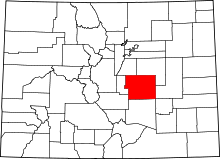 | |
| Towns | ||
| CDPs | ||
| Unincorporated communities | ||
| Footnotes | ‡This populated place also has portions in an adjacent county or counties | |
Municipalities and communities of Teller County, Colorado, United States | ||
|---|---|---|
| Cities | 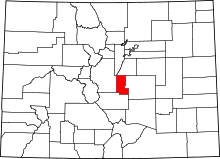 | |
| Town | ||
| CDPs | ||
| Unincorporated community | ||
| Ghost towns | ||
| Footnotes | ‡This populated place also has portions in an adjacent county or counties | |
This article is issued from Wikipedia - version of the 12/3/2016. The text is available under the Creative Commons Attribution/Share Alike but additional terms may apply for the media files.