Dante, Virginia
| Dante, Virginia | |
|---|---|
| Census-designated place | |
 Dante Location within the Commonwealth of Virginia | |
| Coordinates: 36°58′44″N 82°17′29″W / 36.97889°N 82.29139°WCoordinates: 36°58′44″N 82°17′29″W / 36.97889°N 82.29139°W | |
| Country | United States |
| State | Virginia |
| County | Russell |
| Area | |
| • Total | 7.02 sq mi (18.17 km2) |
| • Land | 7.01 sq mi (18.15 km2) |
| • Water | 0.008 sq mi (0.02 km2) |
| Elevation | 1,765 ft (538 m) |
| Population (2010) | |
| • Total | 649 |
| • Density | 93/sq mi (35.8/km2) |
| Time zone | Eastern (EST) (UTC-5) |
| • Summer (DST) | EDT (UTC-4) |
| ZIP code | 24237 |
| FIPS code | 51-21312 |
| GNIS feature ID | 2630763 |
| Website | http://danteva.org/ |
Dante is a census-designated place in Russell and Dickenson counties, Virginia, in the United States. The population as of the 2010 Census was 649.[1]
History
Dante (pronounced "Daint", rhyming with "paint") was originally called "Turkeyfoot" due to the confluence of hollows. It was originally settled in the late 1700s and early 1800s by western frontiersmen. Explosive growth occurred in the early 1900s with the discovery and exploitation of numerous bituminous coal seams. Southern industrialist George L. Carter made it the northern terminus of the Clinchfield Railroad and the headquarters of the Clinchfield Coal Company, which began to mine the nearby hollows (mainly Bear Wallow and Straight Hollow) during the early part of the 20th century. As a result, immigrants from Germany, Hungary, Greece, Poland and other central European countries flocked to the area. In 1912 Sandy Ridge, which lies immediately to the north of Dante, was punctured by the Sandy Ridge Tunnel and allowed the Clinchfield Railroad to extend all the way to Elkhorn City, Kentucky. The coal seams surrounding the town were largely exhausted by the mid 1960s and were closed in favor of new mines such as Moss #3 (A,B,C and D mines) in Duty, Virginia, which began in the late 1950s and was finally closed in the late 1970s after mining the combined Jawbone and Tiller seams to a height in excess of 30 feet (9.1 m) of clean, refinable coal. Today, Dante was mostly a decaying coal town until 2016, when a renewed interest from its residents prompted community organizations to begin discussions on a path to revitalization. CSX Transportation still operates the Dante Yard, and the Clinchfield Coal Company offices are now apartments.
Revitalization
In early 2016 the Dante Community Association was formed with citizens of Dante and representatives from Russell County. The goal of the organization is to promote the revitalization of Dante and the surrounding area by investing in infrastructure, economic development, and the community at large, they are currently in the process of applying for a planning grant.[2]
Geography
Dante is located in northwestern Russell County. The Dante CDP extends west into Dickenson County to include the settlement of West Dante. The communities are located in the valley of Lick Creek, which flows south to the Clinch River at St. Paul, and is thus part of the Tennessee River watershed. Sandy Ridge, overlooking Dante to the north, forms the Tennessee Valley divide, with waters on the opposite side flowing north via the McClure River to the Russell Fork/Levisa Fork/Big Sandy River system, reaching the Ohio River near Huntington, West Virginia.
Dante is 7.5 miles (12.1 km) north of St. Paul and 21 miles (34 km) south of Clinchco via Virginia State Route 63.
Climate
The climate in this area is characterized by hot, humid summers and generally mild to cool winters. According to the Köppen Climate Classification system, Dante has a humid subtropical climate, abbreviated "Cfa" on climate maps.[3]
References
- ↑ Virginia Trend Report 2: State and Complete Places (Sub-state 2010 Census Data). Missouri Census Data Center. Accessed 2011-06-08.
- ↑ "Dante Community Association". Dante Community Association. Retrieved 2016-11-22.
- ↑ Climate Summary for Dante, Virginia
External links
Municipalities and communities of Russell County, Virginia, United States | ||
|---|---|---|
| Towns | 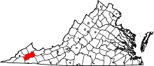 | |
| CDPs | ||
| Unincorporated community | ||
| Footnotes | ‡This populated place also has portions in an adjacent county or counties | |
Municipalities and communities of Dickenson County, Virginia, United States | ||
|---|---|---|
| Towns |  | |
| CDP | ||
| Unincorporated communities | ||
| Footnotes | ‡This populated place also has portions in an adjacent county or counties | |