Days Creek, Oregon
| Days Creek, Oregon | |
|---|---|
| Census-designated place | |
|
General store in Days Creek | |
 Days Creek  Days Creek | |
| Coordinates: 42°58′20″N 123°10′22″W / 42.97222°N 123.17278°WCoordinates: 42°58′20″N 123°10′22″W / 42.97222°N 123.17278°W | |
| Country | United States |
| State | Oregon |
| County | Douglas |
| Area | |
| • Total | 2.4 sq mi (6.1 km2) |
| • Land | 2.4 sq mi (6.1 km2) |
| • Water | 0 sq mi (0 km2) |
| Elevation | 770 ft (230 m) |
| Population (2010) | |
| • Total | 272 |
| • Density | 116/sq mi (44.6/km2) |
| Time zone | Pacific (PST) (UTC-8) |
| • Summer (DST) | PDT (UTC-7) |
| ZIP code | 97429 |
| Area code(s) | 541 |
| GNIS feature ID | 1119724[1] |
| FIPS code | 41-18150 |

Days Creek is an unincorporated community and census-designated place in Douglas County, Oregon, United States. At the 2010 census it had a population of 272.[2]
The community was named after the local creek, which in turn was named for Patrick and George Day, who settled near its mouth in 1851. The post office was established in 1878 as "Day's Creek", but the name was changed to "Days Creek" c. 1890.[3]
Geography
The community of Days Creek is located on Oregon Route 227, at the confluence of Days Creek and the South Umpqua River. It is in southern Douglas County, 7 miles (11 km) east (upriver) of Canyonville.
According to the U.S. Census Bureau, the Days Creek CDP has an area of 2.4 square miles (6.1 km2), all of it land.[2]
Climate
This region experiences warm (but not hot) and dry summers, with no average monthly temperatures above 71.6 °F (22.0 °C). According to the Köppen Climate Classification system, Days Creek has a warm-summer Mediterranean climate, abbreviated "Csb" on climate maps.[4]
References
- ↑ U.S. Geological Survey Geographic Names Information System: Days Creek, Oregon
- 1 2 "Geographic Identifiers: 2010 Demographic Profile Data (G001): Days Creek CDP, Oregon". U.S. Census Bureau, American Factfinder. Retrieved December 14, 2015.
- ↑ McArthur, Lewis A.; McArthur, Lewis L. (2003) [1928]. Oregon Geographic Names (7th ed.). Portland, Oregon: Oregon Historical Society Press. ISBN 978-0875952772.
- ↑ Climate Summary for Days Creek, Oregon
External links
Municipalities and communities of Douglas County, Oregon, United States | ||
|---|---|---|
| Cities | 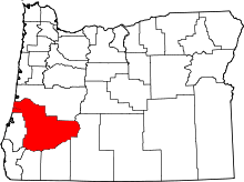 | |
| CDPs | ||
| Unincorporated communities | ||