Deerfoot Trail
| |
|---|---|
| Highway 2 | |
 | |
| Route information | |
| Maintained by Carmacks Enterprises Ltd. | |
| Length: | 46.4 km[note 1] (28.8 mi) |
| History: |
1971 (first section open) 2003 (final section completed) 2005 (freeway complete)[note 2] |
| Major junctions | |
| North end: |
|
|
Glenmore Trail Anderson Rd / Bow Bottom Trail | |
| South end: |
|
| Location | |
| Major cities: | Calgary |
| Highway system | |
| Provincial highways in Alberta | |

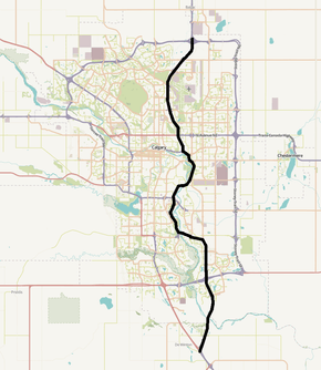
Deerfoot Trail is a major north-south freeway in Calgary, Alberta, Canada. The 46-kilometre (29 mi) segment of Highway 2 is a heavily travelled commuter route that links suburbs of Calgary to downtown via Memorial Drive, and connects Calgary to Red Deer, Edmonton, and Lethbridge. Travelling north, Highway 2 becomes Deerfoot Trail near De Winton where it splits from Macleod Trail (Highway 2A) and crosses the Bow River into city limits. It continues north across Stoney Trail before turning west to cross the Bow River again, after which it merges with the major routes of Anderson Road and Bow Bottom Trail and turns north to Glenmore Trail. It sharply turns east to cross the Bow River a third time, before curving back to the north. After interchanges with Memorial Drive and Highway 1, the freeway passes Calgary International Airport enroute to its terminus at a second interchange with Stoney Trail, from which it continues north to Red Deer and Edmonton as the Queen Elizabeth II Highway. Planners had intended to keep Deerfoot on a relatively direct path through south Calgary, but political pressure forced the freeway to the east away from existing residential areas, and later, out of Fish Creek Provincial Park.
In 1974, the route was named in honour of Deerfoot, a late 19th century Siksika Nation (Blackfoot) long distance runner known for his exceptional speed. The road was built in five segments, the first of which opened in 1971, and in 2005 it became free-flowing for its entire 46 km length after the final set of traffic lights was removed. The freeway is the busiest road in Western Canada; near downtown Calgary it is used by over 165,000 vehicles per day, almost triple the traffic for which it was designed. The first segments to be constructed segments have seen relatively few upgrades, resulting in daily traffic jams and collisions that occur at pinch points where older bridges reduce traffic to two lanes each way from the typical three.
Route description
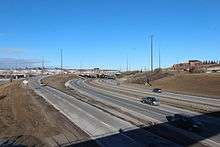
Deerfoot Trail stretches 46 km from its split with Highway 2A (Macleod Trail) near De Winton, Alberta, to Stoney Trail at Calgary's northern city limit where it becomes the Queen Elizabeth II Highway.[2][3] The Bow River flows north to south from Downtown Calgary to the southern city limit. From its south terminus, Deerfoot Trail approximates the course of the river until Memorial Drive. Initially, Deerfoot is on the east side, then crosses to the west bank, and finally back to the east before, at Inglewood, the river veers away to the west toward downtown with Memorial Drive.[4] Deerfoot is a divided freeway for its entire 46 km length, ranging from four to eight lanes wide. The northbound and southbound lanes are separated by an approximately 15 m (49 ft) wide grass median near De Winton, which narrows and becomes a combination of Jersey and constant-slope barriers through most of south Calgary before returning to grass of varying widths from 17 Avenue SE to the north terminus.[5] In north Calgary the grass median is supplemented by high-tension cable barriers to separate traffic, virtually eliminating the risk of head-on collisions.[6][7]
The freeway has a posted speed limit of 110 km/h (68 mph) from its origin at Highway 2A until just after the first Bow River crossing, after which the limit is reduced to 100 km/h (62 mph) for the next 34 km (21 mi) through most of Calgary until Beddington Trail in the northeast where the limit returns to 110 km/h.[8]
South Calgary

Deerfoot Trail begins as a rural freeway near De Winton when two lanes fork to the northeast from Macleod Trail and descend across Dunbow Road toward the Bow River.[9] It crosses the river on twin bridge structures constructed over an environmentally sensitive area of the valley.[10] Rising from the Bow, the road enters Calgary limits and its southern suburban neighbourhoods of Cranston and Seton to which access is provided by a partial cloverleaf interchange. A major junction at the Stoney Trail ring road immediately follows, with signage recommending that traffic enroute to the International Airport, Edmonton, and Medicine Hat use eastbound Stoney Trail as a bypass.[11] Continuing north as an eight lane freeway, Deerfoot bisects the communities of McKenzie Lake and McKenzie Towne across 130 Avenue SE to the south terminus of Barlow Trail. Reducing to six lanes, it curves to the west through the neighbourhoods of Douglasdale and Douglasglen across the Bow River on the Ivor Strong Bridge, named after John Ivor Strong who served as Chief Commissioner for Calgary until 1971.[12]
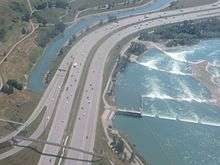
Immediately after the river, Deerfoot merges with the major routes of Anderson Road and Bow Bottom Trail, often a point of congestion at rush hour. In both directions, traffic through the outdated interchange is reduced from three lanes to two.[13] The freeway curves north along the river's west bank to cross Southland Drive, paralleling Blackfoot Trail near the community of Acadia.[4] North of Acadia, the freeway bisects a large area of commercial development for several kilometres before reaching a major interchange at Glenmore Trail.[14] This interchange is another point of congestion, the so called "Glenmore squeeze", where traffic is reduced to two lanes each way over Glenmore.[15] Deerfoot turns sharply to the east and again crosses the Bow River on the Calf Robe Bridge, named after a Sikiska elder.[16] Veering back to the north, it follows the river's east bank and crosses Peigan Trail enroute to a partial cloverleaf interchange at 17 Avenue SE, passing the neighbourhoods of Dover and Southview. Deerfoot meets Memorial Drive, a major freeway spur into downtown, near Pearce Estate Wetland, Calgary Zoo and the Max Bell Centre, and continues into north Calgary while the Bow River turns west toward downtown.[4][17]
North Calgary
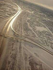
In north Calgary, the freeway climbs along the east side of Nose Creek, a tributary of the Bow River.[18] From Memorial Drive, it passes the Vista Heights neighbourhood to 16 Avenue NE (Trans-Canada Highway); this section has been largely unchanged since its completion in 1975.[17] The six lane freeway enters light commercial development north of 32 Avenue NE. Access to Huntington Hills and Deerfoot Mall are provided by an interchange at 64 Avenue NE.[18] Beddington Trail then splits to the northwest from Deerfoot, following Nose Creek into a large residential area of north Calgary that includes the neighbourhoods of Country Hills, Panorama Hills, and Hidden Valley. The speed limit on Deerfoot increases to 110 km/h as development tapers in an increasingly rural part of north Calgary. After West Nose Creek Park, an interchange with Airport Trail serves as the primary access for Calgary International Airport, and to the west, Harvest Hills via 96 Avenue NE.[19] North of Airport Trail, the freeway curves northeast through light commercial areas across Country Hills Boulevard and ends at a large interchange with Stoney Trail.[20][21] It continues north to Airdrie as the Queen Elizabeth II Highway.[3]
Traffic and collisions
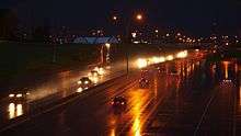
Deerfoot Trail is Alberta's busiest highway by a significant margin over Glenmore Trail, with peak daily congestion lasting as many as four hours.[22][23] Its most travelled stretch is between Memorial Drive and 16 Avenue NE (Trans-Canada Highway) as traffic from Calgary's northern and eastern suburbs converge to travel via Memorial Drive into downtown, in addition to traffic transiting the city and other intra-city trips.[23] The freeway was designed to carry approximately 65,000 vehicles per day but as of 2015 carries nearly triple that volume near Memorial Drive.[24] In late 2013, the southeastern segment of Stoney Trail was opened to traffic. In conjunction with the northeast portion which opened in 2009, it formed a full eastern bypass of Calgary providing an alternate route for traffic transiting the city.[25] Traffic levels on Deerfoot Trail decreased in the year following the opening, but have since risen to pre-Stoney levels.[26][27]
The excessive volume on Deerfoot Trail has made the freeway quite dangerous with 10,000 collisions recorded between 2002 and 2007, including 24 fatalities.[7] Constable Jeff Klatt of the Calgary Police Service stated that there is a "consensus among police officers that it’s dangerous to do traffic stops" on Deerfoot Trail.[16] A 1993 incident in which a stolen vehicle struck and killed a police officer on Deerfoot Trail was the catalyst for the Calgary Police Service's acquisition of a helicopter.[28] 2013 statistics confirmed that Deerfoot Trail had more crashes and traffic jams than any other road in Calgary.[29] Deerfoot has many entrances and exits in close proximity which exacerbates problems, but some have attributed a portion of the congestion to driver error. Constable Jim Lebedeff of the Calgary Police Service stated, "a lot of people don’t understand, or don’t want to understand, how to merge properly.”[16]
In 2015, plans for improvements to Deerfoot Trail near Southland Drive were cancelled and a study was initiated to determine the best course of action to begin improving the freeway.[15][30] The Calf Robe Bridge is also prone to collisions as its concrete deck becomes slick in cold weather, and large curves precede and follow the bridge.[16] A 1996 crash on the bridge claimed the life of a teenager when her northbound car struck the rear of a fire truck parked in the left shoulder, attending to an accident in the southbound lanes. Poor visibility due to the curve prior to the bridge was a contributing factor in a successful lawsuit by the girl's family against the city of Calgary.[31]
Alberta Transportation publishes yearly traffic volume data for provincial highways.[23] The table below compares the AADT at several locations along Deerfoot Trail using data from 2001, 2010 and 2015, expressed as an average daily vehicle count over the span of a year (AADT).
| North of | 2A Fork (De Winton) |
Stoney Tr. SE / Hwy 22X |
Anderson Road |
Glenmore Trail |
Memorial Drive |
32 Ave NE | Beddington Trail |
Country Hills Blvd | |
|---|---|---|---|---|---|---|---|---|---|
| Traffic volume (AADT) |
2001 | 18,860 | 93,830 | 104,060 | 138,960 | 110,030 | 55,970 | 49,440 | |
| 2010 | 28,280 | 62,180 | 129,690 | 120,130 | 158,050 | 140,570 | 79,820 | 62,080 | |
| 2015 | 35,300 | 84,720 | 141,930 | 127,950 | 165,530 | 153,090 | 105,170 | 78,090 | |
Interchanges
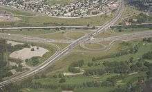
The freeway features 21 interchanges of varying design.[2] The most recent interchanges to be constructed at the north and south ends of the freeway are more consistently of the partial cloverleaf type, a design highly utilized in Alberta as it is a desirable compromise between cost and capacity. The two interchanges with Stoney Trail are cloverstack interchanges, where high capacity directional flyovers carry traffic turning left through the interchange and lesser utilized left turn movements are serviced by loop ramps.[32][33] Older and less efficient designs are used at Deerfoot's intersections with both Glenmore Trail and Highway 1. The junction with Glenmore is an incomplete cloverleaf interchange; traffic northbound on Deerfoot does not have direct access to westbound Glenmore and one must first exit to the east, proceed through a traffic light behind Calgary Auto Mall, and enter Glenmore Trail from the north side.[4] At Highway 1, a split diamond interchange significantly slows east-west traffic even outside of peak hours, because all left turn movements must pass through three sets of traffic lights.[34] This outdated interchange was Calgary's most dangerous road junction in 2011, with 234 crashes recorded.[16]
History
Background

Prior to the completion of Deerfoot Trail, the historic alignment of Highway 2 in south Calgary was along Macleod Trail as an extension of 4th Street, parallel to a branch of the Canadian Pacific Railway from Calgary to Macleod.[35][36] Macleod Trail has since been designated Highway 2A, on a routing largely the same as the original.[37] It is now a busy expressway connecting Midnapore and other southwestern suburbs to downtown. The southern most portion of the route from Highway 22X to De Winton would continue to serve as Highway 2 until completion of the Deerfoot Trail extension in 2003.
In north Calgary, Highway 2 was originally composed of four present day routes: Edmonton Trail, 41 Avenue, 48 Avenue, and Barlow Trail. Edmonton Trail is now a busy urban street on the west bank of Nose Creek through the neighbourhood of Highland Park, but its alignment in the 1920s had it curving to the northeast across the creek along present day 41 Avenue to 48 Avenue where it continued east past the airport to Barlow Trail and north to Edmonton as Highway 2.[18][38]
By the 1960s, Highway 2 had been realigned to follow Macleod Trail until turning east at Glenmore Trail (then called 68 Avenue SE) before continuing north on Blackfoot Trail, veering to the northeast, and crossing the Bow River to join Barlow Trail to the north city limit.[39] The former Edmonton Trail was re-signed as Highway 2A. 48 Avenue was reduced to an airport service road after the construction of McKnight Boulevard as the airport continued to expand.[18] Long after the opening of Deerfoot Trail and its signing as Highway 2, the segment of Barlow Trail north of McKnight Blvd was closed in 2011 to allow for expansion at Calgary International Airport.[40]
Early plans and construction
Due to its quickly rising population in the 1960s, Calgary sought construction of a new freeway and expressway network.[41] A 1967 transportation study planned for a major north-south freeway to run along the west side of the Calgary Airport across the Bow River into Inglewood, and remain west of the Bow River through present day Fish Creek Provincial Park.[42] This freeway was initially called Blackfoot Trail Freeway, the first segment of which stretched only from the northern city boundary to 16 Avenue NE and opened in 1971. It was named after an historic route that approximated the location of present day Memorial Drive across Nose Creek, between Barlow Trail and the community of St. George's Heights, now the location of the Calgary Zoo.[16][36] This trail appears on Calgary maps as early as 1891.[43]
In 1974, signs were unveiled renaming the road after a legendary Siksika Nation long distance runner known as Deerfoot.[44] In 1884 he become known in the Calgary area as an exceptional talent and would won races against runners from as far away as Europe. Controversy arose when Deerfoot won a race but his opponent was credited with the victory. Unhappy with the result, his attitude began to change; he committed theft from a cabin, and was later the subject of a massive manhunt.[45] He spent time in and out of trouble, before dying of tuberculosis while in prison for assault. He had reportedly been receiving medical treatment for the disease since his arrival to the prison.[46]
In December 1974, Premier Peter Lougheed reiterated his opposition to the planned routing for the southern portion of Deerfoot Trail, which would take the freeway along the west side of the Bow River through Fish Creek Park.[39][47] Lougheed acknowledged that diverting the freeway to the east would be significantly more expensive, but was firm on protecting and preserving Fish Creek as an urban park.[47] The revised alignment took the freeway approximately 1 km (0.62 mi) east of the river through present day Douglasdale, McKenzie Towne, and McKenzie Lake.[16] Bow Bottom Trail, a major arterial road, was built in the unnecessarily wide right of way that had been reserved for Deerfoot Trail.[48]
A second section opened extending the road further south to 17 Avenue SE opened in 1975.[16] The newly named freeway continued south, paralleling Nose Creek and was originally to continue straight across the river into Inglewood, but residents of the neighbourhood fought adamantly against construction of the freeway in their community. City Hall conceded, resulting in the present day alignment that keeps the freeway east of the Bow River as it passes downtown.[16][17]
Completion
By 1980, Deerfoot Trail had been extended further south to Glenmore Trail, and again to Highway 22X (now Stoney Trail) on its newly revised alignment by 1982. The province took over responsibility from the City of Calgary in 2000 to upgrade the road to a freeway completing the CANAMEX Corridor, after which they intended to return the road to the city.[49][50] In 2003, a $100 million extension was completed extending Deerfoot Trail from its junction with Highway 22X to its present terminus at Highway 2A near De Winton.[51] Prior to the construction of this 10 km (6.2 mi) extension, Deerfoot was effectively disconnected from the rest of Highway 2.[52] Traffic continuing south to Fort Macleod proceeded west on a two lane bridge carrying Highway 22X over the Bow River, before turning south onto Macleod Trail to join Highway 2 south of Calgary. This bridge has since been twinned, and now carries the eastbound lanes of Stoney Trail.
By 2005, interchange construction was completed at Douglasdale Boulevard, in addition to the others completed at Barlow Trail, 130 Avenue SE, McKenzie Towne Boulevard, Cranston Avenue, and Dunbow Road. In 2013, as part of the Stoney Trail SE provincial project, Deerfoot Trail was upgraded from the most southerly Bow River crossing north to McKenzie Lake Boulevard.[25] Lanes were added to both directions of travel, and the interchanges were modified to support significantly higher traffic levels. A braided ramp was constructed northbound between Cranston Avenue and Stoney Trail, preventing northbound traffic exiting to eastbound Stoney Trail from conflicting with Auburn Bay and Cranston traffic merging onto northbound Deerfoot Trail.[53][54]
Alberta Transportation has signed a contract with Carmacks Enterprises for maintenance of Deerfoot Trail from Stoney Trail in south Calgary to the northern city limit. The province intends to return control of the freeway to the city, but it is desirable for the city to avoid the significant maintenance and rehabilitation costs have the road remain under provincial control for as long as possible.[16] Former Calgary mayor Rod Sykes said, "I wouldn’t take on the problems of the Deerfoot if I were at City Hall now."[16]
Future
A study was completed by Alberta in 2007 to determine the best course of action for upgrades to the incomplete interchange of Glenmore Trail and Deerfoot Trail.[55] The interchange carries 130,000 vehicles per day on Deerfoot Trail and 100,000 vehicles on Glenmore making it one of the busiest interchanges in Alberta, but there is no direct access for traffic turning from northbound Deerfoot to westbound Glenmore.[55] Stage 1 of the proposed improvements would not remedy this problem, but rather correct a pinch point on Deerfoot Trail by constructing a new three lane bridge to carry the northbound lanes over Glenmore.[56] Deerfoot Trail would then be three lanes each way through the interchange. Ultimately, a large cloverstack interchange is planned with north-west and east-north flyovers to provide free-flowing access to and from Deerfoot Trail, but it will require acquisition of land from adjacent properties.[57]
The planning study also calls for an additional bridge to be built across the Bow River alongside the existing Calf Robe Bridge, as part of a local-express system from Peigan Trail to Glenmore Trail.[55] Glenmore Trail would be widened to as many as 10 lanes between Blackfoot and Deerfoot Trails, along with modifications of the interchange at Blackfoot Trail, and the addition of braided ramps to facilitate the new flyovers.[55]
Exit list
See also
Notes
- ↑ Length is derived from the difference between the locations of the northbound Macleod Trail bridge over Deerfoot Trail (here and after known as the "south end" located at a mileage of 2.456 km on the section of Highway 2 known as "2:15") and the southbound Deerfoot Trail bridge over westbound Stoney Trail NE (here and after known as the "north end" located at a mileage of 48.859 km on section "2:15"), a distance of 46.403 km (28.8335 mi).[1]
- ↑ The entire 46 km length was completed with the Deerfoot Trail extension project in 2003, but signalized intersections still remained in south Calgary until the final interchange was completed in 2005.
References
- ↑ "Transportation Infrastructure Management System - Existing Structures in the Provincial Highway Corridor" (PDF). Alberta Transportation. September 28, 2012. pp. 21, 32. Retrieved November 22, 2016.
- 1 2 Alberta Transportation (November 3, 2010). "Deerfoot Trail Facts". p. 2. Archived from the original on March 26, 2015. Retrieved November 19, 2010.
- 1 2 "Highway 2 receives 'Royal' treatment". Alberta Transportation. May 23, 2005. Archived from the original on March 25, 2016. Retrieved November 4, 2016.
Highway 2 between Edmonton and Calgary is now known as the Queen Elizabeth II Highway.
- 1 2 3 4 Google (October 23, 2016). "Deerfoot Trail in south Calgary" (Map). Google Maps. Google. Retrieved October 23, 2016.
- ↑ Google Street View images of the various types of medians. For the grass median near De Winton, see Google (May 2016). "Wide grass median". Google Street View. Google. Retrieved October 26, 2016.
- For the constant-slope barriers near Stoney Trail SE, see Google (June 2016). "Constant-slope barriers". Google Street View. Google. Retrieved October 26, 2016.
- For the Jersey barriers near Southland Drive SE, see Google (September 2015). "Jersey barriers". Google Street View. Google. Retrieved October 26, 2016.
- For the narrow grass median near Memorial Drive, see Google (October 2015). "Grass and guardrail". Google Street View. Google. Retrieved October 26, 2016.
- ↑ "High Tension Cable Barrier (HTCB)". Alberta Transportation. Archived from the original on August 11, 2016. Retrieved October 26, 2016.
[The barrier] consists of 3 or 4-strand high tension cables... to contain and redirect vehicles that leave the road. These barriers prevent serious collisions on high traffic highways by reducing the number of vehicles that cross the median into oncoming traffic.
- 1 2 "Driver says barrier saved his life". Calgary Herald. May 7, 2007. Archived from the original on March 4, 2016. Retrieved May 7, 2007.
- ↑ Franklin, Michael (June 30, 2014). "Calgary Police crackdown on Deerfoot speeders". CTV News. Archived from the original on July 3, 2014. Retrieved October 26, 2016.
...in the area of the 6400 block of Deerfoot Trail N.E... The speed limit in the area is posted at 100 km/h.
- ↑ Google (May 2016). "Deerfoot Trail south terminus". Google Street View. Google. Retrieved October 26, 2016.
- ↑ "Deerfoot Trail Extension: A Partnering Success". Transportation Research Board. 2001. Archived from the original on October 20, 2016. Retrieved October 20, 2016.
- ↑ Google (May 2016). "Bypass signage". Google Street View. Google. Retrieved October 26, 2016.
- ↑ "John Ivor Strong - Obituary". Calgary Herald. October 31, 2005. Archived from the original on October 23, 2016. Retrieved October 23, 2016.
- ↑ Google (October 27, 2016). "Deerfoot Trail at Anderson Road and Bow Bottom Trail" (Map). Google Maps. Google. Retrieved October 27, 2016.
- ↑ Google (September 2015). "Deerfoot Trail in the Bow River valley near Acadia". Google Street View. Google. Retrieved October 26, 2016.
- 1 2 Labby, Bryan (July 13, 2015). "Deerfoot Trail traffic fix delayed indefinitely". Archived from the original on February 12, 2016. Retrieved October 20, 2016.
- 1 2 3 4 5 6 7 8 9 10 11 Klaszus, Jeremy (June 7, 2012). "Deerfoot's Revenge". Calgary Herald. Archived from the original on January 2, 2016. Retrieved October 20, 2016.
- 1 2 3 "Calgary - Community Association Boundaries". Calgary Public Library - Digital Library. Calgary - Potential Heritage Conservation Sites. 1977. Retrieved October 27, 2016.
- 1 2 3 4 Google (October 27, 2016). "Deerfoot Trail in north Calgary" (Map). Google Maps. Google. Retrieved October 27, 2016.
- ↑ Google (May 2016). "Deerfoot Trail at Airport Trail". Google Street View. Retrieved October 27, 2016.
- ↑ Google (June 2016). "Deerfoot Trail at Country Hills Boulevard". Google Street View. Retrieved October 27, 2016.
- ↑ Google (October 23, 2016). "Deerfoot Trail / Stoney Trail interchange, northeast Calgary" (Map). Google Maps. Google. Retrieved October 23, 2016.
- ↑ Pike, Helen (May 31, 2016). "Deerfoot Trail study: Government and City of Calgary to take overdue look at congested highway". Metro News. Archived from the original on October 19, 2016. Retrieved October 19, 2016.
- 1 2 3 4 "Alberta Highways 1 to 986 - Traffic Volume History 1962 - 2015" (PDF). Alberta Transportation. February 23, 2016. pp. 101–102. Retrieved October 25, 2016.
- ↑ Rumbolt, Ryan (October 3, 2016). "Deerfoot Trail's slow, inconsistent pace frustrates Calgarians". Calgary Herald. Archived from the original on October 4, 2016. Retrieved October 20, 2016.
- 1 2 "Motorists celebrate Southeast Stoney Trail opening". November 22, 2013. Archived from the original on December 5, 2013. Retrieved October 20, 2016.
- ↑ Fletcher, Robson (July 15, 2015). "Calgary's Deerfoot Trail as busy as ever, returning to pre-southeast-ring-road levels". Metro News. Archived from the original on May 9, 2016. Retrieved October 19, 2016.
- ↑ Nolais, Jeremy (October 1, 2014). "Calgary's Deerfoot Trail traffic dips in wake of Stoney Trail opening". Metro News. Archived from the original on November 23, 2015. Retrieved October 23, 2016.
- ↑ Pigott, Peter (March 26, 2012). "Soaring with the HAWCS". Helicopters Magazine. Archived from the original on October 19, 2016.
- ↑ "Deerfoot remains Calgary's most dangerous road". 660 News. January 2, 2013. Archived from the original on October 20, 2016. Retrieved October 20, 2016.
- ↑ McFarland, Joe (May 31, 2016). "City looking into possible fixes for Deerfoot Trail". 770 News. Archived from the original on June 1, 2016. Retrieved October 19, 2016.
- ↑ "Eirikson v. Breton, 2000 ABQB 798". Case Law Archive. 2000. Archived from the original on November 14, 2016. Retrieved November 14, 2016.
- ↑ Google (May 2016). "Deerfoot Trail / Stoney Trail interchange in southeast Calgary". Google Street View. Retrieved October 23, 2016.
- ↑ "A Policy on Geometric Design of Highways and Streets" (PDF). American Association of State Highway and Transportation. 2001. p. 844. Retrieved October 12, 2016.
A combination of directional, semidirectional, and loop ramps may be appropriate where turning volumes are high for some movements and low for others...
- ↑ "16 Avenue NE - Map of Existing Area (Functional Planning Study". City of Calgary. Archived from the original on October 20, 2016. Retrieved October 20, 2016.
- ↑ "Calgary District". Topographical Survey of Canada, Department of the Interior. Ottawa: University of Alberta - Peel's Prairie Provinces. February 1926. Retrieved October 29, 2016.
- 1 2 "Calgary District". Dowler and Michie, Architects. Calgary Public Library - Digital Library. 1907. Retrieved October 29, 2016.
- ↑ "Provincial Highway 1-216 Progress Chart" (PDF). Alberta Transportation. March 2015. Archived (PDF) from the original on April 10, 2016. Retrieved October 12, 2016.
- ↑ Ponton, Harrison; Parker (1924). "Harrison & Ponton's map of the city of Calgary, Province of Alberta". University of Calgary Library Catalogue. Harrison Ponton and Parker. Retrieved October 29, 2016.
- 1 2 "Calgary and Vicinity". Shell Canada. Rolph Clark Stone Ltd. 1966. Retrieved November 1, 2016.
- ↑ Markusoff, Jason (April 8, 2013). "Access road to Calgary's airport closing for four months". Calgary Herald. Archived from the original on April 11, 2013. Retrieved October 29, 2016.
Barlow Trail, which the airport closed permanently in 2011 to make way for a new runway.
- ↑ "Master Road Scheme Given City Approval". The Herald. Calgary. July 23, 1963. p. 17. Retrieved November 2, 2016.
- ↑ City of Calgary. "Southwest Calgary Ring Road Planning Studies" (PDF). Alberta Transportation. Archived (PDF) from the original on 2016-10-23. Retrieved 2016-10-23.
- ↑ Jephson, Richard J. (1891). "Plan of the town of Calgary [cartographic material] : being parts of sec's 14, 15, & 16 Tp. 24 Rge 1 west of 5th Mer south of Bow River". University of Calgary Library Catalogue. Jephson & Wheeler. Retrieved October 29, 2016.
- ↑ "API-KAI-EES". Dictionary of Canadian Biography. Archived from the original on March 24, 2016. Retrieved October 19, 2016.
- ↑ Dempsey, Hugh Aylmer (January 1, 1996). The Amazing Death of Calf Shirt and Other Blackfoot Stories: Three Hundred Years of Blackfoot History. University of Oklahoma Press. p. 185. ISBN 978-0-8061-2821-4.
- ↑ "Deerfoot Dead". The Calgary Weekly Herald. University of Alberta - Peel's Prairie Provinces. March 4, 1897. Retrieved October 26, 2016.
- 1 2 "Province will pay to keep freeway out of creek park". Calgary Herald. December 5, 1974. p. 49. Archived from the original on October 23, 2016. Retrieved October 23, 2016.
The provincial government will pay the extra cost to keep Calgary's proposed... freeway... clear of Fish Creek Park.
- ↑ Google (October 23, 2016). "Bow Bottom Trail in southeast Calgary" (Map). Google Maps. Google. Retrieved October 23, 2016.
- ↑ Wood, James; Zickefoose, Sherri (March 6, 2013). "Province looks to hand over Deerfoot Trail to city of Calgary". Calgary Herald. Archived from the original on June 28, 2013. Retrieved October 19, 2016.
- ↑ "Finishing touches put on Deerfoot Trail extension". Alberta Transportation. May 30, 2006. Archived from the original on March 25, 2016.
- ↑ "Deerfoot Trail Extension opens". Canadian Consulting Engineer. December 2, 2003. Archived from the original on October 20, 2016.
- ↑ "Deerfoot Trail Extension – Innovative Approach Leads to Geometric Innovations". Transportation Research Board. 2005. Archived from the original on October 23, 2016. Retrieved October 23, 2016.
- ↑ "Stoney Trail Southeast - Schedule 18 (Technical Requirements)" (PDF). Alberta Transportation. February 25, 2010. p. 59. Retrieved October 26, 2016.
A single lane basket weave directional ramp carrying northbound Deerfoot Trail onto eastbound Stoney Trail; a directional ramp from Cranston Boulevard to northbound Deerfoot Trail, including one bridge structure...
- ↑ Google (October 23, 2016). "Deerfoot Trail between Stoney Trail SE and Cranston Avenue" (Map). Google Maps. Google. Retrieved October 23, 2016.
- 1 2 3 4 "Deerfoot Trail / Glenmore Trail Interchange". Alberta Transportation. 2016. Archived from the original on March 25, 2016. Retrieved October 23, 2016.
- ↑ "Stage 1 Design" (PDF). Alberta Transportation. Archived from the original (PDF) on March 26, 2016. Retrieved October 23, 2016.
- ↑ "Blackfoot Trail Connection to Deerfoot Trail Interchange Ultimate Plan" (PDF). Alberta Transportation. 2008. Archived from the original (PDF) on March 26, 2016. Retrieved October 23, 2016.
- ↑ "Deerfoot Trail: South to North" (Map). Google Maps. Google. Retrieved November 23, 2016.