Denholm, Quebec
| Denholm | |
|---|---|
| Municipality | |
 | |
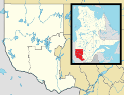 Denholm Location in western Quebec. | |
| Coordinates: 45°49′N 75°45′W / 45.817°N 75.750°WCoordinates: 45°49′N 75°45′W / 45.817°N 75.750°W[1] | |
| Country |
|
| Province |
|
| Region | Outaouais |
| RCM | La Vallée-de-la-Gatineau |
| Constituted | February 27, 1924 |
| Government[2] | |
| • Mayor | Gaétan Guindon |
| • Federal riding | Pontiac |
| • Prov. riding | Gatineau |
| Area[2][3] | |
| • Total | 199.50 km2 (77.03 sq mi) |
| • Land | 181.53 km2 (70.09 sq mi) |
| Population (2011)[3] | |
| • Total | 572 |
| • Density | 3.2/km2 (8/sq mi) |
| • Pop (2006–11) |
|
| • Dwellings | 567 |
| Time zone | EST (UTC−5) |
| • Summer (DST) | EDT (UTC−4) |
| Postal code(s) | J8N 9C8 |
| Area code(s) | 819 |
| Website |
www |
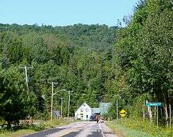
Denholm is a municipality in La Vallée-de-la-Gatineau Regional County Municipality, Quebec, Canada, 40 kilometres (25 mi) north of Gatineau. Its territory is along the eastern shores of Lake Sainte Marie, part of the Gatineau River.
Denholm is a popular location for cottage vacationing and noted for its outdoor sport and recreation opportunities, such as fishing and hunting. There are several businesses and summer camps catering to these activities.
Geography
Denholm's territory is characterized as a harmonious alternation between gently rolling hills (part of the Gatineau Hills) and numerous glacial lakes,[4] such as Cardinal, Normandeau, Plomb, Priest, Rond, and Sam Lakes. Its highest point is located in the western portion near the Gatineau River, reaching 472 meters (1,549 ft).[5]
History
Permanent settlement of the area began between 1851 and 1861. The boundaries of this township were shown on a map of 1863 by Étienne-Eugène Taché. The Denholm Township was proclaimed in 1869, taking its name from a Scottish village located north-east of Hawick in Roxburghshire.[5]
The Township Municipality of Denholm was formed in 1924 and its post office was established in 1951.[6]
During the second decade of the 20th century, Denholm's development was boosted due to the presence of asbestos, serpentine, and calcite mines. Although mining activity no longer exists today, the largest sheet of mica ever mined in the world came from one of these mines.[4]
On October 11, 2003, the Township Municipality of Denholm changed its statutes and became the Municipality of Denholm.[6]
On May 23, 2010 the City Hall was destroyed by fire. Most records were salvaged and the municipal offices were temporarily moved next door to the Volunteer Fire Hall. The municipal employees proposed that they remain in the Fire Hall despite the cramped conditions in order to save money until the new City Hall is rebuilt and use the savings to renovate the Volunteer Fire Hall which had been neglected over the years.
Demographics
Population trend:[7]
- Population in 2011: 572 (2006 to 2011 population change: -5.3 %)
- Population in 2006: 604
- Population in 2001: 526
- Population in 1996: 493
- Population in 1991: 409
Private dwellings (occupied by usual residents): 247
Languages:
- French as first language: 64.5%
- English as first language: 33.0%
- French and English as first language: 2.5%
Politics
Denholm is part of the Pontiac federal electoral district and represented by Will Amos, Liberal Party of Canada.
Provincially, it is part of Gatineau electoral district and represented by Stéphanie Vallée, member of the Quebec Liberal Party.
References
- ↑ Reference number 379122 of the Commission de toponymie du Québec (French)
- 1 2 Geographic code 83005 in the official Répertoire des municipalités (French)
- 1 2 "(Code 2483005) Census Profile". 2011 census. Statistics Canada. 2012.
- 1 2 "Denholm" (in French). MRC de La Vallée-de-la-Gatineau. Retrieved 2008-08-27.
- 1 2 "Denholm (canton)" (in French). Commission de toponymie du Québec. Retrieved 2008-08-27.
- 1 2 "Denholm (Municipalité de canton)" (in French). Commission de toponymie du Québec. Retrieved 2008-08-27.
- ↑ Statistics Canada: 1996, 2001, 2006, 2011 census
 |
Kazabazua | Lac-Sainte-Marie | | |
| Low | |
Bowman | ||
| ||||
| | ||||
| La Pêche, Val-des-Monts |
| Cities | |
|---|---|
| Municipalities | |
| Townships | |
| Unorganized territories | |
| |