Derry, New Mexico
| Derry | |
|---|---|
| Unincorporated community | |
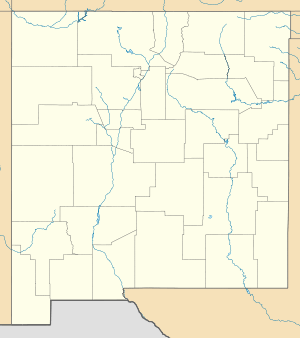 Derry  Derry Location within the state of New Mexico | |
| Coordinates: 32°47′17″N 107°16′56″W / 32.78806°N 107.28222°WCoordinates: 32°47′17″N 107°16′56″W / 32.78806°N 107.28222°W | |
| Country | United States |
| State | New Mexico |
| County | Sierra |
| Elevation | 4,117 ft (1,255 m) |
| Time zone | Mountain (MST) (UTC-7) |
| • Summer (DST) | MDT (UTC-6) |
| Area code(s) | 575 |
| GNIS feature ID | 888335[1] |
Derry is an unincorporated community located in Sierra County, New Mexico, United States. Derry is located on New Mexico State Road 187 11.3 miles (18.2 km) northwest of Hatch. Derry has a post office with ZIP code 87933, which opened on August 11, 1911.[2][3]
References
- ↑ "Derry". Geographic Names Information System. United States Geological Survey.
- ↑ "Postmaster Finder - Post Offices by ZIP Code". United States Postal Service. Retrieved November 9, 2014.
- ↑ United States Postal Service. "USPS - Look Up a ZIP Code". Retrieved November 9, 2014.
Municipalities and communities of Sierra County, New Mexico, United States | ||
|---|---|---|
| Cities | 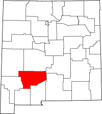 | |
| Villages | ||
| CDPs | ||
| Other communities | ||
| Ghost towns | ||
This article is issued from Wikipedia - version of the 8/7/2016. The text is available under the Creative Commons Attribution/Share Alike but additional terms may apply for the media files.