Devil's Lake State Park (Wisconsin)
- This is about the state park in Wisconsin. For parks with similar names, see Devil's Lake State Park (disambiguation)
| Devil's Lake State Park | |
| Wisconsin State Park | |
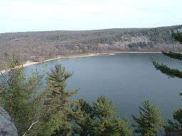 Devil's Lake from the West Bluff | |
| Country | |
|---|---|
| State | |
| County | Sauk |
| Location | Baraboo |
| - elevation | 1,329 ft (405 m) [1] |
| - coordinates | 43°24′53″N 89°42′47″W / 43.41472°N 89.71306°WCoordinates: 43°24′53″N 89°42′47″W / 43.41472°N 89.71306°W |
| Area | 9,217 acres (3,730 ha) |
| Founded | 1911 |
| Management | Wisconsin Department of Natural Resources |
| Unit of | Ice Age National Scientific Reserve |
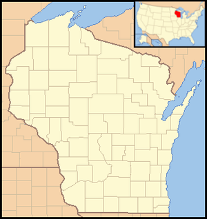 Location of Devil's Lake State Park in Wisconsin
| |
Devil's Lake State Park is a state park located in the Baraboo Range in eastern Sauk County, just south of Baraboo, Wisconsin. Devil's Lake State Park is the biggest state park in Wisconsin.[2] It is around thirty-five miles northwest of Madison, and is on the western edge of the last ice-sheet deposited during the Wisconsin drift.[3] This 9,217-acre (3,730 ha)[4] state park is known for its 500-foot-high (150 m) quartzite bluffs along the 360-acre (150 ha) Devil's Lake, which was created by a glacier depositing terminal moraines that plugged the north and south ends of the gap in the bluffs during the last ice age approximately 12,000 years ago. The sand at the bottom of Devil's Lake is thought to be deposited by glaciers. Devil's Lake is situated in the Baraboo Hills. The Baraboo Hills are thought to be much older than Devil's Lake itself; they are approximately 1.6 billion years old and were once part of the Baraboo Range which is thought to have been taller than the Rocky Mountains.
In 1974, the National Park Service declared the Southern portion of the Baraboo Hills a National Natural Landmark. The Nature Conservancy also designated it as one of the Last Great Places; it is one of only 77 of these places in the world.[2] Loess covers most of the hills and forms the parent material of a brown silt loam soil. During the autumn, the park's brilliant foliage makes it a popular attraction. The lake is surrounded by a mixed conifer-deciduous forest and the Baraboo Hills are also home to one of the largest contiguous hardwood forests in the Midwest.[2] Its scenic beauty along with its proximity to the Wisconsin Dells has made it one of the most popular of Wisconsin's state parks for both day use and overnight camping; the park receives over 1.2 million visitors annually.
Due to the long geological history of Devil's Lake and the Baraboo Range, the area has been used in geological research for years. The lake itself is rectangular in shape and is a little over a mile long from north to south and a half mile from east to west. It has many cliffs, waterfalls, unique rock formations and a variety of animal and plant species.[5] One of the most notable features of the park is the presence of large talus slopes on three sides of the lake.
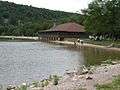
Both the north and south shores have food courts and modern restroom facilities. The park has trails ranging from handicapped accessible paved trails to difficult hiking or bouldering trails. There are also designated rock climbing areas for all levels of experienced climbers. There are also bike trails available. Devil's Lake State Park contains eight miles of off-road bike trails and a two-mile paved path that is available for people with disabilities. There are three popular campgrounds at the park containing 407 campsites all together, one of which contains a sledding hill.[2] There are many quartzite rock formations, such as Balanced Rock and Devil's Doorway, throughout the park. Effigy mounds are also located throughout the park. The park contains approximately twelve miles of the 1,200-mile (1,900 km) Ice Age Trail.
Parfrey's Glen, Wisconsin's first state natural area, is managed by the Devil's Lake State Park and located just east of the park.
Nearby attractions include Devil's Head Resort, Cascade Mountain Resort, and the Circus World Museum.
History
The area where the park now stands was first settled by pioneers in the mid-1800s. By the start of the 20th century, the area had become a popular vacation destination for wealthy families from Chicago and Madison. The park was founded in 1911.[6] It was home to five resorts, two of which were perched on the west bluff. No trace of any of these hotels remains. There were also many private residences in the west and south shores of the lake, only four of which remain. At various times the lakeshore hosted water slides, lodges, and golf courses. The clubhouse of one course sat on the current location of the park's nature center. By the 1940s, the hotels were all closed, and the park was retreating to its former natural self.
Visitor center
The visitor center houses a three-dimensional model of the park from a top-down view.
Nature center

The exhibits at the park's nature center focus on the geology and natural history of the area. Public nature programs are offered in the summer, as well as evening programs on Saturday nights in the Northern Lights Amphitheater. The nature center also has many historical photographs that come from as far back as the 1800s. They also have many displays of examples of the flora and fauna that can be found throughout the park.[2]
Glacial features
North Glacial Moraine is well covered by the north shore developments. The parking lots, concession building and the picnic shelter all sit atop the moraine. This moraine forms the northern border of Devil's Lake.[7] The moraine is approximately 80 feet (24 m) thick.[8]
Southeast Glacial Moraine – is located between the East Bluff-South Face and the South Bluff. The Group Camp is located atop the moraine. It is best seen from the Roznos Meadow parking area along State Route 113.[7] The moraine is approximately 130 feet (40 m) thick.[8]
-

Southeast moraine between the South Bluff and the East Bluff-South Face
-
The "Chateau" atop the North Glacial Moraine
-

Devil's Doorway rock formation.
Mounds
The park has several American Indian mounds. Most are extremely small. Across the parking lot from the nature center are effigy mounds built in stylized animal shapes, such as a lynx and a sparrow. In front of the concession building is a linear mound, one of several geometric mounds in the park. These mounds were used as an ancient burial site by early North Americans. The nature center offers specific courses designed to teach individuals about the history of the effigy mounds.[9][10]
-

Linear mound near the concession building
-

Lynx mound near the nature center
-

Even when discovered, the mounds were small
Baraboo Range
The Baraboo Range National Natural Landmark is 50,700 acres (20,500 ha) in southern Wisconsin. It is an exhumed mountain range consisting of the largest contiguous forest in southern Wisconsin.[11] The range is largely composed of Baraboo quartzite and is divided in half by Devil's Lake. The highest point of the range is 1620 feet.[3]
Hiking Trails
- Balanced Rock Trail (0.4 miles (0.64 km), 45 min.) – Difficult
- CCC Trail (0.3 miles (0.48 km), 45 min.) – Difficult
- Devil's Doorway Trail (0.1 miles (0.16 km), 15 min.) – Easy
- East Bluff Trail (1.7 miles (2.7 km), 1½ hrs.) – Medium
- East Bluff Woods Trail & Loop (3.4 miles (5.5 km), 2½ hrs.) – Easy/Medium
- Grottos Trail (0.7 miles (1.1 km), 31 min.) – Easy
- Potholes Trail (0.3 miles (0.48 km), 30 min.) – Difficult
- Tumbled Rocks Trail (1.0 mile (1.6 km), 45 min.) – Easy
- West Bluff Trail (1.4 miles (2.3 km), 1½ hrs.) – Medium
- Johnson Moraine Loop Trail (2.8 miles (4.5 km), 1½ hrs.) – Easy
- Steinke Basin Loop Trail (2.4 miles (3.9 km), 1½ hrs.) – Easy
- Upland Loop Trail (3.8 miles (6.1 km), 2¾ hrs.) – Medium
- Parfrey's Glen Trail (0.7 miles (1.1 km), 1 hr.) – Easy/Medium
- Ice Age Trail Entire Loop (13.7 miles (22.0 km), 8-10 hrs.) – Medium/Difficult
- Sauk Point Trail (4.5 miles (7.2 km), 3½ hrs.) – Medium/Difficult
- Roznos Meadow Trail (1.8 miles (2.9 km), 1 2/4 hrs.) – Easy/Medium
There is a total of 41 miles (66 km) of hiking trails in the park. At the highest point, you are 500 feet (150 m) above Devil's Lake. Be watchful for loose footing and steep drop offs.[12]
Rock climbing
The geology of the Baraboo Hills surrounding Devil's Lake makes it one of the premier rock climbing areas in the Midwest, with climbs of varying difficulty. The Baraboo Hills are primarily granite and quartzite, which is solid enough to climb. Most outcroppings in the region, especially in the Driftless Area, are composed of sandstone or limestone, which are too brittle to climb safely.
-

Beach on south end of Devil's Lake
-

Chimney Rock
-

Boulder field on Eastern bluff at Devil's Lake
-

View of Baraboo Hills from top of one of the mountains
See also
References
Citations:
- ↑ "Devils Lake State Park". Geographic Names Information System. United States Geological Survey. 1980-08-29. Retrieved 2011-03-18.
- 1 2 3 4 5 "Regional & Property Analysis: Sauk Prairie Recreation Area". July 2012: 1–67.
- 1 2 Salisbury, Rollin; Wallace Walter Atwood (1897). "Drift Phenomena in the Vicinity of Devil's Lake and Baraboo, Wisconsin". The Journal of Geology. 5 (2): 131–147. Bibcode:1897JG......5..131S. doi:10.1086/607730.
- ↑ "Pick a Park – WDNR". Wisconsin Department of Natural Resources. Retrieved 2009-01-25.
- ↑ Trowbridge, Arthur (1917). "The History of Devil's Lake, Wisconsin". The Journal of Geology. 25. 25 (4): 344–372. Bibcode:1917JG.....25..344T. doi:10.1086/622484.
- ↑ Wisconsin Department of Natural Resources. "Devil's Lake State Park 100 Years of Stories".
- 1 2 Devil's Lake State Park, Landmark Nature Trail; Baraboo, Wisconsin, 2008
- 1 2 Devil's Lake State Park, West Bluff Self-Guide Tour; Baraboo, Wisconsin, 2008
- ↑ Wisconsin Department of Natural Resources (2011-01-05). "Effigy Mounds of Devil's Lake".
- ↑ Wayside exhibits located by each mound
- ↑ Final Environmental Impact Statement-Badger Army Ammunition Plant
- ↑ Map and Trail Guide to Devil's Lake State Park, baraboo, Wisconsin; 2004
See also:
- Lange, Kenneth I. (1989), Ancient Rocks and Vanished Glaciers: A Natural History of Devil's Lake State Park, Wisconsin; Stevens Point, Wisconsin: Worzalla Publishing Company.
Bagg, Alan R. (1978), 50 Short Climbs in the Midwest https://openlibrary.org/works/OL6693475W/50_short_climbs_in_the_Midwest, p. 63, 139
External links
| Wikimedia Commons has media related to Devil's Lake State Park. |