Dickson, Australian Capital Territory
| Dickson Canberra, Australian Capital Territory | |||||||||||||
|---|---|---|---|---|---|---|---|---|---|---|---|---|---|
 Woolley St | |||||||||||||
 | |||||||||||||
| Coordinates | 35°15′09″S 149°08′23″E / 35.25250°S 149.13972°ECoordinates: 35°15′09″S 149°08′23″E / 35.25250°S 149.13972°E | ||||||||||||
| Population | 2,139 (2011 census)[1] | ||||||||||||
| • Density | 1,340/km2 (3,460/sq mi) | ||||||||||||
| Established | 1928 | ||||||||||||
| Postcode(s) | 2602 | ||||||||||||
| Area | 1.6 km2 (0.6 sq mi) | ||||||||||||
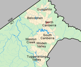
| District | North Canberra | ||||||||||||
| Territory electorate(s) | Kurrajong | ||||||||||||
| Federal Division(s) | Fenner | ||||||||||||
| |||||||||||||
Dickson (postcode: 2602) is a suburb in the Inner North of Canberra, Australia. It is named after Sir James Dickson (1832–1901) who was a Queensland advocate of Australian Federation and one of the founders of the Australian Constitution. There is no specific theme for street names.[2]
History
Between 1926 and 1928, a small runway called Northbourne Aviation Ground was located where the Dickson Library and playing fields are now. This was Canberra's original airport. Dickson was gazetted on 28 September 1928, but the suburb was not settled until the 1960s.[3]
Geography
The suburb is bounded by Northbourne Avenue, Antill Street, Phillip Avenue, Majura Avenue, Limestone Avenue and Wakefield Avenue. Dickson contains no hills or significant slopes. The east arm of Sullivans Creek passes through the middle of Dickson draining storm water from east to west.
Amenities
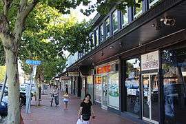
The suburb contains the Dickson Centre, a significant commercial centre in Canberra’s Inner North containing the Woolworths Supermarkets outlet with the greatest turnover in Australia. The centre contains an ambulance station, office buildings, many shops and the Dickson Baptist Church.[4]
Outside the Dickson Centre, the suburb contains the Australian Broadcasting Corporation Canberra radio and television studios. Two colleges are located in the suburb, Dickson College, a public senior secondary school, and Daramalan College, a Catholic high school. The Daramalan Junior school was once located in Dickson, which operated between 1986 and 1997. It was a school for boys in years 5 and 6, and was near St. Brigid's Church.
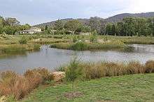
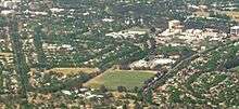
Dickson has large playing fields with several ovals, which are used to play many sports including soccer, cricket and rugby, as well as the venue for schools carnivals, and are a popular place on weekends. Organisations calling the playing fields home including the Majura Junior Soccer Club and Corroboree Little Athletics. Near the playing fields is a walking track between rows of pine, oak and gum trees which leads to the Dickson shopping centre. Hawdon Street is where the Canberra Space Dome and Observatory used to be located before being destroyed by fire in 2010. The street is cut in half by the eastern branch of Sullivans Creek, which runs in a concrete drain. On the south side of Sullivans Creek at this point is the Dickson Wetlands, which was completed in December 2011.[5]
Character
The suburb is characterised by leafy streets, detached single dwelling houses, and double story duplex townhouses. The western part of the suburb is beginning to be redeveloped under a policy permitting two and three-storey flats.[6] Redevelopment with eight to ten-storey flats is permitted on properties near Northbourne Avenue and one such block of flats has been built near the ABC studios.[7]
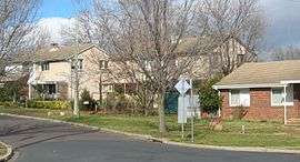 A residential street in Dickson |
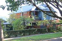 New town houses in Dooring St |
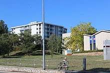 New 8-storey flats near Northbourne Avenue |
Demographics
In the 2011 Census, the population of Dickson was 2,139, including 42 (2.0%) Indigenous persons and 1,451 (67.8%) Australian-born persons. 57.1% of dwellings were separate houses (compared to the Australian average of 75.6%), while 22.5% were semi-detached, row or terrace houses (Australian average: 9.9%) and 20.3% were flats, units or apartments (Australian average: 13.6%). 37.8% of the population were professionals, compared to the Australian average of 21.3%. Notably 21.4% worked in government administration, compared to the Australian average of 1.3%, although the Canberra-wide average is a very similar 20.1%. O'Connor is favoured by students and young adults with 17.4% of its population in the 15- to 24-year-old age group (compared to the Australian average of 13.3%). 38.6% of the population had no religion, compared to the ACT average of 28.9% and the Australian average of 22.3%.[1]
67.8% of people living in the suburb of Dickson were born in Australia. The other top responses for country of birth were 3.9% China, 3.4% England, 1.4% New Zealand, 1.1% India, 1.1% United States of America, 1.0% Indonesia, 0.9% Vietnam, 0.8% Germany, 0.8% Greece, 0.7% Netherlands, 0.6% Ireland, 0.5% Korea, Republic of, 0.5% Italy, 0.5% Austria.
75.5% of people living in Dickson speak English only. The other top languages spoken are 4.6% Language spoken at home not stated, 3.1% Mandarin, 2.7% Other, 1.4% Cantonese, 1.2% Vietnamese, 1.1% Greek, 1.0% German, 1.0% Indonesian, 0.9% Italian.
Politics
| ||||||||||||||||||||||||||||||||||||
Dickson is located within the federal electorate of Fenner and it is represented by Andrew Leigh for the Labor Party. In the ACT Legislative Assembly, Dickson is part of the electorate of Kurrajong, which elects five members on the basis of proportional representation, two Labor, two Liberal and one Greens.[10] Polling place statistics are shown to the right for the Dickson polling place at Daramalan College in the 2016 federal[8] and 2016 ACT[9] elections.
Geology
Calcareous shales from the Canberra Formation dates from the Silurian period. This rock is the limestone of the original title of Canberra "Limestone Plains". Quaternary alluvium lies on top of the shale in the flatter parts of Dickson.[11]

Footnotes
- 1 2 Australian Bureau of Statistics (31 October 2012). "Dickson (State Suburb)". 2011 Census QuickStats. Retrieved 29 December 2013.
- ↑ "Suburb Name search results". ACT Environment and Sustainable Development. Retrieved 23 February 2014.
- ↑ Conroy, Susan (April 1998). "Dickson Shopping Centre Refurbishment Project". tomw.net.au. Retrieved 23 February 2014.
- ↑ "Dickson Baptist Church". Retrieved 23 February 2014.
- ↑ "Dickson and Lyneham Wetlands". ACT Environment and Sustainable Development Directorate. Retrieved 10 March 2014.
- ↑ "Inner North Precinct Code" (PDF). ACT Planning and Land Authority. 29 November 2013. Retrieved 23 February 2014.
- ↑ "Northbourne Avenue Precinct Code" (PDF). ACT Planning and Land Authority. 18 December 2012. Retrieved 23 February 2014.
- 1 2 "Federal Election 2016 - Polling Place Dickson". Australian Electoral Commission. 15 July 2016. Retrieved 12 November 2016.
- 1 2 "2016 Results for Kurrajong Candidates at Dickson Polling Place". ACT Electoral Commission. 12 November 2016. Retrieved 12 November 2016.
- ↑ "Current members". ACT Legislative Assembly. Retrieved 12 November 2016.
- ↑ Henderson G A M and Matveev G, Geology of Canberra, Queanbeyan and Environs 1:50000 1980.
References
| Wikimedia Commons has media related to Dickson, Australian Capital Territory. |