Digoin
| Digoin | ||
|---|---|---|
|
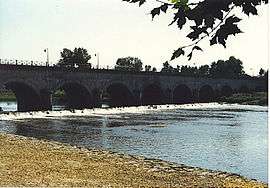
Water bridge on the Loire River near Digoin | ||
| ||
 Digoin | ||
|
Location within Bourgogne-Franche-Comté region  Digoin | ||
| Coordinates: 46°28′58″N 3°58′53″E / 46.4828°N 3.9814°ECoordinates: 46°28′58″N 3°58′53″E / 46.4828°N 3.9814°E | ||
| Country | France | |
| Region | Bourgogne-Franche-Comté | |
| Department | Saône-et-Loire | |
| Arrondissement | Charolles | |
| Canton | Digoin | |
| Intercommunality | Digoin Val de Loire | |
| Government | ||
| • Mayor (2001–2008) | Maxime Castagna | |
| Area1 | 34.72 km2 (13.41 sq mi) | |
| Population (2006)2 | 8,856 | |
| • Density | 260/km2 (660/sq mi) | |
| Time zone | CET (UTC+1) | |
| • Summer (DST) | CEST (UTC+2) | |
| INSEE/Postal code | 71176 / 71160 | |
| Elevation |
222–306 m (728–1,004 ft) (avg. 233 m or 764 ft) | |
|
1 French Land Register data, which excludes lakes, ponds, glaciers > 1 km² (0.386 sq mi or 247 acres) and river estuaries. 2 Population without double counting: residents of multiple communes (e.g., students and military personnel) only counted once. | ||

Digoin is a commune in the Saône-et-Loire department in the region of Bourgogne in eastern France.
The junction of the Canal du Centre and the Canal latéral à la Loire is near Digoin.
Geography
The Bourbince river flows into the Arroux in Digoin, while the Arroux Rivers flows into the Loire.
Notable people
- Adolphe Piot(c. 1825 – c. 1910), French painter
- Alain Robert (born 1962), French rock climber and urban climber
See also
References
External links
| Wikimedia Commons has media related to Digoin. |
This article is issued from Wikipedia - version of the 10/28/2016. The text is available under the Creative Commons Attribution/Share Alike but additional terms may apply for the media files.