La Clayette
| La Clayette | |
|---|---|
|
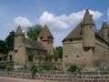
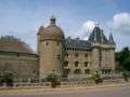
Castle of La Clayette | |
 La Clayette | |
|
Location within Bourgogne-Franche-Comté region  La Clayette | |
| Coordinates: 46°17′26″N 4°18′20″E / 46.2906°N 4.3056°ECoordinates: 46°17′26″N 4°18′20″E / 46.2906°N 4.3056°E | |
| Country | France |
| Region | Bourgogne-Franche-Comté |
| Department | Saône-et-Loire |
| Arrondissement | Charolles |
| Canton | La Clayette |
| Intercommunality | Pays clayettois |
| Government | |
| • Mayor | Hugues Godard |
| Area1 | 3.12 km2 (1.20 sq mi) |
| Population (2006)2 | 2,014 |
| • Density | 650/km2 (1,700/sq mi) |
| Time zone | CET (UTC+1) |
| • Summer (DST) | CEST (UTC+2) |
| INSEE/Postal code | 71133 / 71800 |
| Elevation |
336–437 m (1,102–1,434 ft) (avg. 385 m or 1,263 ft) |
|
1 French Land Register data, which excludes lakes, ponds, glaciers > 1 km² (0.386 sq mi or 247 acres) and river estuaries. 2 Population without double counting: residents of multiple communes (e.g., students and military personnel) only counted once. | |
.JPG)
La Clayette is a commune in the Saône-et-Loire department in the region of Bourgogne in eastern France.
Geography
La Clayette is situated in the Brionnais area, in the south-west of the Saône-et-Loire département.
Access
- By road: the town is situated at the crossroads of the routes D985 and D987, 40 km from Roanne, 60 km from Mâcon, 90 km from Lyon and 100 km from Moulins.
- By rail: La Clayette-Baudemont station stands on the line from Lyon to Paray-le-Monial. It is served by the TER train which takes 1 hour 20 minutes from Lyon.
History
- 1435 : Creation of the borough of La Clayette by the Chantemerle family
- 1437 : Creation of the fairs
- 1450 : Creation of the markets
- 1632 : Alice de Chantemerle, last descendant of the family of the same name, founded by will the convent of the Minimes (in the building which is now the Mairie (Town Hall))
- Until the French Revolution, La Clayette was governed from Varennes-sous-Dun
Demography
| Year | 1962 | 1968 | 1975 | 1982 | 1990 | 1999 | 2006 |
|---|---|---|---|---|---|---|---|
| Population | 2173 | 2530 | 2845 | 2669 | 2307 | 2069 | 2012 |
| From the year 1962 on: No double counting—residents of multiple communes (e.g. students and military personnel) are counted only once. | |||||||
Places and monuments
Château de La Clayette

_-_1.JPG)

Chapelle Sainte Avoye
The construction of Sainte Avoye's chapel, in the flamboyant gothic style, was due to Louis de Chantemerle in the fifteenth century.
Twin towns – Sister cities
 Göllheim, Germany
 Marano Equo, Italy
Tourism
Main article: Tourism in Saône-et-Loire
In Bourgogne-Franche-Comté, you can see :
- The Arboretum de Pézanin, one of the richest forest collection in France, near La Clayette,
- The Rock of Solutré,
- The Cluny abbey, and its medieval city,
- Charolles and the "boeuf charolais",
- Mâcon, Paray-le-Monial,...
See also
References
| Wikimedia Commons has media related to La Clayette. |
This article is issued from Wikipedia - version of the 10/28/2016. The text is available under the Creative Commons Attribution/Share Alike but additional terms may apply for the media files.