Dreher Township, Wayne County, Pennsylvania
| Dreher, Pennsylvania | |
|---|---|
| Second-class township | |
| Township of Dreher | |
|
| |
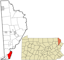 Location in Wayne County and the state of Pennsylvania. | |
| Country | United States |
| State | Pennsylvania |
| US Congressional District | PA-10 |
| State Senatorial District | 20 |
| State House of Representatives District | 115 |
| County | Wayne |
| School District | Wallenpaupack Area |
| Settled | c. 1794[3] |
| Incorporated | September 7, 1877[3] |
| Founded by | Denman Coe[3] |
| Named for | Samuel S. Dreher[4] |
| Government | |
| • Type | Board of Supervisors |
| • Board of Supervisors[5] |
Supervisors
|
| • US Representative | Tom Marino (R) |
| • State Senator | Lisa Baker (R) |
| • State Representative | Frank Farina (D) |
| Area | |
| • Total | 15.1 sq mi (39 km2) |
| • Land | 14.85 sq mi (38.5 km2) |
| • Water | 0.25 sq mi (0.6 km2) |
| Elevation | 1,791 ft (546 m) |
| Population (2010) | |
| • Total | 1,412 |
| • Density | 95.1/sq mi (36.7/km2) |
| Time zone | Eastern (EST) (UTC-5) |
| • Summer (DST) | Eastern Daylight (EDT) (UTC-4) |
| Area code(s) | 570 & 272 |
| GNIS feature ID | 1217218[6] |
| FIPS code | 42-127-19864[7] |
Dreher is a second-class township in Wayne County, Pennsylvania. The township's population was 1,412 at the time of the 2010 United States Census.[8]
History
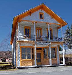
The Bridge in Dreher Township and Patriotic Order Sons of America Washington Camp 422 are listed on the National Register of Historic Places.[9][10]
Geography
According to the United States Census Bureau,[11] the township has a total area of 15.1 square miles (39 km2), of which, 14.85 square miles (38.5 km2) of it is land and 0.25 square miles (0.65 km2) of it (1.66%) is water.
Communities
The following villages are located in Dreher Township:
In addition, the township is also home to one private community, Breezewood Acres.[12][17]
Demographics
As of the census of 2010, there were 1,412 people, 542 households, and 358 families residing in the township. The population density was 95.1 people per square mile (36.7/km²). There were 703 housing units at an average density of 47.3/sq mi. The racial makeup of the township was 95.6% White, 2.1% African American, 0.3% Native American, 0.4% Asian, 0.1% Pacific Islander, 0.5% from other races, and 1% from two or more races. Hispanic or Latino of any race were 4.9% of the population.
There were 542 households out of which 27.7% had children under the age of 18 living with them, 53.3% were married couples living together, 7.2% had a female householder with no husband present, and 33.9% were non-families. 28.4% of all households were made up of individuals and 13.3% had someone living alone who was 65 years of age or older. The average household size was 2.44 and the average family size was 2.98.
In the township the population was spread out with 20% under the age of 18, 63.1% from 18 to 64, and 16.9% who were 65 years of age or older. The median age was 45.6 years.
The median income for a household in the township was $32,639, and the median income for a family was $42,708. Males had a median income of $31,989 versus $22,109 for females. The per capita income for the township was $15,945. About 9.7% of families and 12.2% of the population were below the poverty line, including 16.3% of those under age 18 and 9.5% of those age 65 or over.
References
- ↑ "Ella C. Ehrhardt General Store". Wayne County Historical Society. Wayne County Historical Society. 2014. Retrieved 8 December 2014.
- ↑ "Ella C. Ehrhardt General Store". Wayne County Historical Society. Wayne County Historical Society. 2014. Retrieved 8 December 2014.
- 1 2 3 "Dreher Township". Wayne County Historical Society. Wayne County Historical Society. 2014. Retrieved 8 December 2014.
- ↑ Goodrich, Phineas G. (1992) [1880]. History of Wayne County. Baltimore: Gateway Press, Inc. p. 285.
- ↑ "Municipal Index" (PDF). Wayne County Planning Commission/GIS. WordPress. 2011. Retrieved 8 December 2014.
- ↑ "Township of Dreher". Geographic Names Information System. United States Geological Survey. 1 December 1989. Retrieved 8 December 2014.
- ↑ U.S. Census Bureau. Census 2000. "Census Demographic Profiles, Dreher Township" (PDF). CenStats Databases. Retrieved 8 December 2014.
- ↑ "American FactFinder". United States Census Bureau. Retrieved 2011-05-14.
- ↑ National Park Service (2010-07-09). "National Register Information System". National Register of Historic Places. National Park Service.
- ↑ "National Register of Historic Places Listings". Weekly List of Actions Taken on Properties: 12/27/10 through 12/30/10. National Park Service. 2011-01-07.
- ↑ "US Gazetteer files: 2010, 2000, and 1990". United States Census Bureau. 2011-02-12. Retrieved 2011-04-23.
- 1 2 3 4 5 6 "DREHER: SECOND CLASS TOWNSHIP MAP" (PDF). Pennsylvania Department of Transportation. Commonwealth of Pennsylvania. 28 May 2013. Retrieved 9 December 2014.
- ↑ "Angels". Geographic Names Information System. United States Geological Survey. 2 August 1979. Retrieved 9 December 2014.
- ↑ "East Sterling". Geographic Names Information System. United States Geological Survey. 2 August 1979. Retrieved 9 December 2014.
- ↑ "Haags Mill". Geographic Names Information System. United States Geological Survey. 2 August 1979. Retrieved 9 December 2014.
- ↑ "South Sterling". Geographic Names Information System. United States Geological Survey. 2 August 1979. Retrieved 9 December 2014.
- ↑ "Breezewood Acres Community Association". Breezewood Acres Community Association. Breezewood Acres Community Association. 2014. Retrieved 9 December 2014.
External links
Municipalities and communities of Wayne County, Pennsylvania, United States | ||
|---|---|---|
| Boroughs | 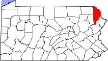 | |
| Townships | ||
| CDPs | ||
| Unincorporated communities | ||