Driedmeat Lake (Alberta)
| Driedmeat Lake | |
|---|---|
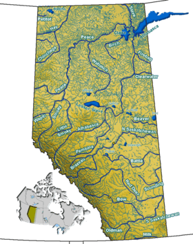
 Driedmeat Lake Loaction of Driedmeat Lake in Alberta | |
| Location | Camrose County, Alberta |
| Coordinates | 52°51′53″N 112°44′59″W / 52.86472°N 112.74972°WCoordinates: 52°51′53″N 112°44′59″W / 52.86472°N 112.74972°W |
| Type | Lake |
| Primary inflows | Battle River |
| Primary outflows | Battle River |
| Basin countries | Canada |
| Max. length | 15.6 km (9.7 mi) |
| Max. width | 0.9 km (0.56 mi) |
| Surface area | 16.5 km2 (6.4 sq mi) |
| Average depth | 2.2 m (7 ft 3 in) |
| Max. depth | 3.7 m (12 ft) |
| Water volume | 41,900,000 m3 (1.48×10⁹ cu ft) |
| Residence time | 0.25 years |
| Shore length1 | 41.2 km (25.6 mi) |
| Surface elevation | 684.44 m (2,245.5 ft) |
| Settlements | Tillicum Beach |
| References | [1] |
| 1 Shore length is not a well-defined measure. | |
Driedmeat Lake is a long ribbon lake in Alberta; part of the Battle River system. It lies south of the city of Camrose. The city draws its water supply from the lake.[2][3] It was originally created by a glacial meltwater channel, which carved the surrounding valley. In the valley and around it, Saskatoon berries, an ingredient of pemmican, grow and are endemic in the area.
History
Before Europeans settled on the land, the Blackfoot tribe and Cree native's would use the area around the lake to camp and hunt. The resulting name of "Driedmeat" comes from the Cree word for drying Bison meat and making pemmican. A nearby hill was the origin of the lake's name, the hill's name itself is Driedmeat. Which is now disrupted by gravel extraction operations.
In 1885, Joseph Tyrrell described a Metis settlement of forty families along the Battle River four miles from Driedmeat lake. They lived in "substantial log houses." Their cultivation of crops allowed them to be self-sustaining. Crops included wheat, barley, oats, potatoes, turnips, and Indian corn. Live stock included horses, cattle and sheep; all healthy, Tyrrell observed.[4][5]
Natural history
Driedmeat Lake is considered a highly eutrophic lake.
Flora
The most common aquatic plant of Driedmeat Lake is a blue-green algal bloom. Aquatic macrophytes are another notable feature of Driedmeat Lake, especially in the northern and southern thirds of the lake. Aquatic plants form mats on the surface and make it difficult for boats to travel.
Fourteen species of aquatic macrophytes were identified by Alberta Environment during a 1984 survey of Driedmeat Lake. The most abundant plants were pondweeds (Potamogeton richardsonii, P. vaginatus and P. pectinatus) and coontail (Ceratophyllum demersum).
Fauna
Driedmeat Lake provides important nesting habitat for waterfowl and is an important fall staging area for swans and Canada geese. Flocks of White Pelicans feed on the lake.
In 1939, the provincial government was petitioned to have the lake classified as a bird sanctuary (Gould 1939). The region is now a Restricted Wildlife Area, which means that hunting of waterfowl and upland game birds is not allowed within 0.8 km of the lake until 1 November each year. From November until the end of hunting season, hunting is permitted to encourage waterfowl to continue their migration.[1]
Frank Farley published the Birds of the Battle River Region in 1932. He owned a farm located alongside Driedmeat Lake. He writes of his own sighting of birds on his property.[6]
Fish
Driedmeat Lake is popular for angling for northern pike in summer and for ice-fishing in winter. Other species found in the lake include longnose dace, lake chub, emerald shiner, spottail shiner, white sucker and brook stickleback. Fish and Wildlife officials estimate that there are 46,800 ± 18,000 pike in the lake.
Resoures use
Driedmeat Lake provides water for the city of Camrose. On a typical day, the people of Camrose use 5.5 million litres of water.[3] In 2010, the level of the lake was raised just over half a meter. A new steel sheet piling weir was constructed directly upstream from the existing weir. The total cost of the project, including changes to the existing fishway, constructing of a new public access road and parking lot, was $1,178,431.15.[7]
References
- 1 2 Mitchell, Patricia; Prepas, Ellie E. (1990). Atlas of Alberta lakes. Edmonton: University of Alberta Press. ISBN 0888642156. Retrieved 7 June 2016.
- ↑ "Battle River Watershed Management, Planning Process, Phase One, Terms of Reference" (PDF). Alberta Environment. May 27, 2004. p. 15. Retrieved 2014-10-13.
- 1 2 "City of Camrose Water Systems". City of Camrose. Retrieved 2014-10-13.
- ↑ Wonders, William C. (Spring 1983). "Far Corner Of The Strange Empire Central Alberta On The Eve Of Homestead Settlement". Great Plains Quarterly, Paper 1709. Lincoln, Nebraska: Center for Great Plains Studies, University of Nebraska. 3 (2): 92–108. Retrieved 2014-10-14.
- ↑ Tyrrell, J. B. (1887). "Report E. Report on a part of Northern Alberta". Annual Report - Geological Survey of Canada. Montreal, Quebec: Dawson Brothers: 38 E. Retrieved 2014-10-14.
- ↑ Farley, Frank L. (1932). Birds of the Battle River Region of Central Alberta. Edmonton, AB: The Institute Of Applied Art, Ltd.
- ↑ "Driedmeat Lake Control Structure Modifications" (PDF). Sameng Inc. 2012. Retrieved 2014-10-14.
External links
- Approved Water Management Plan for the Battle River Basin (Alberta)
- Cyanotoxins in Canadian Waters by B.G. Kotak and R.W. Zurawell