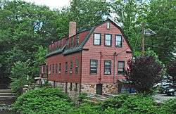
Droeschers Mill
|
Droescher's Mill | |
 | |
   | |
| Location | 347 Lincoln Avenue East, Cranford, New Jersey |
|---|---|
| Coordinates | 40°39′1″N 74°18′6″W / 40.65028°N 74.30167°WCoordinates: 40°39′1″N 74°18′6″W / 40.65028°N 74.30167°W |
| Area | 0.5 acres (0.20 ha) |
| NRHP Reference # | 74001192[1] |
| NJRHP # | 2653[2] |
| Significant dates | |
| Added to NRHP | January 8, 1974 |
| Designated NJRHP | September 18, 1973 |
Droescher's Mill is located in Cranford, Union County, New Jersey, United States. The mill was added to the National Register of Historic Places on January 8, 1974. It is the oldest continuously operated commercial building in New Jersey.[3]
Also known as the Williams-Droescher Mill, Droescher's Mill is the last remaining mill on the Rahway River. It was constructed in 1737 by Benjamin Williams as a saw mill alongside a dam. Williams used the flow of the river to turn an undershot water wheel to power his saws. Lumber cut here went into the construction of the first houses built in the area. Shortly before his death in 1779, Williams erected a second building only a few feet from his sawmill for the manufacture of woolens.[4]
In 1902, Severin R. Droescher bought the mill and renovated it into the structure as seen today. S.R. Droescher used it to run the Cranford Oil Stone Works where whetstones and oilstones were made.[5]
Lincoln Ave East and Lincoln Ave West, the road that passes through Cranford and on which the mill sits, was originally part of the Naraticong Trail, a route to the sea of the Unami tribe of the Lenape people. Lincoln Avenue was known as the Old York Road by the 1700s, a colonial road from Elizabeth to Philadelphia.
Aside from the Naraticong Trail, the Great Minisink Trail also passed through Cranford as a traditional Lenape route to collect marine foods at the shore.[6]
The Rahway River and Rahway River Parkway greenway
The mill and surrounding parkland are one of the Cranford landmarks on the Cranford portion of the Rahway River Parkway, which is an almost century-old greenway of parkland that hugs the Rahway River and its tributaries throughout Union County, New Jersey. It was designed in the 1920s by the well-known Olmsted Brothers firm, sons of the eminent landscape architect Frederick Law Olmsted.
The Cranford section follows the banks of the meandering Rahway River as it flows south through Lenape Park, Nomahegan Park,[7] Hampton Park, MacConnell Park, Girl Scout Park, the Cranford Canoe Club, Hanson Park,;[8] Sperry Park, Crane's Park, Droeschers Mill Park (also known as Squire Williams Park),[9] and Mohawk Park.[10]
The "Friends of Rahway River Parkway," a nonprofit group, has been formed exclusively to encourage and advocate for the preservation, restoration and enhancement of the Rahway River Parkway, in accord with the Olmsted design principles inherent in its origins, and to promote appropriate public enjoyment of the Parkway.[11]
Alluem Yoga, a yoga studio located in the mill, has organized Rahway River Parkway clean-ups on this stretch of the Parkway greenway at the mill.
See also
- Cranford Historical Preservation Advisory Board
- National Register of Historic Places listings in Union County, New Jersey
- List of the oldest buildings in New Jersey
- Old York Road
- Union County
References
- ↑ National Park Service (2009-03-13). "National Register Information System". National Register of Historic Places. National Park Service.
- ↑ "New Jersey and National Registers of Historic Places - Union County" (PDF). New Jersey Department of Environmental Protection - Historic Preservation Office. July 7, 2009. p. 19. Retrieved May 13, 2010.
- ↑ http://www.cranford.com/township/display.asp?choice=15
- ↑ ["Glimpse of History" http://www.nj.com/news/local/index.ssf/2009/08/glimpse_of_history_4.html]
- ↑ [American Machinist - Volume 27, Issue 1 - Page 104 https://books.google.com/books?id=er4cAQAAMAAJ]
- ↑ The Story of New Jersey's Civil Boundaries 1606 - 1968, by John P. Snyder, reprinted by the New Jersey Geological Survey, 2004, plates 2 & 3.
- ↑ Federal Writers' Project, The WPA Guide to New Jersey: The Garden State (1939) ("CRANFORD is an old residential town spread along the RAHWAY RIVER PARKWAY, a link of nearly 7 miles joining a series of county parks and playgrounds with the Essex County park system. There are facilities for summer and winter sports, a rifle range, and picnic grove. The Fourth of July canoe regatta is an annual affair. Gardens of fine old Victorian houses line the edge of the parkway on the riverbank. A broadening of the river parkway at the northern end of Cranford is known as NOMAHEGAN PARK. The name Nomahegan is a variation of Noluns Mohegans, as the New Jersey Indians were called in the treaty ending the Indian troubles in 1758. It is translated as women Mohegans or she-wolves and was applied to them in scorn by the fighting Iroquois."); Bulletin of the United States Geological Survey, Issues 112-121 (1894) (The "Nomahiggin" or "Normahiggin" is a brook in Westfield and Cranford townships, Union County, tributary to [Rahway River]).
- ↑ http://www.hansonparkconservancy.com/
- ↑ Jun 3, 1976 - http://www.digifind-it.com/cranford/DATA/newspapers/chronicle/1976/1976-06-03.pdf (opening of Squire Williams Picnic Grove in the park across the Rahway River from Droescher's Mill]]
- ↑ Friends of Rahway River Parkway http://www.rahwayriverparkway.org/the-inception-of-a-parkway.html
- ↑ http://www.rahwayriverparkway.org/
| Topics | |
|---|---|
| Lists by states |
|
| Lists by insular areas | |
| Lists by associated states | |
| Other areas | |
| |