Durrat Al Bahrain
| Native name: <span class="nickname" ">درة البحرين (Arabic) | |
|---|---|
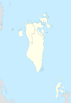 Durrat Al Bahrain Location of Durrat Al Bahrain Islands in Bahrain | |
| Geography | |
| Location | Persian Gulf |
| Coordinates | 25°50′N 50°36′E / 25.84°N 50.60°ECoordinates: 25°50′N 50°36′E / 25.84°N 50.60°E |
| Archipelago | Bahrain |
| Adjacent bodies of water | Persian Gulf |
| Total islands | 15 |
| Major islands |
|
| Area | 5.00 km2 (1.93 sq mi) |
| Highest elevation | 0 m (0 ft) |
| Administration | |
| Governorate | Southern Governorate |
Largest settlement |
Atol 1 (population 870) |
| Demographics | |
| Demonym | Bahraini |
| Population | 1000 (2010) |
| Pop. density | 200 /km2 (500 /sq mi) |
| Ethnic groups | Bahraini, non-Bahraini |
| Additional information | |
| Time zone | |
| Official website |
www |
| ISO Code = BH-14 | |
Durrat Al Bahrain (Arabic: درة البحرين) is the third largest artificial island in Bahrain after Northern City and Diyar Al Muharraq Islands. It has a distance of 40.5 km (25.2 mi) south of the capital, Manama, on Bahrain Island.
Description
Durrat Al Bahrain islands include five-star hotels, an 18-hole golf course, 12 bridges, and a marina.[1] The marina will span three of the islands and will cover a land area of approximately 0.7 km2 (7,500,000 sq ft) with a cost of about US$1.3 billion.
The marina is a joint venture between Durrat Khaleej Al Bahrain and Tameer, one of the GCC region’s leading developers. The marina development is the first of its type and size in the Middle East.
History
In 2002, plans were laid down for the project. Work began in 2004. In February 2008, work on the project was interrupted as more than 1,300 laborers downed tools in a dispute over pay. Workers who were based at a labor camp in the development site, went on strike demanding better salaries and complaining of poor living conditions.[2][3][4][5] The strike was subsequently called off soon after.[6]
Geography
The US$7 billion project consists of a series of 15 large artificial islands,[7] covering an area of about 5 km2 (54,000,000 sq ft).[8] It has six atolls, five fish-shaped islands, two crescent-shaped islands, and two more small islands related to the Marina area.
Administration
The island belongs to Southern Governorate.
Transportation
The islands have 2 causeways connecting them to Bahrain Island.
Image gallery
 Map 1
Map 1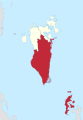 District Map
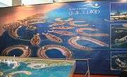 Promotional poster of the islands
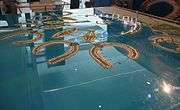 Model of Durrat Al Bahrain as seen at Cityscape Abu Dhabi 2007.
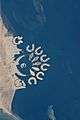 Astronaut photograph of Durrat Al Bahrain.
References
- ↑ Durrat Al Bahrain Property Development
- ↑ "Strike hits work at Durrat Al Bahrain". Tradearabia.com. 2008-02-10. Retrieved 2016-03-18.
- ↑ "1,300 migrant workers strike in Bahrain over pay". Migrant Rights. 2008-02-12. Retrieved 2016-04-18.
- ↑ PTI Feb 11, 2008, 08.59pm IST (2008-02-11). "1900 Indian workers continue strike in Bahrain - Economic Times". Articles.economictimes.indiatimes.com. Retrieved 2016-04-18.
- ↑ "Bahrain moves to settle 'illegal' strike". Alarabiya.net. 2008-02-11. Retrieved 2016-04-18.
- ↑ "Bahrain strike called off, wages raised". news.outlookindia.com. 2008-02-14. Retrieved 2016-04-18.
- ↑ Map
- ↑ Sarah Blackman (September 9, 2009). "Top 10 Bahrain mega-projects". ITP Business Publishing Ltd. Retrieved March 2, 2016.
| Wikimedia Commons has media related to Durrat Al Bahrain. |