East Dulwich
| East Dulwich | |
 East Dulwich |
|
| Population | 12,321 (2011 Census. Ward)[1] |
|---|---|
| OS grid reference | TQ345745 |
| London borough | Southwark |
| Ceremonial county | Greater London |
| Region | London |
| Country | England |
| Sovereign state | United Kingdom |
| Post town | LONDON |
| Postcode district | SE22 |
| Dialling code | 020 |
| Police | Metropolitan |
| Fire | London |
| Ambulance | London |
| EU Parliament | London |
| UK Parliament | Dulwich and West Norwood |
| London Assembly | Lambeth and Southwark |
Coordinates: 51°27′43″N 0°05′02″W / 51.4620°N 0.0840°W
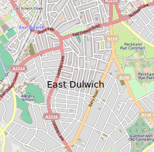
East Dulwich is a district of south London, England in the London Borough of Southwark. It forms the eastern part of Dulwich, with Peckham to the east and Camberwell to the north. This south London suburb was first developed in the nineteenth century on land owned by Alleyn's College.[2]
It was originally part of the much larger, historic parish of Camberwell, which later became the Metropolitan Borough of Camberwell, and included Camberwell, Peckham, Dulwich, Nunhead, and other London districts.[3]
History
Saxon Dulwich
967 - Edgar the Peaceful granted Dilwihs to a thane named Earl Aelfheah. Dilwihs meant 'meadow where the dill grew'.[4]
Medieval East Dulwich
1066 - King William I of England is owner of Dulwich, taking the land from King Harold II of England
Part of Lordship Lane was the boundary of Dulwich Manor with Friern Manor.
1340 - The hamlet of Est Dilewissh was sold to John Leverich by William Mabuhs
Tudor Dulwich
1538 - Dulwich no longer property of Bermondsey Abbey with Dissolution.
1544 - Dulwich granted to goldsmith Thomas Calton for £609 by Henry VIII.
Stuart East Dulwich
Georgian Dulwich
1805 (+1814) - Dulwich Common enclosed.
1826 - East Dulwich Chapel built at start of Lordship Lane opposite Goose Green.
Victorian Dulwich
1851 - Dulwich's population: 1,632.
1863 - London, Chatham and Dover Railway built.
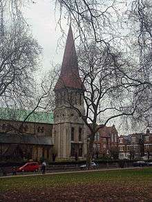
1865 - St John's Church built amidst green fields.
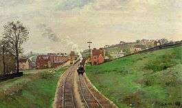
1868 - East Dulwich railway station opened as Champion Hill Station.
1868 - Old village green is bought for public use.
1871-1881 - 5,000 houses built in East Dulwich.
1872 - St John's & St Clements school moved to North Cross Road.
1874 - St Peter's Church built.
1877 - Emmanuel Congregational Church opened on Barry Road.
1882 - Heber Road School.
1885 - Horse-drawn trams arrived in East Dulwich
1887 - Dulwich Hospital opened.
1890 - Dulwich Park opened. Dulwich Grove Congregational Church opened on Melbourne Grove.
1892 - Dulwich Public Baths opened on East Dulwich Road. 1893 - Dulwich Fire Station opened on Lordship Lane (closed 1947 after war damage).[5]
1897 - Dulwich Library opened.[6]
1897 - Enid Blyton was born on Lordship Lane.
Modern East Dulwich
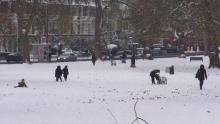
It is a residential area which has undergone gentrification in recent years.[7] There is a shopping area along Lordship Lane which, in addition to several independent shops, has a variety of restaurants, butcher, fishmonger. On Fridays and Saturdays there is a small market on North Cross Road with antiques, crafts and specialist food stalls. Some of the public houses in the area have been converted to gastropubs.
Dateline
1900 - Part of the Metropolitan Borough of Camberwell. Grove Vale School opened.
1901 - Dulwich's Population: 10,376
1902 - Imperial Hall opened in Grove Vale.
1906 - Horse-drawn trams were replaced by electrical ones. The route ran Dog Kennel Hill, Lordship Lane and East Dulwich Road.
1912 - Dulwich Hamlet FC moved to Dog Kennel Hill. Aquarius Golf Club opened.
1923 - Imperial Hall became Pavilion. Grove Tavern rebuilt.
1931 - New Dulwich Hamlet FC stadium opened.
1935 - St Thomas More Catholic Church officially named.
1938 - East Dulwich Odeon opened.
1940s - World War II: the Blitz and the V1 & V-2 rocket flying bombs caused widespread damage to East Dulwich.
1952 - End of electric trams.
1965 - Became part of new London Borough of Southwark.
1972 - East Dulwich Odeon closed. Later became London House.
1973 - Dawsons Heights by Kate Macintosh
1977 - East Dulwich Police Station opened.
1994 - St John's & St Clements school moved to Adys Road.
1998 - Commemorative blue plaque added to 36 Forest Hill Road, birthplace of Boris Karloff (William Henry Pratt)
2003 - London House (old East Dulwich Odeon) demolished.
2015 - East Dulwich Picturehouse opened.
Geography
Dulwich Plough
One area of East Dulwich is called Dulwich Plough.[8] This was named after a pub, "The Plough" which had been there since 1830. The pub was taken over by Bass Taverns pub chain and changed its name in 1996 to the Goose and Granite. Despite the efforts of a "Save Dulwich Plough" campaign the new name was kept for almost ten years. The name reverted to The Plough in 2005.
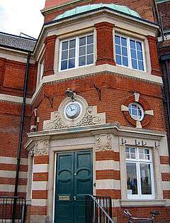
Dulwich Library, which opened on 24 November 1897 is nearby.
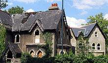
549 Lordship Lane: the "Concrete House"
One of the most architecturally interesting buildings in the area is at 549 Lordship Lane. The so-called "Concrete House" is a former derelict grade II listed building, now restored and back in use, and is an example of 19th-century concrete house. It is believed that it is the only surviving example in England.[9]
The Concrete House was built in 1873 by Charles Drake of the Patent Concrete Building Company. In 1867 the builder had patented the use of iron panels for shuttering rather than timber.
It was on the Heritage at Risk Register from 1994 to 2013 when it was removed following its successful repair and conversion. Having fallen vacant in the 1980s and developing serious structural problems, it has been fully restored and converted to five flats in shared ownership. It then won an award from English Heritage, the Angel Commendation.[10]
Sport and leisure
East Dulwich is home to two non-league football clubs, Dulwich Hamlet and Fisher F.C., who share a ground at Champion Hill.
See also
References
- Notes
- ↑ "Southwark Ward population 2011". Neighbourhood Statistics. Office for National Statistics. Retrieved 12 October 2016.
- ↑ The Dulwich Society: .
- ↑ "Camberwell", British History online
- ↑ Hibbert, Christopher; Booth, Pat; Weinreb, Ben (1983). The London encyclopedia. New York: Macmillan. ISBN 0-333-32556-7.
- ↑ "Dulwich Fire Station c.1900. Built 1892.". London Fire Brigade. 1900. Retrieved 2009-05-02.
- ↑ "Welcome to Southwark libraries". Southwark Council. Retrieved 2009-05-03.
- ↑ "Good buy, Mr Chips". The Times. 11 June 2004.
- ↑ http://www.geograph.org.uk/photo/2018876
- ↑ "549 Lordship Lane, East Dulwich, Southwark, c.1930". Ideal Homes. Archived from the original on 14 September 2009. Retrieved 2009-05-03.
- ↑ Wilding, Mark (7 October 2013). "The Concrete House restoration wins English Heritage commendation". bdonline.co.uk. Retrieved 22 April 2014.
- Bibliography
- Boast, Mary (1990). The Story of Dulwich. London Borough of Southwark Local Studies Library. pp. 36 pages. ISBN 0-905849-09-4.
- Beasley, John D (1998). East Dulwich: an illustrated alphabetical guide. South Riding Press. pp. 152 pages. ISBN 1-874401-08-X.
- Green, Brian (1988). Victorian and Edwardian Dulwich. Quotes Ltd. pp. 140 pages. ISBN 0-86023-432-0.
- William Harnett Blanch (1877). Ye parish of Cam̃erwell: A brief account of the parish of Camberwell, its history and antiquities. E.W. Allen., page 220.
External links
| Wikimedia Commons has media related to East Dulwich. |
| Districts | 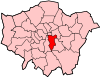 | |
|---|---|---|
| Attractions |
| |
| Markets | ||
| Bridges and tunnels | ||
| Parks and open spaces |
| |
| Constituencies | ||
| Tube and rail stations | ||
| Other topics | ||