South London
| South London | |
|---|---|
| Boroughs of South London | |
 | |
| Coordinates: 51°27′N 0°06′W / 51.45°N 0.1°WCoordinates: 51°27′N 0°06′W / 51.45°N 0.1°W | |
| Sovereign state | United Kingdom |
| Country | England |
| Region | London |
| Comprises | Bexley, Bromley, Croydon, Greenwich, Kingston, Lambeth, Lewisham, Merton, Richmond, Southwark, Sutton and Wandsworth |
| Area | |
| • Total | 249.34 sq mi (645.78 km2) |
| Population | |
| • Total | 2,835,200 |
| • Density | 11,000/sq mi (4,400/km2) |
South London is the southern part of London, England.
According to the 2011 official Boundary Commission for England definition,[1] the area includes the London boroughs of Bexley, Bromley, Croydon, Greenwich, Kingston, Lambeth, Lewisham, Merton, Richmond, Southwark, Sutton and Wandsworth.
Boundary Commission
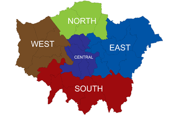
The River Thames divides Greater London into two parts. The southern part includes the historic central areas of Southwark, Lambeth and Bankside and also maritime Greenwich. The area has only a small section of the London Underground network, but has a much more extensive suburban railway system than North London[2] and is the location of all of London's tram services.
This area is made up of the London boroughs of Bexley, Bromley, Croydon, Greenwich, Kingston, Lambeth, Lewisham, Merton, Richmond, Southwark, Sutton and Wandsworth. This definition is used by the Boundary Commission for England.[3] The London Borough of Richmond upon Thames includes sections on both sides of the River Thames and the boundary commission class the entire district as part of South London,[3] pairing it with Kingston upon Thames for the purposes of devising constituencies.[4]
In 1965 Greenwich, Lambeth, Lewisham, Southwark and Wandsworth were designated Inner London boroughs and Bexley, Bromley, Croydon, Kingston, Merton, Richmond and Sutton were designated Outer London boroughs.[5]
Planning sub-region
.svg.png)
For the purposes of the London Plan, there was a South London sub-region in operation from 2004 to 2008 consisting of Bromley, Croydon, Kingston, Merton, Richmond and Sutton.[6] In 2001 this area had a population of 1,329,000.[7] This definition is used by organisations such as Connexions.[8]
Between 2008 and 2011 it was replaced with a South East sub-region consisting of Southwark, Lewisham, Greenwich, Bexley and Bromley and a South West sub-region consisting of Croydon, Kingston, Lambeth, Merton, Sutton, Richmond and Wandsworth.[9]
In 2011 a new South London region was created consisting of Bromley, Croydon, Kingston, Merton, Sutton and Wandsworth. Bexley, Greenwich and Lewisham. Richmond now lies within the West London region, and Lambeth and Southwark are part of the Central London region.
List of boroughs
This list includes all boroughs included in the Boundary Commission area:
| London borough | Postcode areas | 2008 sub-region | London Assembly[10] | |
|---|---|---|---|---|
| |
Bexley | DA, SE | South East | Bexley and Bromley |
| |
Bromley | BR, DA, SE, TN | South East | Bexley and Bromley |
| |
Croydon | CR, SE, SW | South West | Croydon and Sutton |
| |
Greenwich | SE, DA, BR | South East | Greenwich and Lewisham |
| |
Kingston | KT, SW, TW | South West | South West |
| |
Lambeth | SE, SW | South West | Lambeth and Southwark |
| |
Lewisham | SE, BR | South East | Greenwich and Lewisham |
| |
Merton | CR, KT, SM, SW | South West | Merton and Wandsworth |
| |
Richmond | SW, TW | South West | South West |
| |
Southwark | SE | South East | Lambeth and Southwark |
| |
Sutton | CR, KT, SM | South West | Croydon and Sutton |
| |
Wandsworth | SW | South West | Merton and Wandsworth |
Climate
South London is, like other parts of London and the UK in general, a temperate maritime climate according to the Köppen climate classification system. Three Met Office weather stations currently collect climate data south of the river; Kew, Hampton and Kenley Airfield, on the southern edge of the urban area.[11] Long term climate observations dating back to 1763[12] are available for Greenwich, although observations ceased here in 2003.
Temperatures increase towards the Thames, firstly because of the urban warming effect of the surrounding area, but secondly due to altitude decreasing towards the river, meaning the southern margins of South London are often a couple of degrees cooler than those areas adjacent to the Thames. Often snow can be seen to lie on the North Downs near Croydon when central London is snow free.
The record high temperature at Greenwich is 37.5 °C (99.5 °F) recorded during August 2003.[13] Sunshine is notably lower than other London area weather stations (by about 50–100 hours a year), suggesting Greenwich may be a fog trap in winter, and that the hillier land to the south may obscure early morning and late evening sunshine.
The highest temperature recorded across South London was 38.1 °C (100.6 °F) on the same occasion at Kew Gardens. Although the Met Office accepts a higher reading from Brogdale in Kent, many have questioned the accuracy of this[14] and regard the Kew reading as the most reliable highest UK temperature reading.
| Climate data for Greenwich 7m asl 1971-2000, | |||||||||||||
|---|---|---|---|---|---|---|---|---|---|---|---|---|---|
| Month | Jan | Feb | Mar | Apr | May | Jun | Jul | Aug | Sep | Oct | Nov | Dec | Year |
| Average high °C (°F) | 7.9 (46.2) |
8.2 (46.8) |
10.9 (51.6) |
13.3 (55.9) |
17.2 (63) |
20.2 (68.4) |
22.8 (73) |
22.6 (72.7) |
19.3 (66.7) |
15.2 (59.4) |
10.9 (51.6) |
8.8 (47.8) |
14.8 (58.6) |
| Average low °C (°F) | 2.4 (36.3) |
2.2 (36) |
3.8 (38.8) |
5.2 (41.4) |
8.0 (46.4) |
11.1 (52) |
13.6 (56.5) |
13.3 (55.9) |
10.9 (51.6) |
8.0 (46.4) |
4.8 (40.6) |
3.3 (37.9) |
7.2 (45) |
| Average precipitation mm (inches) | 51.9 (2.043) |
34.0 (1.339) |
42.0 (1.654) |
45.2 (1.78) |
47.2 (1.858) |
53.0 (2.087) |
38.3 (1.508) |
47.3 (1.862) |
56.9 (2.24) |
61.5 (2.421) |
52.3 (2.059) |
54.0 (2.126) |
583.6 (22.976) |
| Mean monthly sunshine hours | 45.9 | 66.1 | 103.2 | 147.0 | 185.4 | 180.6 | 190.3 | 194.4 | 139.2 | 109.7 | 60.6 | 37.8 | 1,461 |
| Source: MetOffice[15] | |||||||||||||
Associated organisations
See also
References
- ↑ Boundary Commission for England, London - London 2011 amendment
- ↑ Wolmar, Christian (2004). The Subterranean Railway: How the London Underground Was Built and How It Changed the City Forever. Atlantic Books. ISBN 1-84354-023-1.
- 1 2 Boundary Commission for England - South London Boroughs
- ↑ Boundary Commission for England Fifth Periodical Report Cm 7032
- ↑ Office of Public Sector Information - London Government Act 1963 (c.33) (as amended)
- ↑ Greater London Authority, The London Plan: Sub-Regional Development Framework - South London
- ↑ Greater London Authority, The London Plan: The Sub Regions
- ↑ Connexions - South London
- ↑ Greater London Authority - Draft Further Alterations to the London Plan
- ↑ London Assembly - London Assembly Constituency Information. Retrieved on 22 February 2008.
- ↑ "Station Locations". MetOffice.
- ↑ "Greenwich Long term data". MetOffice.
- ↑ "Greenwich 2003 Maximum". MetOffice.
- ↑ "August 2003". Weather Journal.
- ↑ "Greenwich 1971-2000". Met Office. Retrieved 23 Sep 2011.
External links
| Wikivoyage has a travel guide for South London. |
- Time Out editors (1 May 2009). "North London v South London - The debate". Time Out London.
- Alan Rutter and Peter Watts (13 December 2005). "North London v South London - The debate". Time Out London.