East Sahuarita, Arizona
| East Sahuarita, Arizona | |
|---|---|
| CDP | |
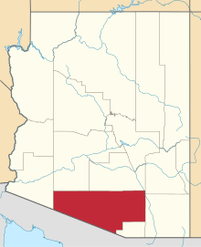
 Location in Pima County and the state of Arizona | |
| Coordinates: 31°56′43″N 110°55′6″W / 31.94528°N 110.91833°W | |
| Country | United States |
| State | Arizona |
| County | Pima |
| Area | |
| • Total | 14.6 sq mi (37.9 km2) |
| • Land | 14.6 sq mi (37.9 km2) |
| • Water | 0.0 sq mi (0.0 km2) |
| Elevation | 2,782 ft (848 m) |
| Population (2000) | |
| • Total | 1,419 |
| • Density | 97.2/sq mi (37.4/km2) |
| Time zone | MST (no DST) (UTC-7) |
| FIPS code | 04-21537 |
| GNIS feature ID | 1853157 |
East Sahuarita is a census-designated place (CDP) in Pima County, Arizona, United States. The population was 1,419 at the 2000 census.
Geography
East Sahuarita is located at 31°56′43″N 110°55′6″W / 31.94528°N 110.91833°W (31.945388, -110.918388).[1]
According to the United States Census Bureau, the CDP has a total area of 14.6 square miles (37.9 km²), all of it land.
Demographics
As of the census[2] of 2000, there were 1,419 people, 472 households, and 376 families residing in the CDP. The population density was 96.9 people per square mile (37.4/km²). There were 512 housing units at an average density of 35.0/sq mi (13.5/km²). The racial makeup of the CDP was 77.59% White, 0.56% Black or African American, 2.18% Native American, 0.56% Asian, 16.35% from other races, and 2.75% from two or more races. 48.06% of the population were Hispanic or Latino of any race.
There were 472 households out of which 42.8% had children under the age of 18 living with them, 60.8% were married couples living together, 12.5% had a female householder with no husband present, and 20.3% were non-families. 15.0% of all households were made up of individuals and 4.7% had someone living alone who was 65 years of age or older. The average household size was 3.01 and the average family size was 3.35.
In the CDP the population was spread out with 32.1% under the age of 18, 9.2% from 18 to 24, 29.2% from 25 to 44, 22.2% from 45 to 64, and 7.2% who were 65 years of age or older. The median age was 32 years. For every 100 females there were 97.9 males. For every 100 females age 18 and over, there were 98.1 males.
The median income for a household in the CDP was $33,083, and the median income for a family was $37,292. Males had a median income of $29,107 versus $21,406 for females. The per capita income for the CDP was $12,484. About 15.7% of families and 24.0% of the population were below the poverty line, including 30.6% of those under age 18 and 14.3% of those age 65 or over.
History
East Sahuarita is part of the broader town of Sahuarita.
Sahuarita was founded in 1911[3] and incorporated in 1994.[4]
Hohokam (200 to 1450)
The first known human inhabitants of the Sahuarita region were the Hohokam people, which may be the ancestors of the modern day Tohono O'odham Nation. The Hohokam were known for their highly innovative and extensive use of irrigation. The Hohokam were a very peaceful people, they had extensive trade routes extending to mesoamerica, and showed many cultural influences from their southern neighbors.[5]
Sobaipuri (1400 - 1900)
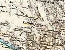
The Sobaipuri were possibly related to the Hohokam, and occupied the Southern portion of the Santa Cruz, with the Pima to their North and South. While Coronado passed just East of Sahuarita in 1521, it wasn't until Eusebio Kino's 1691 journey along the Santa Cruz River that he met the leaders of the Sobaipuri people. Kino was a true champion of the indigenous Indians, opposing forced labor in mines by Spanish overseers. Kino would later go on to found the Mission San Xavier del Bac in 1699, just north of Sahuarita. In 1775, Francisco Garcés would follow the same path, laying the groundwork for the founding of Tucson.[5]
Spanish & Mexican control (1775 - 1853)
In 1775, after building a series of missions in the region, the Spanish established a fort in the Tucson region to control the Native American settlements nearby. This just north of Sahuarita, which effectively placed the region under Spanish control. Eventually a town came to be and was named Tucson. After the Mexican War of Independence in 1821, the region came under Mexican control until they sold the land to the United States as part of the Gadsden Purchase.
Incorporation into the U.S. (1854 -1874 )
In 1854, following the Gadsden Purchase, Sahuarita would become a part of the Territory of New Mexico, in the United States of America. In the same year, Andrew B. Gray would travel the region on behalf of the Texas Western Railroad, in order to run a preliminary survey of the region. Meanwhile, the Native American peoples of the region were being pushed onto each other's land through American expansionism. In 1857, the Sobaipuri, who had acted as a buffer between the hostile Mexicans to the south and Apache to the north, finally collapsed under the pressure and vacated the area, generally moving westward to Papago territory. Sahuarita was a part of the Confederate Arizona Territory between 1861 and 1862 before being captured by the Union and incorporated into Arizona Territory in 1863. In 1867, Fort Crittenden was created between Sonoita and Patagonia in order to support the establishment of American settlements in the Santa Cruz Valley. In 1874, the San Xavier reservation was created, presently called the Tohono O'odham Reservation, and Native Americans were forcibly relocated to the reservation.[5]
Sahuarita on the map (1870 - 1925)
An 1870 map of Arizona shows an "Indian Village" just north of Sahuarita.[6] The earliest known reference to the town can be found on a German map from 1875, which labels the town "Sahuarito".[7] The first known US map to list the town came in 1879, by the US Department of Interior, calling the town "Saurita".[8] The Saurita town name would continue to be found on successive maps of 1880[9] and 1890.[10] Finally, a 1925 map of "Auto Trails" (e.g. roadways) of Arizona and New Mexico lists "Continental" instead of Sahuarita. The roadway at the time was an "improved road", one step inferior to a "paved road", laying the route to what today is called the Old Nogales Highway.[11]
Sahuarita Ranch (1879 - 1886)
In 1879 Sahuarita Ranch was created by James Kilroy Brown. Brown choose the name Sahuarita due to the preponderance of saguaros in the area. The ranch was used as a staging area between Tucson, Arivaca, and Quijotoa. A small community developed in the area named Sahuarito, while the railroad laid tracks through the area (which remain to this day) and established a station and post office. Although originally surveyed by the Texas Western Railroad, the route would soon be run by the Southern Pacific Railroad up until the late 20th century. Brown sold his ranch in 1886 which caused the region to stagnate for three decades.[12]
During this time, the hub of Sahuarita commerce was at the intersection of Sahuarita Road and Nogales Highway, in the form of the One Stop Market and Sahuarita Bar and Grill.[13] These 130-year-old buildings remain intact, but they are scheduled to be demolished for a road expansion: "While some have said the 1 Stop and the shuttered Sahuarita Bar on the north side of Sahuarita Road were long-time fixtures that might deserve historic recognition, the longest-serving council member, Charles Oldham, and the council member who lives closest, Marty Moreno, both said the convenience store should make way for badly needed road improvements. Oldham said, “It’s in the way”."[14]
Continental Farm (1915 - present)
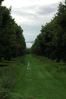
The Continental Farm of Sahuarita plays a central role in town history. In 1915, worried about the possibility of a German blockade of rubber imports, Bernard Baruch, Joseph Kennedy and J.P. Morgan founded the farm along the Santa Cruz River with hopes of growing guayule: plants that provide rubber. The project was abandoned after the end of World War I, and in 1922, was sold to Queen Wilhelmina of the Netherlands. The Queen rented the land to cotton farmers, in what would be the primary crop for the following four decades. In 1948, R. Keith Walden relocated the Farmers Investment Co. (FICO) from California to Arizona, buying the Continental Farm lands from the Queen. In 1965, over fears of a fall in demand for cotton resulting from the advent of synthetic fibers, Walden switched his crop to pecans. Today, the FICO pecan orchard is the largest in the world, with over 6,000 acres (24 km2) and 106,000 trees.[15]
World War II (1942 - 1945)
During World War II, Sahuarita was home to the Sahuarita Airstrip which was used to train bomber pilots for service in the war. Camp Continental, a labor camp for German prisoners of war was also located in Sahuarita. The location of the camp was around what is now Continental Ranch, West of the Nogales Highway and the Quail Crossing Boulevard intersection. It was established around November, 1944, as one of 21 "branch" POW camps established throughout the state. The population of 250 prisoners primarily worked in agriculture, tending to cotton and vegetable crops. More than one escape attempt was made by the Germans, all of which failed.[16]
Sahuarita Bombing & Gunnery Range (1942 - 1978)

The Army Air Corp from Davis-Monthan Air Force Base first used this 27,046-acre (109.45 km2) range in April, 1942 for practice bombing runs. The Sahuarita Flight Strip was completed in 1943, with a 5,540-foot (1,690 m) paved runway, and the bombing runs ceased shortly thereafter. The site included 12 buildings in addition to the airstrip, and four observational towers. In 1950, bomber crews operating out of Carswell AFB, TX, restarted bombing runs on the range, which would last until 1962, with the airway strip remaining in use as an emergency landing strip thereafter. The Federal government soon released the land to the State of Arizona in 1978, who in turn leased the land to a cattle rancher. Presently, the former airstrip has been converted into a roadway that leads to "Sahuarita Park", while the remaining land remains in use for cattle grazing. The U.S. Army Corps of Engineers is continuing its longstanding efforts of identifying remaining munitions, preventing environmental contamination, and protecting several endangered species in the area, including jaguars, spotted owls, among others. Several different types of expended ammunition rounds can be found throughout the range, most of which found are 10 to 57 mm rounds. Shrapnel from the dropped ordnance also litters the range, as well as dozens of crushed olive drab ammunition boxes. Shell casings and magazine clips can also be found, along with JATO tanks and large crosses, constructed of wood with orange reflectors for visibility from the air. The crosses were used as targets for the airmen in training. Many United States Tobacco Company tins have been found, discarded by the several different aviators who occupied the area during its military days. The actual airstrip is now used as a road leading to Sahuarita Park and the Edge Charter School. Both of which were built among the remains of the older air force buildings.[17][18]
Cold War
Sahuarita contains the Titan Missile Museum, built in 1963 during the height of the Cold War, which is the only Titan Missile site in the world accessible to the public. The actual Titan II missile, the most powerful nuclear missile on standby in the US, remains in the silo for visitors to see. The Sahuarita Airstrip continued to be used by the U.S. Airforce throughout most of the Cold War.[19]
Water sustainability
In the desert southwest, water sustainability is a major concern. According to a 2007 report by Pima County, 76,000 acre feet (94,000,000 m3) of water was pumped from the aquifer in the Upper Santa Cruz Valley in 2006 [in the report referred to as the Green Valley area, which includes Sahuarita], with 85 percent of that water being used for mining and agriculture. The remaining 15 percent was split between water used for golf courses and residential/commercial water use. The report explains that "The Green Valley area does not have a sustainable water supply given current groundwater pumping rates... the water table in Green Valley has been declining in past years, and is expected to decline even faster as water demands [continue to increase]...". The report concludes that "Water supplies will become critical within the next ten years."[20]
The Upper Santa Cruz Valley has several "major water users", all pumping water out of the same aquifer. None of these are owned by Pima County, the town of Sahuarita, nor Green Valley. The major water users are all private companies: ASARCO-Mission Mine, Phelps Dodge Sierrita Mine; Farmers Water Company; Sahuarita Water Company, Las Quintas Serenas Water Company, Quail Creek Water Company, Community Water Company of Green Valley, and the Green Valley Water District. The proliferation of water companies can be partially explained by the fact that the actual water in the aquifer is not owned by anyone, thus any amount of water can be pumped out, with costs limited only to drilling, pumping, distribution, etc.[21]
See also
References
- ↑ "US Gazetteer files: 2010, 2000, and 1990". United States Census Bureau. 2011-02-12. Retrieved 2011-04-23.
- ↑ "American FactFinder". United States Census Bureau. Archived from the original on 2013-09-11. Retrieved 2008-01-31.
- ↑ "Community Profile for Sahuarita" (PDF). Community Profile for Sahuarita. Arizona Department of Commerce. October 22, 2007. Retrieved October 22, 2007.
- ↑ "Sahuarita at a Glance" (PDF). Town Facts & Figures. Town of Sahuarita. October 22, 2007. Retrieved October 22, 2007.
- 1 2 3 Henry, P.; Bufkin, D: "Historical Atlas of Arizona". University of Oklahoma Press © 1979
- ↑ "Arizona, New Mexico". by Mitchell, Samuel Augustus. David Rumsey Map Collection. 1870. Retrieved October 23, 2007.
- ↑ "Die Vereinigten Staaten Von Nord-Amerika In 6 Blattern". The United States in 6 sheets, by Stieler, Adolf. David Rumsey Map Collection. 1875. Retrieved October 23, 2007.
- ↑ "Territory of Arizona". U.S. General Land Office. David Rumsey Map Collection. 1879. Retrieved October 23, 2007.
- ↑ "Official Map Of The Territory Of Arizona.". Eckhoff, E.A. ; Riecker, P. David Rumsey Map Collection. 1880. Retrieved October 23, 2007.
- ↑ "Arizona, New Mexico.". Mitchell, Samuel Augustus. David Rumsey Map Collection. 1890. Retrieved October 23, 2007.
- ↑ "Rand McNally Official 1925 Auto Trails Map Arizona New Mexico.". David Rumsey Map Collection. 1925. Retrieved October 23, 2007.
- ↑ "History and Information about Sahuarita". Arizona's names: X marks the place. Falconer Pub. Co. October 22, 2007. Retrieved October 22, 2007.
- ↑ Goorian, Philip (2002). Green Valley, Arizona. Arcadia Publishing. pp. 51–70. ISBN 0-7385-2072-1.
- ↑ "Sahuarita Sun". October 25, 2007. Retrieved January 8, 2008.
- ↑ "The Pecan Store". Company History. FICO. October 22, 2007. Retrieved October 22, 2007.
- ↑ "Sahuarita once had POW camp". Many residents surprised to learn German Prisoners of War were housed in area as no traces of facility remain. Arizona Daily Star. May 25, 2006. Archived from the original on August 21, 2007. Retrieved October 22, 2007.
- ↑ "Abandoned & Little-Known Airfields". Sahuarita AF Flight Strip, Sahuarita, AZ. Paul Freeman. 2004. Retrieved October 22, 2007.
- ↑ "Sahuarita Air Force Range" (PDF). Site Inspection Report. U.S. Army Corps of Engineers. August 2006. Retrieved October 22, 2007.
- ↑ Fountain, Henry (January 7, 2007). "Strange Love". New York Times. Retrieved October 24, 2007.
- ↑ "Long Term Green Valley Water Supply" (PDF). Long Term Green Valley Water Supply. Pima County. October 2, 2007. Retrieved November 30, 2007.
- ↑ "Groundwater Awareness League". Representing the voice of the people... about their water supply. GAL. 2007. Retrieved November 30, 2007.
External links
Coordinates: 31°56′43″N 110°55′06″W / 31.945388°N 110.918388°W