El Negrillar
| El Negrillar | |
|---|---|
| Negros de Aras | |
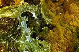 The cones in the image centre and associated black lava flows form the El Negrillar volcanic field. | |
| Highest point | |
| Elevation | 3,500 m (11,500 ft) [1] |
| Coordinates | 24°11′S 68°15′W / 24.18°S 68.25°W [1] |
El Negrillar is a volcanic field in the Andes. Located west of the Cordón de Púlar, it generated cinder cones and andesitic lava flows. The volcanic field may be of Holocene age. Parts of the Socompa debris avalanche overlie the field.[1] The cones have volumes of less than 0.1 cubic kilometres (0.024 cu mi) and lava flows are thin and branch out dendritically.[2] Lava flows are up to 100 metres (330 ft) thick and overlie the Salín Formation.[3] The origin of the more basic lavas of this field has been explained with olivine differentiation.[4]
See also
References
- 1 2 3 "El Negrillar". Global Volcanism Program. Smithsonian Institution. Retrieved 3 September 2015.
- ↑ Deruelle, Bernard (1982). "Petrology of the plio-quaternary volcanism of the South-Central and Meridional Andes". Journal of Volcanology and Geothermal Research. 14 (1-2): 77–124. doi:10.1016/0377-0273(82)90044-0. ISSN 0377-0273.
- ↑ Rissmann, Clinton; Leybourne, Matthew; Benn, Chris; Christenson, Bruce (2015). "The origin of solutes within the groundwaters of a high Andean aquifer". Chemical Geology. 396: 164–181. doi:10.1016/j.chemgeo.2014.11.029. ISSN 0009-2541.
- ↑ Actas, II Congreso Geologico Chileno: ciudad de arica del 6 al 11 de Agosto de 1979 (in French). Instituto de Investigaciones Geologicas. 1980. p. 218.
This article is issued from Wikipedia - version of the 11/2/2016. The text is available under the Creative Commons Attribution/Share Alike but additional terms may apply for the media files.